

CANADA- NOVA SCOTIA- Nouvelle-Écosse- history of Acadians -Nova Scotia
----------------------------
Inuit Community and Culture- IDLE NO MORE - listen 2 the beauty and silence of Canada's Inuit Peoples- their culture defines and honours our Canada.... our Rangers of the North- our Warriors make us proud of our Canadian Military.
BLOGGED:
CANADA MILITARY NEWS: Nov26-SEALS- IDLE NO MORE CANADA- FREE TRADE THIS CANADA: Every four or five days Europe kills more animals for their fur than the entire annual Canadian hunt does in a year
AND...
blogged
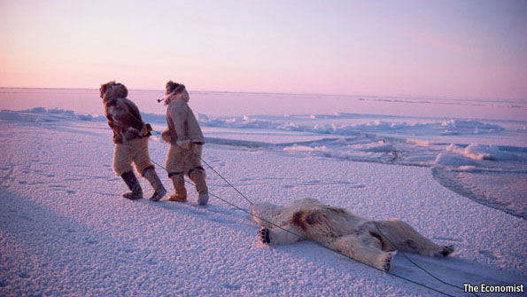
IDLE NO MORE CANADA- MI'KMAQ MONTH IN NOVA SCOTIA- 11,000 years- We mourn Albino Moose murdered- must learn Mi'kmaq nature's way pls./Some fall fun Annapolis Valley/Good Books/Mi'kmaq traditions, history and videos
-------------------


Cathy Sawer volunteers at the Qayuqtuvik Soup Kitchen in Iqaluit, Nunavut. Protests have popped up across the territory over food insecurity


Look at
the historical significance of CANADA’S INNU- INUIT PEOPLES- SO WHY R WE
STARVING THEM AND NOT ENSURING THEIR WELL BEING... why have Canadians given
$$$$$Millions and $$$$millions 2 the Africas India Asias whilst our own
beautiful First Peoples of Canada were starving and in total hardships......
SHANIA TWAIN- feed your own children first-
that is Canada’s travesty on this day imho- IDLE NO MORE CANADIANS-
Innu/Inuit peoples matter- they’re us
When we think
of all those years and years back in the 70s millions of us young and older
Canadians sending our wages $$$$$ 2 feed so many in horrible hard lands.... and
2da we look at the shame that we have NOT fed our own Canadian First Peoples
Innu and the hardships of First Nations peoples.... and just want 2 weep... HOW
DARE UNITED NATIONS AND ALL POLITICIANS BITCH ABOUT THE HARD PLIGHT OF OUR
FIRST PEOPLES ... WHEN THEY DID NOTHING...
Let’s fix
this Canada.... let’s fix this..
SHANIA
TWAIN SAID IT BEST... feed your own first...
Canada's Shania
Twain wrote Black Eyes, Blue Tears back in the 90s.... and put it 2 music and
played it around the world.... Shania kicked country music's ass and the black
hats... and woke the world up 2 girls count... girls are equal and ... girls
can do anything they dream on.... Shania Twain was adopted when she was 2 by
Objiway Gerry Twain (she adored her Grandpa Twain) who adored his wife, Sharon.
Shania grew up in the 'Reserves, Bands' of First Peoples of Canada - 10,000 and
knew exactly what it was like 2 live in poverty, dispair and the injustice of
the horrible treatment of Canada's First Peoples as all Governments of Canada
and all polticial stripes- throwaway trash AND HISTORICALLY OF THE ABUSE ON ABUSE BY FIRST NATIONS MEN ON THEIR WOMEN AND CHILDREN..... Shania Twain is a hero to so
many women globally.... and has over one billion fans.... shania walked the
talk and kept her soul, her honour and the respect of herself and her fans.... AND SHANIA TWAIN KNEW REAL PURE AND DANGEROUS
HUNGER ALONG WITH HER FAMILY AND PEOPLE.....
Shania started food banks at all her shows, including kids from each and every town, supported and played 4 troops be4 it became noticed, and said - feed your own kids first and those of your communities, villages and cities- 4God's sake look after ur kids..... Shania is one of China's favourite artists- and one of the world's - Shania made women matter and girls believe in empowerment of education and freedom... and equality....
BLACK EYS, BLUE TEARS... SHANIA TWAIN
http://www.youtube.com/watch?v=26Fd5Q2-VC0
"Black Eyes, Blue Tears"
Black eyes, I don't need 'em
Blue tears, gimme freedom
Positively never goin' back
I won't live where things are so out of whack
No more rollin' with the punches
No more usin' or abusin'
I'd rather die standing
Than live on my knees
Begging please-no more
Black eyes-I don't need 'em
Blue tears-gimme freedom
Black eyes-all behind me
Blue tears'll never find me now
Definitley found my self esteem
Finally-I'm forever free to dream
No more cryin' in the corner
No excuses-no more bruises
I'd rather die standing
Than live on my knees
Begging please-no more
Black eyes-I don't need 'em
Blue tears-gimme freedom
Black eyes-all behind me
Blue tears'll never find me now
I'd rather die standing
Than live on my knees, begging please...
Black eyes-I don't need 'em
Blue tears-gimme freedom
Black eyes-all behind me
Blue tears'll never find me now
It's all behind me, they'll never find me now
Find your self-esteem and be forever free to dream
----------------
news.nationalpost.com/.../canadian-inuit-going-hungry-study Cached
By Peggy Curran. MONTREAL — Six
out of 10 Inuit in Canada’s Far North don’t get enough to eat or
are eating the wrong things, says a comprehensive study by a ...
2007-2008 Inuit Health
Survey; 2007-2008 Inuit Child Health Survey; Visit the Council of
Canadian Academies; World Health Organization on food security
----------------
1.
PDF]
This discussion paper provides an initial overview
of the some of the issues concerning ... project done in Kugaaruk, Nunavut,
by the Food Mail Program. 1 ..... ($205,194 in 2000 and $500,000 in
20032004) to communities to provide food,.
1.
[PDF]
ing the month of March 2000 – almost double
the 1989 figure;. • despite reports of .... hunger problem quite serious or very
se- rious. .... in Nunavut and the Yu-.
30 Sep 2005 ... If you asked 10 people in Nunavut
whether they or someone in their ... The new hunger statistics appear in an
article in the May, 2005 ... It was calculated using data from the 2000-2001 Canadian Community
Health Survey.
21 Oct 2013 ... Encyclopedia of ...
In the 1500s, Martin Frobisher thought they were Asians and took a ... that had enabled Inuit (“the people”)
to thrive for centuries in a harsh ... Some Inuit in Canada's high Arctic,
as well as further south, ...
------------------
shania twain.... all those years... why didn't w efeed our own BLOG
-----
news.nationalpost.com/.../canadian-inuit-going-hungry-study Cached
By Peggy Curran. MONTREAL — Six
out of 10 Inuit in Canada’s Far North don’t get enough to eat or
are eating the wrong things, says a comprehensive study by a ...
2007-2008 Inuit Health
Survey; 2007-2008 Inuit Child Health Survey; Visit the Council of
Canadian Academies; World Health Organization on food security
----------------
NEWS COVERAGE ON EXTREME TERRORIST AND TERRORISM ONLY
---
Food-cost crisis shames Far North: ‘We can’t pretend
it doesn’t exist’
STEVE RENNIE THE
CANADIAN PRESS
Last Updated January 24, 2015 - 9:23am
Last Updated January 24, 2015 - 9:23am
---------------
1. [PDF]
Ecosystem Initiative of
Environment Canada for recognising the value of Inuit ... Canada for financing the publication of this book. ..... the food
security of Inuit and Inuit com- munities, as both ...... items in new places,
including the community garbage dump. ...... the long journey to the community; and dig
ice houses into the ...
16 Jan 2015 ...
She said many of donors (from across Canada) are living paycheque to
.... I just want to say that it is an Inuit tradition to share food.
.... (they have the highest rate of suicide, they are digging in the garbage for food) this
is ...
21 Jan 2014 ...
Michael Byers Why Canada's search for an icebreaker is an Arctic
... Across the territory, just one in four Inuit students finishes high school.
... Hunters bring food when they go out and do not leave their garbage on the ...
Blizzards also bring a lot of snow and huge snow drifts to play on, or dig in, for
hours.
4. [PDF]
Dr. Scott Redhead, Agriculture
Canada; and Jane Tagak. Cover illustration “Man and .... It is important to make clear that in Inuit societies
medical knowledge never existed ..... When we were studying the uses for seal, we
learned that eating seal can help the ...... We did not waste the skins
as they were a source of income.
5. [PDF]
31 Mar 2014 ... A
Report for the Canadian Women's Foundation. January, 2014 ... The
first Inuit Impact Benefit Agreement (IIBA) for Meadowbank was signed in
...... The employment of women, primarily in food preparation and
housekeeping ..... “Digging Women: Towards a New Agenda for Feminist Critiques
of Mining.
--------------
Hunger may be stunting Inuit children’s growth
BOB WEBER THE CANADIAN
PRESS
Published August 27, 2014 - 5:06pm
Published August 27, 2014 - 5:06pm
Hunger
among Inuit families is so prevalent in Arctic Quebec that it could be why
almost half their children are shorter than average, new research suggests.
A
paper published in the Journal of the Canadian Public Health Association says
the height discrepancy implies that food insecurity is a long-running problem —
not just something that happens occasionally.
“The
observed association between food insecurity and linear growth suggests that
the diet quality and quantity of children from food-insecure households had
been compromised for a long time,” the paper says.
There
have been numerous studies in recent years documenting food insecurity in the
North, which is defined as occurring when a family feels there isn’t enough on
the table and either children or adults have to eat less as a result.
A
McGill University study found in 2010 that 41 per cent of Nunavut children
between three and five lived in homes where they either had no food for an
entire day or where their parents couldn’t afford to feed them at least part of
the time. Two-thirds of the parents said there were times when they ran out of
food and couldn’t afford to buy more.
In a
2012 study, Statistics Canada found that 22 per cent of Inuit reported going
hungry during the previous year because they couldn’t afford food.
Nunavut’s
territorial nutritionist has found nearly three-quarters of Inuit preschoolers
live in food-insecure homes. Half of youths 11 to 15 years old sometimes go to
bed hungry.
Wednesday’s
study by researchers affiliated with Laval University is believed to be the
first to look into the physical consequences. They looked at 294 children
between the ages of eight and 14 from several villages in Nunavik, the name for
northern Quebec. About half of those children came from homes considered
food-insecure.
They
found a high correlation between slow growth rates and food insecurity.
“Food-insecure
children were significantly shorter in stature, by an average of two
centimetres, than their food-secure counterparts,” the report says. “For
children of this age group, this is close to half a year’s growth.”
They
also found children from hungry families tended to be more anemic.
“The
results of this study raise concerns about the long-term implications of food
insecurity for Nunavik,” the report concludes.
Many
causes have been advanced to explain hunger in the North.
Jobs
are scarce, leading to poverty, which combined with high prices in grocery
stores restricts the amount of food families can afford. So-called “country
food” — traditional foods such as caribou, char or seal — is also made
expensive by the need to buy hunting supplies and ammunition.
The
federal government subsidizes the cost of shipping food deemed healthy and
nutritious, but northerners remain skeptical about whether the program actually
reduces grocery bills.
Prime
Minister Stephen Harper faced protests over high food costs at his Iqaluit stop
earlier this week during his summer northern tour.
------------------
1.
[PDF]
Suwarak; 1999) in Nunavut Territory, the issue
of providing sign language ..... estimate of the general population in Nunavut
is 27,039 (Nunavut Bureau of Statistics, 2000).
Thus the .... hunter and employee of the local power corporation.
14 Dec 2014 ... IQALUIT, Nunavut -
High food prices and pervasive poverty in Nunavut mean ... people of which 80 per cent are Inuit, and more
than a third are under 15 years old. ... $2.9k raised
so far raised of $50k goal 100 Days left.
2.
[PDF]
In short, there is a serious problem in Nunavut
that threatens individual and community health. While the ... 50. 40. 30.
20. 10. 0. Nunavut. Canada Alberta. British Columbia. Manitoba. New Brunswick ....
Ungalaq, an otherwise shy 25-year-old.
www.cbc.ca/.../nunavut-s-food-problems-prompt-intense-scrutiny-hopes-for-change-1.2872977
14 Dec 2014 ... Dozens of people wait
patiently in -40 C cold, braced against the gusting shards of wind. ... The 65-year-old and her fellow
volunteers have been in the kitchen ... Aglukkaq, who eventually apologized, insists hunger
in the North has ... Even the traditional Inuit diet of caribou, fish,
birds, whales, seal and ...
1.
[PDF]
decline, and many of the people were starving.
In 1948 the ... The following year, most of the seventy—four people who were
moved made their ... The Innu of Davis Inlet raised $25 000 through donations
from native support groups to conduct their ... such negotiations would result in
a land base for the Innu
1.
PDF]
past, and ensure that in 30 years hence the
Mushuau Innu of Sango. Pond are not living through .... principal political
organization of the Innu peoples of Labrador, .... found themselves starving and
demanded food at the trading post. Innu records ... Page 25 ..... the
achievement of the collective is advanced over the benefit.
1.
[PDF]
(Eastern Quebec and Labrador) for over two
thousand years, provides a ... impact of displacement on the Innu people of
Labrador. First, the paper ... erty and starvation were not uncommon.
Government .... Innu man from Sheshatshiu25.
The main transportation of the Subarctic People
was walking. ... Innu Camp ... They typically lived in local bands of 25-30
people. ... place to another as game supplies changed from season to season and from year
to year. ... available because next day - sometimes for weeks or months -
they might find none, and starve.
over which they.
25 Nov 2014 ... Historically, the Inuit,
Dene, Cree, Innu and other peoples of the North relied on the land. ... Low-bush cranberries grow in great
profusion over much of the North, and ... For years, northerners would
complain that alcoholic beverages ... to northern communities has increased by approximately
25 percent, ...
----------------
Innu
History
1.
Arrival
The Innu
were one of the first North American peoples to encounter European explorers,
first the Norse, and later the Portuguese, Basques, French, Dutch and British.
Even so, they remained much less well known than other aboriginal groups living
further west, even though these others were contacted much later. This is
partly because the Innu spent most of the year deep in the interior of
Québec-Labrador, where until recently they lived as nomadic hunters, only visiting
coastal trading posts for brief periods. They were also one of the last
Canadian aboriginal groups to become settled into permanent villages, a process
which took place in the 1960s. Because for a long time the Innu remained
relatively little known to explorers, traders and settlers, a number of
historical fables have arisen about them.
An Innu
wigwam, probably at Sheshatshiu, Labrador, between 1908 and 1932.
From Frank G. Speck, Naskapi, (Norman, Oklahoma: University of Oklahoma Press, 1935) 32. |

One of
these fables was that they were recent arrivals to Labrador and Eastern Québec.
Today we know from both historical and archaeological evidence that this idea
was mistaken. In the early 18th century a Jesuit priest, Father Laure, had
prepared a map which in the 1930s the American anthropologist Frank Speck
interpreted as evidence there were no Innu living in the Labrador interior in
the 18th century. Speck combined this with the fact that during the 17th and
18th centuries there had been hostile relations between the Iroquois and those
Innu living further up the St. Laurence River. He therefore concluded that
attacks by the Iroquois must have driven the Innu eastward into Labrador some
time after 1700. However, it has subsequently been shown that, properly
interpreted, Laure's map actually confirms the early presence of Innu in the
interior of Labrador.
2.
European Contact
Before
the 20th century, the Innu were based in the Québec-Labrador interior for the
winter months, but came to the coast in summer, to live off fish, seals, and
sea birds. In the 16th and early 17th centuries, the Innu visited the Basque
fishermen at their stations in southern Labrador. These summer trips to the
coast became more frequent after French traders and missionaries in the 17th
century, and British and Moravians in the 18th century, persuaded the Innu to
come to their coastal locations. The first sites were established along the
north shore of the St. Lawrence, followed by posts at Lake Melville, Ungava Bay
and the Atlantic coast of Labrador. Eventually in the 20th century many of
these coastal meeting places became year-round Innu villages.
 |
At first,
contact with the fur traders and missionaries did not dramatically change the
nomadic life of the Innu. In the 19th century, some traders tried to insist
that the northern Innu give up caribou hunting altogether in favour of
trapping, making them dependent on the trader for their food and supplies. This
led to disaster for those Innu who did this. They found themselves without
supplies of food or ammunition and many starved to death as a result. However,
for most of them, trapping remained a secondary occupation to hunting.
The use
of guns diminished the need for the earlier large cooperative groups of caribou
hunters, groups who previously had constructed fences and corrals where the
animals were driven and killed with spears. Following the urging of the
missionaries that they make regular visits to receive the sacraments, some Innu
found that they had to travel great distances each summer, if the missionaries
could not visit each group's locality, as was often the case. However, the most
serious disruptions to the hunting way of life of the Innu did not take place
until the 20th century.
3. Recent
History
Prior to
World War I, fur prices rose, and Settlers (people of part-European, part-Inuit
descent, now called Métis, who had earlier resided on the coast) moved into the
Upper Lake Melville region and began to trap along the major river valleys. The
Settlers used individually-owned trap lines, and laid down laws of trespass, a
system of land use that conflicted with that of the Innu. Soon they had taken
over the best parts of former Innu trapping and hunting lands. After 1900,
forestry projects also began operations in parts of the Innu area. As the
population of major game animals, particularly the caribou, started to decline,
Innu began showing up on the coast in a starving condition, seeking assistance
from missionaries, traders, nursing stations and the government.
Innu
hunters waiting for caribou at Mistinipi Lake in Labrador, ca. 1910.
From William B. Cabot, In Northern Labrador (London: J. Murray, 1912) 248. |

By the
1950s the growing dependence of the Innu on government services and social
assistance had the effect of restricting them to the vicinity of the villages,
with unfortunate results for their society and culture. In the 1960s schools
were opened, effectively separating children from parents, preventing children
from experiencing the hunting way of life, and further threatening the
transmission of Innu language and culture from one generation to the next. The
need to send their children to school made it necessary for most parents to
stay close to the settlement, but living in a settlement meant that adults
could not make a living by hunting and trapping.
The
result of these changes was that formerly active, proud and independent Innu
hunters became partially cut off from the one activity on which their culture
placed most value - hunting. They lived in slum housing conditions, and were
looked down upon by others as being permanently on government assistance.
Excessive drinking, violence, and child neglect followed from the resulting low
self-esteem and forced inactivity - results which were to have been expected,
given the same kind of transformation that Indians elsewhere in Canada had
undergone, after they had been confined on reserves.
From the
Innu perspective, their settlement into villages seemed to be part of a
concerted attempt to separate them from their land, which was at the time
becoming transformed for industrial purposes. In the 1950s mines were opened in
western Labrador. Restrictive game laws were introduced, which seemed to the
Innu to be more for the benefit of the newly-arrived non-Innu sports hunters
than themselves. The flooding without warning of vast sections of traditional
Innu hunting lands by the Churchill Falls dam in 1969 caused many hunters to
lose all their trapping and hunting equipment. After 1980 the increasing use of
airspace for deafening low-level military training, placed further strains on relations
between the Innu, the government and their non-Innu neighbours.
4.
Political Organization
The
growing social problems of settlement life led to the formation of Innu
political organizations - the Conseil Atikamek Montagnais, in Québec, and the
Naskapi Montagnais Innu Association in Labrador (later to become the Innu
Nation) in the early 1970s. These organizations set about improving conditions
in the villages, and making it possible for some people to return to hunting
and trapping. Hunting and trapping were never entirely abandoned, and today
many Innu leave the settlement for long periods in the winter, using modern
equipment such as aircraft, snowmobiles, and two-way radios. Improved housing
programs are underway. Alcohol abuse programs are running successfully. The
Innu have also begun to get involved in the operation of their own schools.
The
political associations also represent their members, and speak out locally,
nationally and from time to time in the international arena. While the
associations are partly federally funded, they also work with the provincial
governments on such matters as housing policy, health, and education. Elsewhere
in Canada these aspects of Indian life come under federal control, but when
Newfoundland joined Confederation in 1949 federal jurisdiction was withheld
from the indigenous people of the province. One result of this is that the Innu
on the Labrador side of the border do not have access to all the same federal
programs available to other Canadian Native people.
Currently,
the Innu Nation has a very heavy agenda of work, most of which falls on the
shoulders of the few educated leaders. They are involved in land claims
negotiations, seeking to protect their land from industrial development such as
the proposed Voisey's Bay nickel mine, the proposed Lower Churchill
hydroelectric scheme, a new trans-Labrador highway and forestry projects. At
the same time the Innu wish to participate in the development of their
traditional lands, providing this can be done in accordance with their own
standards and objectives.
Utshimaasits
(Davis Inlet) faces especially difficult social problems, many stemming from
having been settled in 1969 in an unsuitable location, with an inadequate water
supply, on an island from which access to the mainland for hunting is difficult
for several months each year. To address this problem, a federally funded
project to relocate the community to the mainland has been agreed upon, and
work on the move has begun.
1999,
Adrian Tanner
Department of Anthropology
Memorial University of Newfoundland
Department of Anthropology
Memorial University of Newfoundland
-------------
Pre-Contact
Innu Land Use
Innu
people and their ancestors lived in the Quebec-Labrador peninsula for thousands
of years before Europeans arrived at North America in the late 15th and early
16th centuries. Like other pre-contact Aboriginal groups, the Innu's forebears
were a self-sustaining people who had extensive knowledge of their natural
environment and exploited a wide range of resources to survive. All of their
food, clothing, shelter, tools, weapons, medicine, and other goods came from
the world around them. Animals, for example, provided food and clothing, while
timber provided shelter and fuel.
Although
our understanding of pre-contact Innu groups is incomplete, archaeological
evidence suggests they were a nomadic people who employed a seasonal round of
activities to harvest different resources as they became available. They likely
spent the colder months hunting caribou inland before visiting coastal areas in
the spring and summer to catch seals, fish, and other marine animals.
Some
archaeologists believe the Innu's immediate ancestors, known as the Point
Revenge people, reduced their use of the Labrador coast after the Thule, whose
descendents are the Inuit, arrived in the region between about 1250 AD and 1450
AD. The Thule depended heavily on marine resources and competition with them
may have prompted the Point Revenge people to spend more time in interior
regions of the Quebec-Labrador peninsula.
Possible
Early Ancestors of the Innu
Prehistory
is the period of time before the appearance of written records. This time
varies from culture to culture and in Newfoundland and Labrador ended with the
arrival of European explorers around 1500 AD. Human cultures are said to be
prehistoric if they existed before the written word, and historic after that
point. Often, different terms are used to signify the prehistoric and historic
phases of a single culture.
The
earliest human beings to inhabit North America are known as Palaeo-Indians.
Although it is not known precisely when they first arrived at North America,
archaeologists believe they crossed the Bering Strait about 12,000 years ago
and migrated from Siberia to Alaska. From there, Palaeo-Indians gradually
spread across the continent and arrived at the Quebec-Labrador peninsula about
9,000 years ago, after the glaciers that previously covered the region had
melted.
As the
centuries passed, the ancestors of these first settlers developed into a new
culture known as the Maritime Archaic people; some archaeologists suspect these
people were distant ancestors of the present-day Innu, although no evidence
currently exists to prove this theory. The Maritime Archaic people lived along
the Labrador coast from about 7500 to 3500 BP (before present), where they
harvested a broad range of marine resources, including seals, walrus, fish, and
seabirds.
 |
Maritime
Archaic Occupation of NL, ca. 5000-3500 Years BP.
Some archaeologists suspect the Maritime Archaic people were distant ancestors of the present-day Innu, although no evidence currently exists to prove this theory. From J. A. Tuck. “Prehistoric Archaeology in Atlantic Canada Since 1975.” Canadian Journal of Archaeology No.6 (1982), p 203. Illustration by Tina Riche. |
The
Maritime Archaic people also hunted caribou and other land mammals for meat as
well as for skin, bones, and antlers, which they manufactured into clothing,
tools, and other items. Like those of most Labrador prehistoric cultures, the
Maritime Archaic people fashioned projectile points and other tools from Ramah
chert and a variety of other stones indigenous to the region. The group
disappeared from the archaeological record about 3,500 years ago for reasons
currently unknown to researchers.
Point
Revenge People
A variety
of other prehistoric cultures occupied Labrador in the centuries after the
Maritime Archaic people disappeared. Among these were the Point Revenge people,
who were active in the Quebec-Labrador peninsula from about 1000 AD until the
arrival of Europeans in the early 16th century. Members of this group are
widely believed to be the immediate ancestors of the present-day Innu; the
title 'Point Revenge' denotes the prehistoric phase of this culture.
The Point
Revenge people were hunter-gatherers. They had extensive knowledge of their
environment and understood when different resources became available and where
to harvest them. They knew, for example, when caribou and seal migrations
occurred, which berries and herbs were edible, when they were in season, and
where productive fishing grounds were. It was this familiarity with the natural
world that allowed the Point Revenge people to survive in the subarctic and
unforgiving Labrador environment.
Like the
Maritime Archaic people, Point Revenge groups likely moved from one region of
their territory to another to harvest different resources as they became
available at different times of the year. Archaeologists believe they spent the
fall and winter hunting caribou and other land mammals inland before moving to
the coast in the spring and summer to catch fish, seals, and other marine
animals. By harvesting a wide range of resources instead of specializing in one
or two activities, the Point Revenge people were better equipped to withstand
years when the caribou hunt failed or when seal and other prey populations were
low.
The Point
Revenge people demonstrated great resourcefulness in their use of natural
resources. Animals were not only a source of food, but also provided skins for
clothing and shelter, as well as bones, teeth, and antlers for weapons, tools,
ornaments and other objects. Caribou were particularly important because they
yielded large amounts of meat and their hides could be put to a variety of
uses. Archaeologists believe women made coats, pants, hoods, moccasins, and
leggings from caribou hides and that the material also served as a covering for tents.
An Innu
Coat, 1997.
Pre-contact Innu women used caribou hide to make coats, pants, hoods, moccasins, leggings, and other clothing. Hides also served as a covering for tents. Photo by Tina Riche, ©1997. Modified by Lisa Ledrew, 1999. |
 |
Plant
life served a variety of purposes in Point Revenge society. Trees provided wood
for the construction of shelters, weapons, bowls, and other implements, as well
as fuel for fire, while evergreen boughs likely served as bedding. Birch bark
was an important resource that allowed for the manufacture of canoes and
containers, and could be used as a covering for tents. The Point Revenge people
likely exploited some tree species for their medicinal qualities – boiled
cherry-tree bark may have been a prehistoric cough medicine, and crushed
buttercup leaves a remedy for headaches.
Although
animal protein accounted for most of the Point Revenge diet, individuals also
consumed edible fruits and greens. These likely included blueberries,
raspberries, pin cherries, and elderberries, as well as dandelion leaves,
Labrador tea, and other local herbs and greens.
 |
Ramah
Chert Projectile Point, n.d.
Many of Labrador's prehistoric peoples made tools from Ramah chert. From the Provincial Museum of Newfoundland and Labrador. Coll. No. EeBi-1: T121B. Reproduced by permission of the Provincial Museum of Newfoundland and Labrador, © 2002. |
Stones
were of tremendous importance to Point Revenge society and served as
wood-working tools, pointed hunting blades, symbolic ornamentation, and various
other utensils. A stone known as Ramah chert was particularly useful for the
manufacture of cutting and hunting implements because it was brittle and could
be broken into sharp-edged flakes with relative ease. Many of Labrador's
prehistoric peoples made use of this stone.
Interior
Orientation
Another
prehistoric group of hunter-gatherers was active along the Labrador coast by
the 15th century. Known as the Thule, these people were the immediate ancestors
of the Labrador Inuit and relied heavily on marine resources for survival.
Archaeologists believe competition for coastal resources with the Thule may
have prompted the Point Revenge people to spend increasing amounts of time in
interior regions of the Labrador-Quebec interior, where they hunted caribou and
exploited marine resources in deeper bays and river mouths, as well as along
Quebec's north shore. By the time European missionaries became active in
Labrador during the 18th century, the Innu displayed a culture that was more
oriented toward the interior than their prehistoric ancestors.
Although
the Innu specialized in caribou hunting to a greater extent than the Point
Revenge people, the groups had much in common. Like their forebears, the Innu
were a nomadic self-sufficient people who employed a seasonal round of
activities to survive – hunting in the colder months and harvesting marine
resources in the warmer seasons. They were skilled at making clothing from
caribou hide, canoes from birch bark, and weapons and utensils from stone and
wood. They had an intimate knowledge of the Quebec-Labrador interior and were
well-adapted to their environment, traveling by birch bark canoe in the summer
and by snowshoe and toboggan in winter. Like other Aboriginal groups in
Newfoundland and Labrador, everything the Innu ate, wore, built, and used at
the time of European contact came from their immediate surroundings.
Article
by Jenny Higgins. ©2009, Newfoundland and Labrador Heritage Web Site
Updated
May, 2009
------------------
1.
[PDF]
Any encyclopedia should have such a map for
... Inuit, pronounced IHN yoo iht, are a people who live in and near the
Arctic. ... Dialects of the Inuit-Inupiaq language are spoken by the Inuit in Canada,
..... to grow until the 1500's, when diseases.
Impacts of Non-Aboriginal
Activities on the Innu
Impacts
of Non-Aboriginal Activities on the Innu
Colonialism
and Confederation brought dramatic and far-reaching changes to Innu culture,
society, and lands. The arrival of Christian missionaries in Labrador during
the 1800s helped marginalize the Innu people's religious beliefs, while
European traders encouraged Innu men to trap furs fulltime, making them
dependent on foreign trading posts for food and supplies. The Labrador Boundary
Dispute caused further problems, as the new Labrador-Quebec border divided Innu
territory almost in half in 1927.
 |
Roman
Catholic Innu procession, 1863.
RC missionaries in the 1800s helped marginalize the Innu's religious beliefs. Drawn by W. G. R. Hind, chromolithographed by Hanhard. From Henry Youle Hind, Explorations in the Interior of the Labrador Peninsula, Vol. 1 (London: Longman, Green, Longman, Roberts, and Green, 1863) 335. |
After
Confederation, the provincial and federal governments established the villages
of Sheshatshiu and Utshimassit (Davis Inlet) for the Innu people, which largely
ended their migratory lifestyles. At the same time, increased industrialization
threatened traditional Innu territory. The 1969 Upper Churchill Falls
hydroelectric project flooded vast stretches of Innu land, low-level military
flight training disrupted Innu hunting grounds, and the discovery of lucrative
nickel deposits at Voisey's Bay in 1994 further jeopardized Innu territory.
To
protect their culture and resources from outside forces, the Labrador Innu
people formed the Naskapi Montagnais Innu Association (today the Innu Nation)
in 1976. As a result of the group's efforts, the Canadian government began
registering the Labrador Innu as status Indians in 2002, giving them access to
federal services and programs available to First Nations people in Canada.
Post-Contact
Period
Although
European nations were using Newfoundland and Labrador as a migratory fishing
station by the early 16th century, their presence did not greatly alter Innu
culture and society until the 19th century when Christian missionaries and fur
traders established themselves in northern Labrador. Until then, Innu families
maintained a largely nomadic lifestyle: they spent much of the colder months
hunting caribou, wolves, ptarmigan, and other game in the Quebec-Labrador
interior before visiting coastal areas to catch fish, seals, and sea birds.
Caribou was particularly important as it not only provided the Innu people with
food, clothing, and other materials but also played a central role in many
spiritual beliefs and rituals.
HBC
Trading Post at Davis Inlet, 1896.
European culture did not greatly impact Innu society until fur traders, like the Hudson's Bay Company, and Christian missionaries arrived at northern Labrador in the 19th century. Photo by A.P. Low. Courtesy of Library and Archives Canada (PA-038207). |
 |
Increased
contact with Roman Catholic missionaries and European fur traders during the
1800s greatly altered Innu hunting and religious practices. Traders were able
to persuade many Innu to abandon or marginalize the caribou hunt to trap furs
fulltime. In return for their catch, Innu trappers obtained food, tools, and
other supplies at trading posts. Giving up the hunt and specializing in furs,
however, made many Innu dependent on European goods for
survival.
During
the late 19th century, Roman Catholic missionaries also arrived at trading
posts in central and northern Labrador, where they came into contact with the
Innu people. Missionaries objected to the Innu shamanistic religion and were
able to abolish many of its rituals, including drum dances, which they believed
were connected to the devil. The Church influenced many aspects of Innu culture
– instead of allowing community Elders to name children, as was Innu custom,
Roman Catholic priests assumed this duty; they also distributed food and
European clothing among Innu people and served as schoolteachers for Innu
children, which increased their influence over younger generations.
20th
Century
A rise in
fur prices during the early 1900s attracted many white and Metis trappers and
hunters into central Labrador and Innu lands. As game stocks diminished and new
trappers encroached on their territory, it became increasingly difficult for
Innu hunters to catch enough furs and caribou to adequately provide for their
families. The new arrivals also introduced a system of privately-owned trap
lines, which barred Innu from grounds they once used.
 |
Unidentified
Innu woman and children, ca. 1930.
The Roman Catholic Church influenced many aspects of Innu culture in the 19th and 20th centuries. Missionaries objected to the Innu shamanistic religion and were able to abolish many of its rituals, including drum dances, which they believed were connected to the devil. Photo by Fred C. Sears. Courtesy of Library and Archives Canada (PA-148587). |
A drop in
fur prices during the Great Depression made things even more difficult and was
compounded by a decline in the caribou population during the 1930s. Poor,
starving, and cut off from their traditional means of making a living, many
Innu had no option but to seek assistance from the government, the Church, and
charitable organizations. Increased reliance on government relief, however,
made it difficult for the Innu to maintain a migratory lifestyle and many
remained close to settlements where missionaries and government representatives
worked.
Changes
to Innu society and culture became even more pronounced after Confederation
with Canada in 1949. Prior to this, the Newfoundland and Labrador government
did not have any special agencies to deal with Aboriginal affairs or a system
of reserves or land claim treaties with the Innu, Inuit, Mi'kmaq, or Metis
people. After Confederation, the province continued to administer the
Aboriginal peoples, with the federal government providing various grants to
help pay for services in Labrador. The province used some of this money to
build houses and schools at Sheshatshiu and Davis Inlet during the 1960s.
Government officials threatened to cut off relief payments to parents who did
not send their children to school, which forced many Innu families to abandon
their tents and nomadic lifestyles to move into state-built homes.
Residents
at both communities felt the school curriculum was not relevant to Innu culture
and placed too much emphasis on mainstream North American society. English
textbooks made it difficult for many students to understand their lessons and
drop-out rates were high. Alienated from their own culture and not a part of
white society, many young Innu were unprepared to enter the workforce or adopt
the traditional lifestyles of their parents and grandparents.
Industrial
and military developments during the second half of the 20th century brought
additional changes to Innu society and lands. The Upper Churchill Falls
hydroelectric project flooded more than 1,300 km² of land in central Labrador,
much of which the Innu people used as hunting grounds, campsites, and burial
grounds. No known records indicate government officials contacted the Innu
people before damming the river; nor did they offer compensation after the flooding.
Innu
making canoes, ca. 1920.
Twentieth-century industrial and military developments dramatically changed Innu society and lands. Photo by Fred C. Sears. Courtesy of Library and Archives Canada (PA-148593). |
 |
During
the 1980s and 90s, many Innu protested low-level military flight training over
their traditional hunting grounds, while the discovery of rich nickel deposits
at Voisey's Bay in 1994 again made Innu land and resources vulnerable to
outside industrial development. Some Innu opposed developing the site
altogether, while others demanded a percentage of mining revenues. Today,
Canadian mining company Inco Ltd. is extracting nickel from Voisey's Bay and
paying royalties to the Innu Nation.
As a
result of these changes and developments, the Innu people became increasingly
cut off from their land and traditional activities. Many felt they had lost the
self-reliance and self-determination that once defined Innu existence.
Alcoholism and substance abuse became a recurring problem, while Davis Inlet
reported one of the highest suicide rates in the world during the early 1990s;
the community made international headlines in 1993 after news reports broadcast
a video of six Innu children sniffing gasoline to get high.
That same
year, local residents voted to relocate and the federal government later agreed
to pay for the move. Between December 2002 and July 2003, about 680 people left
Davis Inlet and moved into the new community of Natuashish, about 15 km west of
Davis Inlet and 295 km north of Happy Valley-Goose Bay. In February 2008,
Natuashish residents voted to ban alcohol on their reserve, making it illegal
for anyone to own, sell, or buy alcohol within the community.
Innu
Nation
To
safeguard their rights, resources, and culture against outside threats, the
Innu people of Labrador formed the Naskapi Montagnais Innu Association (NMIA)
in 1976, which changed its name to the Innu Nation in 1990. The group filed a
land claim with the federal government in 1977 and negotiations are continuing
today. The Innu Nation is seeking compensation for hunting grounds, burial
sites, and other resources flooded in the Churchill Falls hydroelectric project.
It is also negotiating a deal with the province and its utility, Newfoundland
and Labrador Hydro, for an equity stake in the Lower Churchill project.
In 2002,
the Innu Nation succeeded in having the federal government register the
Labrador Innu as status Indians, giving them access to various federal programs
and services for First Nations people in Canada. The government also recognized
the communities of Natuashish and Sheshatshiu as reserve lands in 2003 and
2006, respectively. As of 2008, the Innu Nation represents about 2,200 Innu
people in Labrador.
Article
by Jenny Higgins. ©2008, Newfoundland and Labrador Heritage Web Site
Related Articles on the Heritage Web Site
----
1.
[PDF]
7 Jan 2009 ... century and the status of the
Inuit people in the modern Canadian society at ..... 2 The Canadian Encyclopedia, “Native peoples,
Native tribes, Inuit”, Historica ...... the Inuit and Europeans (explorers) began in
the late 1500's, if.
27 Jan 2014 ... They are one of the founding
peoples of Canada. ... Inuit and Indians have lived here for thousands of years, but in the 1500's
and 1600's, the Basque from ... Basic facts and history of the region by the Encyclopedia
Britannica.
1.
PDF]
ON FIRST NATIONS, MÉTIS AND INUIT PEOPLES
BECOMES AVAILABLE, THIS GUIDE WILL ... The fibre of Canada's
national identity is inextricably interwoven with that of First Peoples. A look back
...... The Encyclopedia of Saskatchewan ... European explorers first came to the Arctic in the 1500s
when they sailed into.
-------------------
1500-1755: .... The Inuit
also have different, more Asian physical features. ... The Inuit were the only people
in Canada to use oars which gave them greater ...
---
INNUIT
Prehistory
The first human
occupants of Canada arrived during the last ICE AGE, which began about 80 000
years ago and ended about 12 000 years ago. During much of this period almost
all of Canada was covered by several hundred metres of glacial ice.


Prehistory
The first human occupants of Canada arrived during
the last ICE AGE, which began
about 80 000 years ago and ended about 12 000 years ago. During much of this
period almost all of Canada was covered by several hundred metres of glacial
ice. The amount of water locked in the continental GLACIERS caused world
sea levels to drop by over 100 m, creating land bridges in areas now covered by
shallow seas. One such land bridge occupied what is now the Bering Sea, joining
Siberia and Alaska by a flat plain over 1000 km wide (see BERINGIA). Across this
plain moved large herbivores such as CARIBOU, MUSKOXEN, BISON, HORSE and mammoth,
and at some time during the ice age these animals were followed by human
hunters who had adapted their way of life to the cold climates of northern
latitudes.
There is continuing argument about the time of the first
immigration to the New World. It was long thought that humans could not have
reached the American continents until the end of the ice age, that prior to the
last major ice advance, 25 000 to 15 000 years ago, human cultures in the Old
World had developed neither technologies capable of living in the cold arctic
conditions of northeast Asia nor watercraft capable of crossing the open water
of a flooded Bering Strait. Recent research indicates, however, that man had
reached Australia across a wide stretch of open sea by at least 30 000 years
ago, and that as long as 200 000 years ago the Palaeolithic (Old Stone Age)
occupants of Europe were living under extremely cold environmental conditions
and may have had watercraft capable of crossing the Strait of Gibraltar. It is
theoretically possible, therefore, that humans could have reached North America
from northeast Siberia at any time during the past 100 000 years.
Palaeoindian Period
During the past few decades, several New World archaeological
sites have been claimed to date to the period of the last ice age. The earliest
widespread occupation that is universally accepted by archaeologists, however,
begins only 12 ,000 years ago. Much of Alaska and the YUKON TERRITORY remained
unglaciated throughout the ice age, probably because of a dry climate and
insufficient snowfall (see NUNATAK). Joined to
Siberia by the Beringian Plain, and separated from the rest of North America by
glaciers, these regions, called BERINGIA, were
essentially part of Asia. The environment was a cold TUNDRA, although SPRUCE forests were
present at least during interstadial or nonglacial periods, and supported a
wide range of animals. Archaeological finds along the OLD CROW BASIN in the northern
Yukon have been claimed to indicate the presence of Palaeolithic hunting
populations in the period 25 000 to 30 000 years ago; however, all these
objects have been found in redeposited sediments. Many of them may have been
manufactured by agencies other than man (such as carnivore chewing or ice
movement), and the age of the few definitely man-made artifacts has been
questioned.
The archaeological site of the earliest accepted occupation by
man is BLUEFISH CAVES in north Yukon.
Here, in 3 small caves overlooking a wide basin, a few chipped stone artifacts
have been found in layers of sediment containing the bones of extinct FOSSIL ANIMALS, which
radiocarbon dating indicates have an age of at least 10 000 to 13 000, and
possibly 15 000 to 18 000 years ago (seeGEOLOGICAL DATING; GEOLOGICAL HISTORY; PALAEONTOLOGY). The artifacts
include types similar to those of the late Palaeolithic of northeast Asia, and
probably represent an expansion of Asian hunting peoples across Beringia and
Alaska into northwestern Canada. We do not know whether people similar to those
who occupied the Bluefish Caves expanded farther into North America. A
relatively narrow ice-free corridor may have existed between the Cordilleran
glaciers of the western mountains and the Laurentide ice sheet extending from
the Canadian SHIELD, or such a
corridor may have opened only after the glaciers began to melt and retreat
about 15 000 years ago (seeGLACIATION). Recent
evidence suggests that another route may have been taken along the Pacific
coast to the west of the Cordilleran glaciers. No early sites have been found
along the route of these corridors, but by 12 000 years ago some groups had
penetrated to the area of the western US and had developed a way of life
adapted to hunting the large herbivores that grazed the GRASSLANDS and ice-edge
tundras of the period.
By about 11 000 years ago some of these PALAEOINDIANS, as they are
known to archaeologists, began to move northward into Canada as the southern
margin of the continental glaciers retreated. Environmental zones similar to
those found today in arctic and subarctic Canada shifted northward as well. In
many regions the ice front was marked by huge meltwater lakes (eg, Lake AGASSIZ), their outlets
dammed by the glaciers to the north, surrounded by land supporting tundra
vegetation grazed on by caribou, muskoxen and other herbivores. To the south of
this narrow band of tundra were spruce forests and grasslands, and the
Palaeoindians probably followed the northern edge of these zones as they moved
across Canada.
Palaeoindian sites are radiocarbon dated to around 10 500 years
ago in areas as far separated as central Nova Scotia and northern BC. The
largest sites yet found in Canada are concentrated in southern Ontario, where
they are clustered along the southern shore of Lake Algonquin, the forerunner
of the present LAKE HURON and Georgian
Bay (seeGREAT LAKES).
By about 10 000 years ago Palaeoindians had probably occupied at
least the southern portions of all provinces except Newfoundland. Most sites
are limited to scatters of chipped stone artifacts, among them spearpoints with
a distinctive channel or "flute" removed from either side of the base
to allow mounting in a split haft. Such "fluted points" are characteristic
of early Palaeoindian technologies from Canada to southern South America, and
serve to define the first widespread occupation of the New World about 9000 to
12 000 years ago.
Because very little organic material is preserved on
archaeological sites of this period, it is difficult to reconstruct the way of
life that the Palaeoindians followed. In the dry western regions of the US,
where sites are better preserved, they appear to have concentrated on hunting
large herbivores, including bison and mammoths. In Canada we can only speculate
that Palaeoindians preyed on the caribou herds of the east and the bison herds
of the northern plains, as well as fishing and hunting small game. Coastlines
were well below present sea level, so any evidence of Palaeoindian use of coastal
resources has been destroyed by the later rise in sea level.
While the Palaeoindians occupied southern Canada, the
continental glaciers melted rapidly and disappeared by about 7000 years ago. A
warmer climate than the present existed until about 4000 years ago, and the
environments of the country diversified as CONIFERous forest,
deciduous woodland, grassland and tundra vegetation became established in
suitable zones. The ways of life of the Palaeoindians occupying these
environmental zones became diversified as they, and later immigrants from
Siberia, adapted to the conditions and resources of local regions. The
development over time of the various cultures of prehistoric native peoples is
therefore best described on a regional basis.
West Coast
There is little evidence that the classic "fluted
point" Palaeoindian cultures penetrated the coastal regions of BC and the
earliest occupants of the area appear to have been related to other cultural
traditions. About 9000 to 5000 years ago the southern regions were occupied by
people of the Old Cordilleran tradition, whose sites are marked by crude pebble
tools made by knocking a few flakes from heavy beach cobbles and by more finely
made lanceolate projectile points or knives chipped from stone. No organic
material is preserved on these sites, but their locations suggest that these
people were adapted primarily to interior and riverine resources, gradually
making greater use of marine resources.
The northern and central coast was occupied by people of the
early Coast Microblade tradition, who also used pebble tools but lacked
lanceolate points. Microblades are small razorlike tools of flint or obsidian
made by a specialized technique developed in the Old World and were widely used
during this period in Alaska and northwestern Canada. It is suggested that
these people entered BC from the north and that they were related to Alaskan
groups who may have crossed the Bering land bridge shortly before it
disappeared.
It is unclear how either of these 2 groups were related to those
who occupied the West Coast after 5000 years ago, but it seems likely that both
contributed to the ancestry of the later occupants. At about 5000 years ago a
major change occurred in coastal occupation. Whereas earlier sites were all
relatively small, indicating brief occupations by small groups of people, large
shell middens characterize most of the more recent sites.
Stabilization of sea levels probably resulted in increased SALMON stocks, which
in turn allowed people to store more food and live a more sedentary life in
coastal villages that were occupied for years or generations. Animal bones and
bone tools have been preserved in the shell middens and artifacts of wood or
plant fibre in occasional waterlogged deposits, allowing archaeologists to
reconstruct a more complete picture of the way of life of these people than of
earlier occupants of the region.
Artifacts recovered from the earliest sites indicate
an efficient adaptation to the coastal environment. Barbed harpoons for taking
sea mammals, fish hooks, weights for fish nets, ground slate knives and weapon
points, and woodworking tools that could have been used for the construction of
boats occur on coastal sites of the period. Waterlogged sites have produced
examples of basketry, netting, woven fabrics and wooden boxes similar to those
known from the historic period. By about 3500 years ago there is evidence that
this adaptation was beginning to lead to the development of the sophisticated
societies known from the historic NORTHWEST COAST.
Burials that show differential treatment in the number of grave
goods for members of the community, as well as the appearance in some regions
of artificial skull deformation, suggest the existence of the ranked societies
with which these practices were later associated. The high incidence of broken
bones and skulls among male burials, coincidentally with the appearance of
decorated clubs of stone or whalebone, suggests the development of a pattern of
warfare.
Social organizations based on status and wealth may
also account for the appearance at this time of numerous art objects, personal
ornaments such as beads, labrets and earspools, and exotic goods indicating
widespread trade networks to the interior and the south. In the Strait of
Georgia region, the Locarno Beach (3500-2500 years ago) and the Marpole
(2500-1500 years ago) phases are seen as a local cultural climax, producing
evidence of a richer culture than that which existed in the area in more recent
times (seeNATIVE ART).
A similar situation appears to have characterized most coastal
regions during the past 1500 years. This interpretation is based on the decline
of the sculpted stone artwork that characterized the preceding period, perhaps
indicating only a change from art in stone to art in wood and woven fabrics,
which are poorly preserved archaeologically but were highly developed by the
historic occupants of the region. This period produces the first definite
evidence for occupation of the large plank-house villages characteristic of the
historic period, and of major earthworks and defensive sites indicating an
increase in warfare. Stone pipes mark the introduction of TOBACCO, the only
agricultural crop grown in the area in prehistoric times. Building on the
adaptational base developed over the previous 3000 years, the people of the
past 1500 years developed the various tribal traditions and ways of life of the
historic Northwest Coast Indians (seeNATIVE PEOPLE).
Intermontane Region
The valleys and plateaus of interior BC are characterized by
diverse environments ranging from BOREAL FORESTS through
grasslands to almost desert conditions. The prehistoric cultures of the area
were correspondingly diverse and this variety, combined with the lack of
sufficient archaeological research in the region, results in an unclear picture
of the prehistory of the area.
Finds of Palaeoindian projectile points and other
artifacts indicate that the earliest occupants of the area came from the
plains, adapting their grassland bison-hunting way of life to the pursuit of
bison, WAPITI and caribou in
the intermontane valleys. Little is known of these people, but the skeleton of
one man who died in a mudslide near Kamloops is radiocarbon dated to about 8250
years ago and is thus the earliest well-dated human skeleton known from Canada.
Analysis of the composition of the bones indicates that this man lived
primarily on land animals rather than on the salmon of the Thompson River.
Between 8000 and 3000 years ago the area appears to have been occupied by
various groups who manufactured and used microblades and who are thought to
have been related to the microblade-using peoples of the north coast or of the
Yukon interior. The riverine location of many microblade sites suggests that
these groups were developing adaptations based on the salmon resources of
interior rivers, but little else is known.
A major change in the occupation of the region began
about 3000 years ago, with the introduction of semisubterranean pit houses from
the Columbia Plateau to the south. Pit house villages grew larger through time,
indicating a more efficient economy and an increasingly sedentary way of life.
As in the coastal areas to the west, the appearance of exotic trade goods (shells),
stone sculpture and differential burial patterns is interpreted as evidence of
more complex societies in which ranking was based on wealth and display. Over
the past 3000 years cultural influences from the West Coast, the plains and the
Columbia Plateau combined to form the cultures of the various interior people
of BC.
Plains and Prairies
The northern plains and prairies of central Canada,
like no other region of North America, provided an environment in which the
descendants of the Palaeoindians of 10 000 years ago were able to continue
their way of life with relatively little alteration until the time of European
contact. As the large herbivores of the ice age became extinct in the early
postglacial period, these people transferred their pursuit to the various
species of now-extinct bison that occupied the grasslands. Although heavily
dependent on bison, Palaeoindians and their later descendants must also have
been hunters of smaller game and gatherers of plant foods where available. They
almost certainly developed techniques of communal hunting involving ambush or
the driving of bison to hunters armed with spears and darts thrown with
throwing boards. ARCHAEOLOGY knows these
people primarily through the chipped flint spearpoints that they used.
By about 9000 years ago their fluted projectile
points had been replaced by lanceolate or stemmed varieties characteristic of
the late Palaeoindian Plano tradition. Between approximately 9000 and 7000
years ago, the Plano people developed a widespread and apparently efficient
bison-hunting adaptation across the northern plains, and by at least 7000 years
ago caribou hunters using spearpoints obviously related to those of the Plano
tradition had pushed northward to the Barren Lands between GREAT BEAR LAKE and Hudson Bay.
The following 2 millennia, between approximately
7000 and 5000 years ago, are poorly known on the northern plains. This period
saw the climax of the postglacial warm period or altithermal, and it is
suggested that heat and drought reduced the carrying capacity of the grasslands
so that the area was occupied by fewer bison and consequently by fewer bison
hunters. Sites around the fringes of the plains, and some sites in the plains
area itself, show continuing occupation, and the development of spearpoints
with notches for hafting. Such points are characteristic of the following
Middle Prehistoric period (approximately 5000 to 2000 years ago), during which
various groups developed more efficient communal bison-hunting techniques,
including the use of pounds and jumps, over which the bison were driven. (See HEAD-SMASHED-IN-BUFFALO-JUMP.)
The past 2000 years saw the introduction to the plains area of
various influences emanating from the EASTERN WOODLANDS and from the
Mississippi and Missouri valley peoples to the south. During the early first
millennium AD small chipped stone arrow points began to replace the spearpoints
of earlier times, and the introduction of the bow must have increased hunting
efficiency. Pottery cooking vessels and containers of types similar to those in
use to the east and south were used. Burial mounds were constructed in some
regions, especially in southern Manitoba (see LINEAR MOUNDS), and exotic
trade goods indicate contacts with the farming people of the Missouri Valley.
Although most of the northern plains was beyond the limit of prehistoric
agriculture, relatively small-scale farming was attempted in the more southerly
regions.
The westward push of European settlement in the 18th century
caused a rapid acceleration of change in prehistoric plains life, as tribes
from the eastern woodlands began to move westward onto the GRASSLANDS. Horses, which
had gradually spread northward from the Spanish settlements in the American
southwest, reached the Canadian plains about 1730, causing a revolution in
aboriginal techniques of hunting, travelling and warfare. For the next 150
years, until the disappearance of the bison in the late 19th century, the
Canadian plains and prairies saw the development of a way of life that must
have been dramatically richer, more nomadic and more varied than that of
earlier occupants of the area.
Eastern Woodlands
Early Palaeoindian hunters using fluted spear points had
occupied southern Ontario, and probably the St Lawrence Valley, by at least 10
000 years ago. With the draining of the large ice-edge lakes and seas of the
region, the extinction of the ice-age fauna, and the establishment of
coniferous forests, the environments of these regions changed dramatically
during the following 2 millennia. The next occupation of the region was by late
Palaeoindians using artifacts similar to those of the Plano tradition, which
developed on the plains to the west. The best evidence for Plano occupation
comes from the northern shores of Lakes SUPERIOR and Huron, but
Plano-related sites are known from the upper St Lawrence Valley and as far east
as the Gaspé Peninsula. These eastern Plano people of some 9000 to 7000 years
ago were probably big-game hunters who were heavily dependent on caribou, the
predominant herbivore in the subarctic forests of the period.
The following millennia, with warmer climates and the
establishment of deciduous forests, saw the development of ARCHAIC cultures. The
Archaic label is applied to cultures throughout eastern North America which
show adaptations to the utilization of local animal, fish and plant resources,
and which are consequently much more varied than the widespread but relatively
uniform Palaeoindian cultures that preceded them. These adaptations probably
allowed increases in the populations of many areas, and greater social
complexity is suggested by complex burial practices and the existence of long-distance
trade. The Archaic stage is also marked archaeologically by the development of
new items of technology: stemmed and notched spear points and knives, bone
harpoons, ground stone weapon points and woodworking tools (gouges, axes), and
in some areas tools and ornaments made from native COPPER.
The Canadian Shield area of central and northern Québec and
Ontario was occupied at this time by groups belonging to the Shield Archaic
culture. They apparently developed about 7000 years ago out of northern Plano
cultures such as those which occupied the Barren Grounds west of HUDSON BAY or those known
from northwestern Ontario. Since the acid forest soils of the region have
destroyed all organic remains, we know relatively little of their way of life.
From the locations of their camps, however, they were probably generalized
hunters heavily dependent on caribou and fish. Although pottery and other
elements were introduced from the south over the past 3000 years, marking the
Woodland period of local prehistory, it seems likely that the Archaic way of
life remained relatively unchanged and was much like that of the Algonquian
peoples of this area (see NATIVE PEOPLES: EASTERN
WOODLANDS) at the time of European contact and the beginning of the FUR TRADE.
The deciduous forest areas to the south supported
denser populations than the spruce forests to the north and saw the
development, about 6000 years ago, of the Laurentian Archaic, probably from
earlier Archaic cultures of the area. These people were generalized hunters and
gatherers of the relatively abundant animal and plant resources of the region.
Exotic materials such as copper and marine shells, most often found as grave
goods in an elaborate burial ceremonial, indicate extensive trade contacts to
the south, east and west.
The appearance of pottery, introduced from areas south of the
Great Lakes between 3000 and 2500 years ago, is used archaeologically to mark
the beginning of the Woodland period. As in the regions to the north, the
initial Woodland period probably saw few changes in the general way of life of
local peoples. During the following centuries, however, there is evidence of
continuing and expanding influence from the south, including an elaborate mortuary
complex involving mound burial, which appears to have been transferred, or at
least copied, from the Adena and Hopewell cultures of the Ohio Valley (see RAINY RIVER BURIAL MOUNDS). The most
important introduction was agriculture, based on crops that had been developed
in Mexico and Central America several millennia previously, and which had
gradually spread northward as they were adapted to cooler climatic conditions.
The first crop to appear was maize, which began to be cultivated
in southern Ontario about 1500 years ago and was a major supplement to a
hunting and gathering economy. The early maize farmers occupied relatively
permanent villages of multifamily wood and bark houses, often fortified with
palisades as protection from the warfare that appears to have intensified with
the introduction of agriculture. By 1350 AD beans and SQUASH were added to
local agriculture, providing a nutritionally balanced diet that led to a
decrease in the importance of hunting and gathering of wild foods (seePALYNOLOGY; PLANTS, NATIVE USES). At the time
of European contact this agricultural lifestyle was characteristic of the
Iroquoian peoples who occupied the region from southwestern Ontario to the
middle St Lawrence Valley. It is the only region of Canada in which prehistoric
agriculture was established as the local economic base, and was the area of
greatest aboriginal population density.
The late prehistoric Iroquoians lived in villages composed of
large multifamily LONGHOUSES, with some of
the larger communities containing more than 2000 people. Wide-ranging social,
trade and political connections spanned their area of occupation, as a
complement to the warfare which occupied much of their attention. These
patterns intensified with the appearance of Europeans and European trade goods
during the 17th century, and eventually led to the destruction of the Canadian
Iroquoians during the mid-17th century at the hands of their IROQUOIS neighbours to
the south of Lake Ontario.
East Coast
Palaeoindians had occupied the MARITIME provinces by at
least 10 000 years ago, but evidence of their presence is slight as sea levels
were much lower than at present and only traces of interior camps can be found
above present sea level. The same problem restricts our knowledge of early
Archaic sites, although we can probably assume that there was continuous
occupation throughout this period, as there was in the EASTERN WOODLANDS area to the
west.
The best evidence of early Archaic occupation is
found in the Strait of Belle Isle area of LABRADOR, where initial
occupation occurred before 8000 years ago and is marked by chipped stone
artifacts suggesting a late Palaeoindian/Archaic transition. The coastal
location of these early Archaic sites suggests a maritime adaptation, an
interpretation reinforced by the 7500-year-old mound at L'ANSE AMOUR SITE in which was
found a toggling harpoon, a walrus tusk and an artifact of walrus ivory. The
term Maritime Archaic is applied to these people and their descendants.
Coastal hunting and fishing allowed Maritime Archaic people to
expand to far northern Labrador by 6000 years ago, and to Newfoundland by about
5000 years ago. For the following 2000 years they were the primary occupants of
these areas, developing a distinctive maritime way of life with barbed
harpoons, fishing gear, ground-slate weapons and ground-stone woodworking
tools. They also elaborated a mortuary complex in which large cemeteries were
used over considerable lengths of time, the burials accompanied by large numbers
of grave goods and heavily sprinkled with red ochre. Cemeteries of this type
are found in the Maritime provinces and New England. Similarities in burial
traditions, artifacts and the physical type of the skeletons suggest
relationships to the contemporaneous Laurentian Archaic of the Eastern
Woodlands, and it seems likely that Laurentian people occupied some regions of
the Maritime provinces.
Between 4000 and 2500 years ago the Maritime Archaic
people were displaced from most of coastal Labrador by a southward expansion of
Palaeoeskimos from the Arctic, and by other Archaic groups moving eastward from
the Shield area and the St Lawrence Valley. The Dorset Palaeoeskimos also
occupied Newfoundland for about a millennium, beginning about 2500 years ago.
With the withdrawal of the Palaeoeskimos from Newfoundland and all but northern
Labrador about 1500 years ago, these areas were reoccupied by natives who were
probably ancestral to the Labrador/Innu and Newfoundland BEOTHUK. We do not know
whether these were the descendants of earlier Maritime Archaic people, or of
other groups that moved to the area at a later time.
In the Maritime provinces to the south of the Gulf of St
Lawrence, the past 2500 years saw the introduction of ceramics from the south
and the west. The possible extent of other cultural influences is suggested by
the 2300-year-old Augustine burial mound in New Brunswick, which duplicates the
Adena burial ceremonialism of the Ohio Valley and includes artifacts imported
from that region. Early in this period local groups apparently began to develop
a more sedentary way of life, as shell middens began to accumulate in some
coastal regions. Evidence from these sites indicates a generalized hunting and
fishing way of life, utilizing both coastal and interior resources. This
lifestyle was characteristic of Atlantic Canada at European contact, and the
sites dating to the past 2000 years almost certainly represent those of the
ancestral MICMAC and MALISEET peoples.
Western Subarctic
The forest and forest-tundra area between Hudson Bay and Alaska
is, archaeologically, one of the least-explored regions of Canada. Although the
far northwest of the region has produced evidence of extremely early human
occupation, later developments are only vaguely known.
In the area to the west of the MACKENZIE RIVER, there is
thought to be evidence of 2 distinct early postglacial occupations dating
between 11 000 and 7000 years ago. One is by groups related to the
Palaeoindians of more southerly regions, and marked by lanceolate spearpoints.
Probably the earliest Palaeoindians to occupy the area used fluted points,
since a few such artifacts are known from Alaska and the Yukon Territory;
however, these finds have not been dated earlier than the fluted point sites to
the south, so it is still uncertain whether they represent the original
movement of Palaeoindians to the south or a subsequent return movement
northward.
Somewhat more recent occupations are marked by spearpoints which
relate either to the late Palaeoindian Plano tradition of the northern Plains,
or to the Old Cordilleran tradition of British Columbia and the western US. The
second major occupation is by groups related to the Palaeoarctic tradition of
Alaska, a people whose microblade technology is derived from eastern Asia and
who are thought to have crossed the Bering Land Bridge.
It is unclear how these early occupations relate to those of the
Northern Archaic, which was present in the area from about 6000 to at least
2000 years ago. This culture is characterized by notched spearpoints and other
elements of apparent southern origin, but at least the early sites of the
period also produce microblades, and microblades may have been in use in some
regions until close to the end of this period. Neither is it known how the
Northern Archaic relates to the ancestry of the Dene-speaking peoples who
occupied interior northwest Canada. Definite ancestral Dene sites can be traced
for only about the past 1500 years in this area. This may represent an
intrusion of Dene from elsewhere, or continous development out of the Northern
Archaic of earlier times.
The earliest occupation of the region between Mackenzie River
and Hudson Bay was by Plano-tradition people who moved into the Barren Grounds
from the south shortly before 7000 years ago. Notched spearpoints and other
types of stone tools from at least 6000 years ago led to the definition of the
Shield Archaic tradition. It seems that the Shield Archaic developed locally
out of Plano culture, rather than representing an intrusion of people from the
south, and there was little change in the way of life followed by local groups.
The Barren Grounds continued to be occupied by Shield Archaic Indians until
about 3500 years ago when, perhaps in response to climatic cooling that caused
the treeline to shift southward, the region was taken over by Palaeoeskimos
from the Arctic coast (seeCLIMATE CHANGE).
This occupation lasted for less than 1000 years, when natives
using various forms of lanceolate and stemmed spearpoints, and later arrow
points, reoccupied the territory. The origin of these native groups is not
clear, but they probably moved into the Barren Grounds from the south and west,
and may have arrived at various times between 2500 and 1000 years ago. At least
the more recent of these prehistoric groups were ancestral to the Dene-speaking
occupants of the historic period, who led a caribou-hunting way of life not
greatly different from that of the Plano and Shield Archaic peoples of much
earlier times.
Arctic
The coasts and islands of arctic Canada were first occupied
about 4000 years ago by groups known as Palaeoeskimos. Their technology and way
of life differed considerably from those of known American native groups and
more closely resembled those of eastern Siberian peoples. Although there is
disagreement among archaeologists on the question of Palaeoeskimo origins, it
seems likely that the Palaeoeskimos crossed Bering Strait from Siberia, either
by boat or on the sea ice, shortly before 4000 years ago, and rapidly spread
eastward across the unoccupied tundra regions of Alaska, Canada and Greenland.
These early occupants seem to have preferred areas where they could live
largely on caribou and muskoxen, but were also capable of harpooning seals and
in some areas adapted to a maritime way of life.
Early Palaeoeskimo technology, based on tiny chipped flint tools
including microblades, was much less efficient than that of the historic INUIT occupants of
the region. There is no evidence that they used boats, dogsleds, oil lamps or
domed snowhouses, as they lived through most or all of the year in skin tents
heated with fires of bones and scarce wood. Nevertheless, between 4000 and 3000
years ago they occupied most arctic regions and had expanded southwards across
the Barren Grounds and down the Labrador coast, displacing native occupants.
After about 2500 years ago the Palaeoeskimo way of life had
developed to the extent that it is given a new label, the DORSET culture. There
is slight evidence that the Dorset people used kayaks and had dogs for hunting
if not for pulling sledges; soapstone lamps and pots appear, as well as
semipermanent winter houses banked with turf for insulation. Dorset sites are
larger than those of their predecessors, suggesting more permanent occupation
by larger groups, and in some regions it is apparent that the Dorset people
were efficient hunters of sea mammals as large as WALRUS and BELUGA. A striking art
form was developed in the form of small carvings in wood and ivory (seeINUIT ART). It was the Dorset
people who, around 2500 years ago, moved southward to Newfoundland and occupied
the island for about 1000 years.
The Dorset occupation of arctic Canada was brought
to an end between 1000 and 500 years ago, with the movement into the area of THULE culture Inuit
from Alaska. Over the preceding 3000 years the ancestors of the Inuit, who were
probably descended from Alaskan Palaeoeskimos, had developed very efficient
sea-mammal hunting techniques involving harpoon float and drag equipment,
kayaks and large, open skin boats from which they could hunt whales. The Thule
movement across the Arctic, during a relatively warm climatic period when there
was probably a decrease in sea ice and an increase in whale populations,
occurred rapidly.
Travelling by skin boat and DOGSLED, by 1200 AD
they had established an essentially Alaskan way of life over much of arctic Canada
and displaced the Dorset people from most regions. In Greenland and probably in
the eastern Canadian Arctic they soon came into contact with the Norse, who had
arrived in Greenland about 980 AD. Norse artifacts have been recovered from
several Thule sites.
The Thule way of life, characterized by summer open-water
hunting and the storage of food for use during winter occupation of permanent
stone and turf winter houses, became more difficult after 1200 AD as the arctic
climate cooled, culminating in the Little Ice Age of 1600 to 1850 AD. During
this period many elements of their way of life had to be changed, and the Thule
people either abandoned portions of the Arctic or rapidly adapted to the new
conditions. During the same period, contact with European sailors, whalers and
traders, and the impact of European diseases may have been as important as
climate change in altering the traditional Thule way of life. It was during
this late prehistoric period that much of the culture of the historic Inuit was
developed.
Suggested Reading
- Knut R. Fladmark, British Columbia Prehistory (1986); J. Jennings, Prehistory of North America (1968) and, ed, Ancient Native Americans (1978); Robert McGhee, Canadian Arctic Prehistory (1978); J.A. Tuck, Newfoundland and Labrador Prehistory (1976); J.V. Wright, Six Chapters of Canada's Prehistory (1976), Ontario Prehistory (1972) and Quebec Prehistory (1979).
-----------
INUIT
by J.
Sydney Jones
Overview
Once known as
Eskimos, the Inuit inhabit the Arctic region, one of the most forbidding
territories on earth. Occupying lands that stretch 12,000 miles from parts of Siberia, along the Alaskan coast, across Canada, and on to Greenland, the Inuit are one of the most widely
dispersed people in the world, but number only about 60,000 in population.
Between 25,000 and 35,000 reside in Alaska, with other smaller groups in Canada, Greenland, and Siberia. The
name Eskimo was
given to these people by neighboring Abnaki Indians and means "eaters of
raw flesh." The name they call themselves is Inuit, or "the people." Culturally
and linguistically distinct from Native Americans of the lower 48 states,
as well as from the Athabaskan people of Alaska, the Inuit are closely related
to the Mongoloid peoples of eastern Asia. It is estimated that the Inuit arrived some 4,000 years ago on
the North American continent, thus coming much later than other indigenous
peoples. The major language family for Arctic peoples is Eskaleut. While Aleut
is considered a separate language, Eskimo branches into Inuit and Yup'ik.
Yup'ik includes several languages, while Inuit is a separate tongue with
several local dialects, including Inupiaq (Alaska), Inuktitut (Eastern Canada),
and Kalaallisut (Greenland). Throughout their long history and vast migrations,
the Inuit have not been greatly influenced by other Indian cultures. Their use
and array of tools, their spoken language, and their physical type have changed
little over large periods of time and space.Alaskan Inuit inhabit the west, southwest, and the far north and northwest of Alaska, comprising the Alutiiq, Yup'ik (or Yupiat), and Inupiat tribes. As the first two tribes are dealt with separately, this essay will focus on that group regionally known as Inupiat, and formerly known as Bering Strait or Kotzebue Sound Eskimos, and even sometimes West Alaskan and North Alaskan Eskimos. Residing in some three dozen villages and towns— including Kotzebue, Point Hope, Wainwright, Barrow, and Prudhoe Bay—between the Bering Strait and the McKenzie Delta to the east, and occupying some 40,000 square miles above the Arctic Circle, this group has been divided differently by various anthropologists. Some classify the Inuit into two main groups, the inland people or Nuunamiut, and the coastal people, the Tagiugmiut. Ernest S. Burch, Jr., however, in his book The Inupiaq Eskimo Nations of Northwestern Alaska, divides the heartland, or original southerly Inupiat, who settled around Kotzebue Sound and the Chukchi Sea, into 12 distinct tribes or nations. This early "homeland" of the Inupiat, around Kotzebue Sound, was extended as the tribes eventually moved farther north. Over 40 percent of Alaskan Inuit now reside in urban areas, with Anchorage having the highest population, and Nome on the south of the Seward Peninsula also having a large group of Inupiat as well as Yup'ik. Within Inupiat territory, the main population centers are Barrow and Kotzebue.
HISTORY
Among the last
Native groups to come into North America, the Inuit crossed the
Bering land bridge sometime between 6000 b.c. and 2000 b.c., according to
various sources. Anthropologists have discerned several different cultural
epochs that began around the Bering Sea. The Denbigh,
also known as the Small Tool culture, began some 5000 years ago, and over the
course of the next millennia it spread westward though Arctic Alaska and
Canada. Oriented to the sea and to living with snow, the Denbigh most likely
originated the snow house. Characterized by the use of flint blades,
skin-covered boats, and bows and arrows, the Denbigh was transformed further
east into the Dorset
Tradition by about 1000 b.c.Signs of both the Denbigh and Dorset cultures have been unearthed at the well-known Ipiutak site, located near the Inuit settlement of Point Hope, approximately 125 miles north of the Arctic Circle. Point Hope, still a small Inuit village at the mouth of the Kukpuk River, appears to have been continuously inhabited for 2,000 years, making it the oldest known Inuit settlement. The population of the historical Ipiutak was probably larger than that of the modern village of Point Hope, with a population of about 2,000 people. Houses at Ipiutak were small, about 12 by 15 feet square, with sod-covered walls and roof. Benches against the walls were used for sleeping, while the fire was kept in a small central depression of the main room. Artifacts from the site indicate that the Ipiutak hunted sea and land mammals, as do modern Inuit. Seals, walruses, and caribou provided the basis of their diet. Though the tools of whale hunting, including harpoons, floats, and sleds, were missing from this site, bone and ivory carvings of a rare delicacy—reminiscent of some ancient Siberian art—were found.
Other Inuit settled in part-time villages during the same epoch. The continuous development of these peoples is demonstrated by the similarities in both ancient and modern Inuit cultures. Called by some the Old Bering Sea Cultures, these early inhabitants traveled by kayak and umiak skin boats in the warmer months, and by sled in the winter. Living near the coast, they hunted sea and land mammals, lived in tiny semi-subterranean dwellings, and developed a degree of artistic skill.
The Dorset culture was later superseded by the Norton culture, which was in turn followed by the Thule. The Thule already had characteristics of culture common to Inuit culture: the use of dogs, sleds, kayaks, and whale hunting with harpoons. They spread westward through Canada and ultimately on to Greenland. However, it appears that some of the Thule backtracked, returning to set up permanent villages in both Alaska and Siberia.
Anthropologically classified as central-based wanderers, the Inuit spent part of the year on the move, searching for food, and then part of the year at a central, more permanent camp. Anywhere from a dozen to fifty people traveled in a hunting group. The year was divided into three hunting seasons, revolving around one animal. The hunting seasons were seal, caribou, and whale. The yearly cycle began with the spring seal hunting, continued with caribou hunting in the summer, and fishing in the autumn. A caribou hunt was also mounted in the fall. In the far north, whales were hunted in the early spring. It was a relentless cycle, broken up with occasional feasts after the seal and caribou hunts, and with summer trade fairs to which groups from miles around attended.
Though most Arctic peoples were not organized into tribes, those of present-day Alaska are to a certain extent. One reason for such organization is the whaling occupation of the northwestern Alaska natives. These people settled north of the Brooks Range and along the coast from Kotzebue in the southwest, up to Point Hope and north and east to Barrow, the mouth of the Colville River, and on to the present-day Canadian border at Demarcation Point. These areas provided rich feeding grounds for bowhead whale. Strong leaders were needed for whaling expeditions; thus, older men with experience who knew how to handle an umiak, the large wooden-framed boat, used to hunt whales.
For thousands of years the Inuit lived lives unrecorded by history. This changed with their first contact with Europeans. The Vikings under Eric the Red encountered Inuit in Greenland in 984. Almost six hundred years later, the British explorer Martin Frobisher made contact with the Central Inuit of northern Canada. In 1741, the Russian explorer, Vitus Bering, met the Inuit of Alaska. It is estimated that there were about 40,000 Inuit living in Alaska at the time, with half of them living in the north, both in the interior and in the far northwest. The Inuit, Aleut, and Native Americans living below the Arctic Circle were the most heavily affected by this early contact, occasioned by Russian fur traders. However, northern Inuit were not greatly affected until the second round of European incursions in the area, brought on by an expanded whale trade.
Russian expeditions in the south led to the near destruction of Aleutian culture. This was the result of both the spread of disease by whites as well as outright murder. The first white explorers to reach Arctic Alaska were the Englishmen Sir John Franklin and Captain F. W. Beechey. Both noted the extensive trade carried on between Inuit and Indian groups. Other early explorers, including Alexander Kasherov, noted this intricate trading system as well, in which goods were moved from Siberia to Barrow and back again through a network of regularly held trade fairs. All of this changed, however, with the arrival of European whalers by the mid-nineteenth century. Formerly hunters of Pacific sperm whale, these whaling fleets came to Arctic regions following the bowhead whale migration to the Beaufort Sea for summer feeding. Unlike the Inuit, who used all parts of the whale for their subsistence, the whaling fleets from New England and California were interested primarily in baleen, the long and flexible strips of keratin that served as a filtering system for the bowhead whale. This material was used for the manufacture of both buttons and corset hooks, and fetched high prices. One bowhead could yield many pounds and was valued at $8000, a substantial amount of money for that time.
In 1867, the United States purchased Alaska, and whaling operations increased. The advent of steam-powered vessels further increased the number of ships in the region. Soon, whaling ships from the south were a regular feature in Arctic waters. Their immediate effect was the destruction of the intricate trading network built up over centuries. With the whalers to pick up and deliver goods, Inuit traders were no longer needed. A second effect, due to contact between the whalers and the Inuit, was the introduction of new diseases and alcohol. This, in conjunction with an obvious consequence of the whaling industry, the reduction of the whale population, made life difficult for the Inuit. Dependence on wage drew the Inuit out of their millennia-long hunting and trading existence as they signed on as deckhands or guides. Village life became demoralized because of the trade in whiskey. Small settlements disappeared entirely; others were greatly impacted by diseases brought by the whalers. Point Hope lost 12 percent of its population in one year. In 1900, 200 Inuit died in Point Barrow from a flu epidemic brought by a whaler, and in 1902, 100 more were lost to measles.
Although relatively unaffected by the whaling operations, the Inuit of the inland areas, known as Nuunamiut, also saw a sharp decline in their population from the mid-nineteenth century. Their independence had not protected them from the declining caribou herds nor from increasing epidemics. As a result, these people almost totally disappeared from their inland settlements, moving instead to coastal areas.
MODERN ERA
A number of
actions were undertaken in attempts to improve the conditions of the Inuit at
the end of the nineteen century and the early years of the twentieth century.
The U.S. government intervened, obstensibly, to ameliorate the situation with
improved education. However, the motivations behind this strategy by the U.S.
government are the subject of much debate by many Natives and scholars of Inuit
culture and history. Schools were established at Barrow and Point Hope in the
1890s, and new communities were only recognized once they established schools.
The government also tried to make up for depleted resources, as the whaling
trade had died out in the early years of the twentieth century, due to depleted
resources as well as the discovery of substitutes for baleen. The U.S. Bureau
of Education, the office given responsibility for the Inuit at the time,
imported reindeer from Siberia. They planned to turn the Inuit, traditionally
semi-sedentary hunters, into nomadic herders. However, after an early peak in
the reindeer population in 1932, their numbers dwindled, and the reindeer
experiment ultimately proved a failure. Game was no longer plentiful, and the
Inuit themselves changed, seeking more than a subsistence way of life. For a
time, beginning in the 1920s, fox fur trading served as a supplement to
subsistence. Yet, trapping led to an increased breakdown of traditional
cooperative ways of life. Fox fur trading lasted only a decade, and by the
1930s, the U.S. government was pouring more money into the area, setting up
post offices, and aid relief agencies. Christian missions were also
establishing school in the region. Concurrent with these problems was an
increase in mortality rates from tuberculosis.The search for petroleum also greatly affected the region. Since the end of World War II, with the discovery of North Slope oil in 1968, the culture as well as the ecology of the region changed in ways never imagined by nineteenth-century Inuit. Other wage-economies developed in the region. The Cold War brought jobs to the far north, and native art work became an increasing form of income, especially for carvers. In the 1950s, the construction of a chain of radar sites such as the Distant Early Warning system (DEW) employed Inuit laborers, and many more were later employed to maintain the facilities. In 1959, Alaska became the forty-ninth state, thus extending U.S. citizenship rights and privileges to all of state's population. At the end of the twentieth century, a number of issues face the Inuit: the use of technology, urban flight by the young, and thus, the viability of their traditional culture. Caught between two worlds, the Inuit now use snowmobiles and the Internet in place of the umiak and the sled. Nonetheless, they have designed legislative and traditional ways to maintain and protect their subsistence lifestyle. Since 1978, this lifestyle has been given priority, and it is legally protected.
Acculturation and Assimilation
As with the rest
of Native Americans, the Inuit acculturation and assimilation patterns were
more the result of coercion than choice. A main tool of assimilation was
education. Schools, set up by the state or by missions, discouraged the
learning of native languages; English became the primary language for students
who were often transported hundreds of miles from their homes. Students who
spoke their native Inupiaq language were punished and made to stand with their
faces to the corner or by having their mouths washed out with soap. Returning
to their home villages after being sent away for four years to the Bureau of
Indian Affairs high schools, these Inuit no longer had a connection to their
language or culture. They were ill-equipped to pass traditions on to their own
children.By the 1970s, however, this trend was reversed, as the Inuit began organizing, demanding, and winning more local autonomy. More local schools opened that honored the ancient ways of the Inuit. For many this was too little, too late. Though old dances and festivals have returned, and the language is studied by the young, it is yet to be seen if the old cultural heritage can be re-instituted after a century and more of assimilation.
TRADITIONS, CUSTOMS, AND BELIEFS
Inuit social
organization was largely based on bilateral kinship relations. There was little
formal tribal control, which led to blood feuds between clans. However, hunting
or trading provided opportunities for cooperative endeavors, in which different
kinship groups teamed up for mutual benefit.Wintertime was a period for the village to come together; men gathered in the common houses called kashims or karigi, also used for dancing. Games, song contests, wrestling, and storytelling brought the people of small villages together after hunts and during the long, dark winter months. Much of Inuit life was adapted to the extremes of summer and winter night lengths. Inupiats formerly lived in semi-excavated winter dwellings, made of driftwood and sod built into a dome. Moss functioned as insulation in these crude shelters. A separate kitchen had a smoke hole, and there were storage areas and a meat cellar. These dwellings could house 8 to 12 people. Temporary snow houses were also used, though the legendary igloo was a structure used more by Canadian Inuit.
CUISINE
Subsistence food
for the Inuit of Alaska included whale meat, caribou, moose, walrus, seal,
fish, fowl, mountain sheep, bear, hares, squirrels, and foxes. Plant food
included wild herbs and roots, as well as berries. Meat is dried or kept frozen
in ice cellars dug into the tundra.
TRADITIONAL CLOTHING
Traditionally,
Inuit women tanned seal and caribou skins to make clothing, much of it with fur
trim. Two suits of such fur clothing were worn in the colder months, the inner
one with the fur turned inward. Waterproof jackets were also made from the
intestines of various sea mammals, while shoes were constructed from seal and
caribou hide that had been toughened by chewing. Such clothing, however, has
been replaced by manufactured clothing. Down parkas have replaced the
caribou-skins, and rubber, insulated boots have replaced chewed seal skin.
However, such clothing has become a major source of income for some individuals
and groups. Traditional clothing, from mukluks to fur parkas, has become valued
as art and artifact outside the Inuit.
DANCES AND SONGS
An oral culture,
Inuit danced at traditional feast times in ritual dance houses called karigi. These dances were
accompanied by drums and the recitation of verse stories. Some of these dances
represented the caribou hunt; others might portray a flight of birds or a
battle with the weather. Both poetry and dance were important to the Inuit;
storytelling was vital for peoples who spent the long winter months indoors and
in darkness. The word for poetry in Inupiaq is the same as the word to breathe,
and both derive from anerca,
the soul. Such poems were sung and often accompanied by dancers who moved in
imitation of the forces of nature. Many of the traditional singers were also
shamans and had the power to cast spells with their words. Thus, dance took on
both a secular and religious significance to the Inuit. The Inuit created songs
for dancing, for hunting, for entertaining children, for weather, for healing,
for sarcasm, and for derision. Some dance and song festivals would last for
days with the entire community participating, their voices accompanied by huge
hoop drums. These dance traditions have been resurrected among Inuit
communities. For example, the Northern Lights Dancers have pioneered this
venture.
HOLIDAYS
Major feasts for
the Inupiat took place in the winter and in spring. In December came the
Messenger Feast held inside the community building. This potlatch feast
demonstrated social status and wealth. A messenger would be sent to a
neighboring community to invite it to be guests at a feast. Invitations were
usually the result of a wish for continued or improved trading relations with
the community in question. Gifts were exchanged at such feasts. Some southern
groups also held Messenger Feasts in the fall.The spring whaling festival, or nalukataq, was held after the whale hunt as a thanksgiving for success and to ask for continued good fortune with next year's hunt. It was held also to appease the spirit of the killed whales. Similar to other Bladder Dances or Festivals of non-Alaskan Inuit groups, these ceremonies intended to set free the spirits of sea mammals killed during the year. At the nalukataq, a blanket toss would take place, in which members of the community were bounced high from a walrus-skin "trampoline." Another spring festival marked the coming of the sun. Dressed in costumes that were a mixture of male and female symbols to denote creation, the Inuit danced to welcome the sun's return.
Trading fairs took place throughout the year. The summer Kotzebue fair was one of the largest. In 1991, it was revived, held just after the Fourth of July. For the first time in a century, Russian Inuit came to celebrate the fair with their Alaskan relatives. The Messenger Feast has also been re-instituted, held in January in Barrow.
HEALTH ISSUES
In traditional
Inuit society the healing of the sick was the responsibility of the shaman or angakok, who contacted
spirits by singing, dancing, and drum beating. He would take on the evil spirit
of the sick. Shamans, however, proved helpless against the diseases brought by
the Europeans and Americans. Tuberculosis was an early scourge of the Inuit,
wiping out entire villages. Alcohol proved equally as lethal, and though it was
outlawed, traders were able to bring it in as contraband to trade for furs.
Alcohol dependency continues to be a major problem among Inuit villages and has
resulted in a high occurrence of fetal alcohol syndrome. Thus, ten villages in
the Northwest Arctic Borough have banned the importation and sale of alcohol,
while Kotzebue has made the sale of liquor illegal but allows the importation
of it for individual consumption. Nonetheless, alcohol continues to be a source
of major problems despite the implementation of "dry" towns and
burroughs. Rates of accident, homicide and suicide among the Inuit are far
higher than among the general Alaskan population. Moreover, there is a high
rate of infant mortality and sudden infant death syndrome (SIDS) and infant
spinal disorders.Another health issue, particularly for the Inuit of the Cape Thompson region, is cancer, brought on by the dumping of 15,000 pounds of nuclear waste by the Atomic Energy Commission. Also, radiation experiments on flora and fauna of the region as well as Russian nuclear waste dumping offshore have contaminated many areas of northwestern Alaska, putting the native population at risk.
Language
The Inuit
communities of northern Alaska speak Inupiaq, part of the Eskaleut family of
languages. All Inuit bands speak very closely related dialects of this language
family. Its roots are in the Ural-Altaic languages of Finland, Hungary, and Turkey. Alaskan Eskaleut
languages include Aleut, Yup'ik and Inupiaq.Many Inuit words have become common in English and other languages of the world. Words such as kayak, husky, igloo, and parka all have come from the Inuit. The worldview of the Inuit is summed up in a popular and fatalistic expression, Ajurnamat, "it cannot be helped."
The future of Inuit-speaking Alaska is optimistic. Language instruction in school, as noted, was for many years solely in English, with native languages discouraged. Literacy projects have been started at Barrow schools to encourage the preservation of the language. However, English is the primary language of the region.
Family and Community Dynamics
Local groups were
formed by nuclear and small extended families led by an umialik, or family head,
usually an older man. The umialik might lead hunting expeditions, and he and
his wife would be responsible for the distribution of food. Beyond that,
however, there was little control exerted on proper behavior in traditional
Inuit society. Villages throughout northern Alaska have replaced hunting bands,
thus preserving to some extent the fluid network of their traditional society.
EDUCATION
Education for the
Inuit is still problematic. Each village has its own school, funded by the
state with extra funds from the federal government. Yet the dropout rate is
still high among their youth. There was a 30 percent dropout rate in grade
school in 1965, a rate that climbed to 50 to 80 percent in high school. And for
those few who reached college at that same time, some 97 percent dropped out.
Ten years later, in 1975, the rates had gone down considerably, in part due to
a revival of teaching in Inupiaq, as opposed to English-only instruction. Most
Inuit under 15 are minimally literate in English. However, in older generations
the same is not true.
BIRTH AND BIRTHDAYS
Birth and
pregnancy were traditionally surrounded by many taboos. For example, it was
thought that if a pregnant woman walked out of a house backwards, she would
have a breech delivery, or if a pregnant mother slept at irregular times during
the day this would result in a lazy baby. Also, there were special birthing
houses or aanigutyaks,
where the woman went through labor in a kneeling (or squatting) position. These
postures have been recognized by Western culture as often preferable to the
hospital bed.Most children are baptized within a month of birth and given an English name along with an Inuit one. Chosen by their parents, these names are normally of a recently departed relative or of some respected person. Siblings help care for children after the first few months, and the baby soon becomes accustomed to being carried about in packs or under parkas. There is no preference shown for either male or female babies; both are seen as a gift from nature. While moss and soft caribou skin have been replaced with cotton and disposable diapers, the Inuit's attitude toward their young has not changed. They are loved and given much latitude by both parents, and fathers participate actively in raising their children.
THE ROLE OF WOMEN
There is still a
recognized division of labor by gender, but it is a fluid one. In traditional
societies, the men hunted, while the women tanned skins and made clothing and
generally took care of domestic activities, and this occurred under the aegis
of the extended family. In the modern era much of this has changed, but in
general, outside employment is still the obligation of the male as well as any
ancillary hunting activities necessary to help make ends meet. Women are, for
the most part, confined to household tasks.
COURTSHIP AND MARRIAGE
In the past,
marriages were often arranged by parents; however, today dating openly occurs
between teens. Group activities take precedence over individual dating. In
traditional times, the most successful hunter could take more than one wife,
though this was uncommon. Also in the past, temporary marriages served to bond
non-kin allegiances formed for hunting and or warfare. Married couples
traditionally set up their home with the man's parents for a time. Plumpness in
a wife was a virtue, a sign of health and wealth. While divorce was, and is
practiced in both traditional and modern Inuit societies, its incidence is not
as high as in mainstream American society.
Religion
A central tenet
of Inupiat religion was that the forces of nature were essentially malevolent.
Inhabiting a ruthless climatological zone, the Inupiat believed that the
spirits of the weather and of the animals must be placated to avoid harm. As a
result, there was strict observance of various taboos as well as dances and
ceremonies in honor of such spirits. These spirit entities found in nature
included game animals in particular. Inupiat hunters would, for example, always
open the skull of a freshly killed animal to release its spirit. Personal
spirit songs were essential among whale hunters. Much of this religious
tradition was directed and passed on by shamans, both male and female. These
shamans could call upon a tuunsaq,
or helping spirit, in times of trouble or crisis. This spirit often took the
shape of a land animal, into whose shape the shaman would change him or
herself. Traditional Native religious practices, as well as the power of the
shamans, decreased with the Inuit's increased contact with Europeans.
Employment and Economic
Traditions
Traditionally,
the Inuit economy revolved around the changing seasons and the animals that
could be successfully hunted during these periods. The Inuit world was so
closely linked to its subsistence economy that many of the calendar months were
named after game prey. For example, March was the moon for hanging up seal and
caribou skins to bleach them; April was the moon for the onset of whaling; and
October was the moon of rutting caribou. Whaling season began in the spring
with the first break up of the ice. At this time bowhead whales, some weighing
as much as 60 tons, passed by northern Alaska to feeding grounds offshore,
which were rich in plankton. Harpooners would strike deep into the huge mammal,
and heavy sealskin floats would help keep the animal immobilized as lances were
sunk into it. Hauling the whale ashore, a section of blubber would be
immediately cut off and boiled as a thanksgiving. Meat, blubber, bone, and
baleen were all taken from the animal by parties of hunters under the head of
an umialik, or boss. Such meat would help support families for months.Caribou, another highly prized food source, was hunted in the summer and fall. In addition to the meat, the Inuit used the caribou's skin and antlers. Even the sinew was saved and used for thread. Baleen nets were also used for fishing at the mouths of rivers and streams. Walrus and seal were other staples of the traditional Inuit subsistence economy.
These practices changed with the arrival of the Europeans. As noted earlier, many attempts were made to replace diminished natural resources, including the importation of reindeer and the trapping of foxes for fur. These were unsuccessful, and modern Inuit blend a wage economy with hunting and fishing. A major employer is the state and federal government. The Red Dog Mine, as well as the oil industry on the North Slope, also provide employment opportunities. Smaller urban centers such as Barrow and Kotzebue offer a wider variety of employment opportunities, as does the Chukchi Sea Trading Company, a Point Hope arts and crafts cooperative that sells native arts online. Others must rely on assistance programs, and for most there continues to be a dependence on both wage and subsistence economies. In order to facilitate subsistence economy, fishing and hunting rights were restored to the Inuit in 1980.
In general, living costs are greater in the rural areas of the north than in the rest of Alaska. For example, as David Maas pointed out in Native North American Almanac, a family living in Kotzebue could pay 62 percent more per week for food than a family in Anchorage, and 165 percent more for electricity. The incidence of poverty is also higher among Alaskan Natives than for others in the state, with some 3,000 families receiving food stamps and 18,000 families relying on low-income energy subsidies. Over 25 percent of the Native population of the state live below the poverty line, while in some areas of Alaska, Native unemployment rates top 50 percent.
Politics and Government
Traditional Inuit
maintained a large degree of individual freedom, surprising in a society that
depended greatly on cooperative behavior for survival. Partnerships and non-kin
alliances became crucial during hunting seasons and during wars and feuds, but
it was mostly based on the nuclear or extended family unit. When bands came
together, they were more geographical than political in nature, and while
leaders or umialik were important in hunting, their power was not absolute. The
social fabric of Inuit society changed forever in the twentieth century, though
the people have avoided the reservation system. Natives themselves, such as the
Inupiat of Barrow and Shungnak voted against establishing the reservations that
formed all over America in the 1930s.During the mid-twentieth century, there was a great deal of competition for once-native lands, both from the private and public sector. In 1932 a petroleum reserve in the north was set aside, and then developed by the Navy and later by private companies. The Atomic Energy Commission (AEC) also wanted Inuit land. In 1958, the AEC requested some 1600 square miles of land near Point Hope to create a deep-water port using an atomic explosion many times more powerful than that at Hiroshima. Some of the first political action taken by the Inuit was in opposition to this experiment. As a result, the plan, Project Chariot, was called off.
After their success against Project Chariot, Natives began to organize in a concerted way to protect their lands. In 1961, various village leaders formed the Inupiat Paitot (The People's Heritage Movement) to protect Inupiat lands. In 1963 the Northwest Alaska Native Association was formed under the leadership of Willie Hensley, later a state senator. The Arctic Slope Association was formed in 1966. Both associations mirrored the activities of the statewide Alaska Federation of Natives (AFN) which lobbied for Native rights and claims. Local villages and organizations throughout the state were filing claims for land not yet ceded to the government. In 1968, with Congress beginning to review the situation, oil was discovered on the North Slope. Oil companies wanted to pipe the oil out via the port of Valdez, and negotiations were soon underway to settle Inuit and other Native claims.
The result was the 1971 Alaska Native Claims Settlement Act (ANCSA), which created 12 regional for-profit corporations throughout the state. These corporations had title to surface and mineral rights of some 44 million acres. Additionally, Natives would receive $962.5 million in compensation for the 335 million acres of the state which they no longer claimed. Thus, the way was paved for the construction of the Alaska pipeline.
As a result of ANCSA, all Alaskans with at least one-quarter Native blood would receive settlement money that would be managed by regional and village corporations. Alaskan Inuit villages then organized into several corporations in hopes of taking advantage of the opportunities of this legislation. Amendments in 1980 to the Alaska National Interests Lands Conservation Act restoring Native rights to subsistence hunting and fishing, and in 1988, ensuring Native control of corporations, helped equalize ANCSA legislation. As of the 1990s, however, few of these corporations have managed to reach financial stability, and at least four have reported losses since 1971.
Inuit groups organized in the 1970s to see that high schools were built in their villages. In the Barrow region, local schools broke away from the Bureau of Indian Affairs administration and formed local boards of education more amenable to the teaching of Inupiaq language, history, and customs. The North Slope Borough, formed in 1972, took over school administration in 1975, and the Northwest Arctic Borough, formed in 1986, did the same. These regional political structures are further sub-divided into villages with elected mayors and city councils. Slowly the Inuit of northern Alaska are trying to reclaim their heritage in the modern world.
Individual and Group
Contributions
Academia
and Education Martha Aiken (1926-) is an educator born in Barrow, Alaska, of Inupiat descent. Aiken has authored 17 bilingual books for the North Slope Borough School District, has translated 80 hymns for the Presbyterian Church, and has been a major contributor to an Inupiaq dictionary. She has also served on the board of the Arctic Slope Regional Corporation. Sadie Brower Neakok (1916-) is an educator, community activist and magistrate, from Barrow. A full-time teacher for the BIA, Neakok was appointed by the State of Alaska to be a magistrate, and was instrumental in introducing the American legal system to the Inupiat.
ART
Melvin Olanna
(1941-) is an Inupiat sculptor and jewelry designer. Educated in Oregon and at
the University of Alaska, Fairbanks, Olanna has had numerous individual and
group exhibitions of his work, and has also won a number of Alaskan awards for
the arts. A practitioner of the ancient carving traditions of the Inuit, Olanna
brings this older design form together with modern forms. He learned carving
techniques from masters such as George Ahgupuk and Wilber Walluk, and by age 14
he was already supporting himself with his carving. Olanna's work typically
shows broad planes, simple surfaces, and flowing curves similar to the work of
Henry Moore. He works in wood, ivory, whalebone, and bronze, and after a year
in Europe he brought several tons
of Cararra marble home with him to Suquamish. He and his wife helped found the
Melvin Olanna Carving Center, dedicated to training young Inuit in their
ancient traditions. Joseph Senungetuk (1940-) is a printmaker and carver of
Inupiat descent. An activist as artist, writer, and teacher, Senungetuk has
devoted his life to Native issues and the revitalization of Alaskan arts. He
grew up in Nome where an uncle first taught him to carve, then attended the
University of Alaska in Fairbanks. Senungetuk also wrote an autobiographical
and historical book, Give or
Take a Century: An Eskimo Chronicle, the first book published by
his publishing house. He spent many years in San Francisco where he concentrated on
printmaking. Returning to Alaska he wrote a regular column for an Anchorage
newspaper and also worked on sculpting. Susie Bevins (1941-) is an Inupiat
carver and mask maker. Born in remote Prudhoe Bay to an English trader and his
Norwegian-Eskimo wife, Bevins moved to Barrow as an infant after her father
died. At age 11 her family once again moved, this time to Anchorage. She
studied art in Atlanta, Georgia, and Italy, and she is one of the best known
Inuit artists of the day. Her masks often speak of the split personality of
Natives growing up in two cultures. Larry Ahvakana (1946-) is an Inupiat
sculptor and mixed media artist who trained at the Institute of American Indian
Art in Santa Fe and at the Cooper Union School of Arts in New York. Ahvakana
uses modern sculptural techniques blended with his Native heritage to create
lasting pieces in stone and wood. His interpretations of Alaskan myth often
appear in his art.
JOURNALISM
Howard Rock
(1911-1976) was born in Point Hope, where in the 1960s he joined Inupiat Paitot
to stop the government from using the locale as a nuclear test site. Rock
became the editor of a newsletter formed to educate other Inuit about the
dangers. In 1962 this newsletter became the Tundra Times, with Rock serving as
its editor until his death in 1976. In 1965, he helped organize the first
Alaska Federated Natives meeting in Anchorage. Rock, who began life as a
jewelry maker, was nominated for a Pulitzer Prize the year before he died.
POLITICS
William L. Hensley
(1941-), also known as Iggiagruk or "Big Hill," is an Inuit leader,
co-founder of the Alaskan Federation of Natives, and state senator. Born in
Kotzebue to a family of hunters and fishermen, Hensley left home for his
education, attending a boarding school in Tennessee. He earned a bachelor's
degree from George Washington University in Washington, D.C., where he first
became politicized about the conditions of his people in Alaska. Returning to
Alaska, he studied constitutional law at the University of Alaska. In 1966,
Hensley became one of the founders of the AFN, which was instrumental in
lobbying Washington for Native claims. Since that time he has played an active
role in Alaskan politics and has been an untiring spokesperson for the rights
of the Inuit. He founded the Northwest Alaska Native Association and was
instrumental in the development of the Red Dog Lead and Zinc Mine in northwest
Alaska, the second largest zinc mine in the world. Both a state senator and a
representative, Hensley was honored with the National Public Service Award from
the Rockefeller Foundation in 1980, the Governor's Award for Alaskan of the
Year, 1981, and an Honorary Doctorate of Laws from the University of Alaska in
Anchorage, 1981.
Media
PRINT
The
Arctic Sounder. Community newspaper serving Kotzebue, Barrow, and Nome.
Contact: John Woodbury, Editor,.
Address: 336 East Fifh Avenue, Anchorage, Alaska 99501.
Telephone: (800) 770-9830.
E-mail: mail@organsociety.org.
Tundra Times.
Bi-weekly newspaper, founded in 1962, devoted to the issues of Native Alaskans.
Contact: Jeff Richardson, Editor.
Address : P.O. Box 92247, Anchorage, Alaska 99509-2247.
Telephone: (800) 764-2512.
E-mail: tundratimes@tribalnet.org.
RADIO
KBRW-AM
(680) and KBRW-FM (91.9). Contact: Steve Hamlin, Program Director.
Address: 1695 Okpik Street, P.O. Box 109, Barrow, Alaska 99723.
Telephone: (907) 852-6811.
E-mail: kbrw@barrow.com.
KOTZ-AM (720).
Contact: Pierre Lonewolf, Program Director.
Address: P.O. Box 78, Kotzebue, Alaska, 99752.
Telephone: (907) 442-3434.
E-mail: kotzam@eagle.ptialaska.net.
Organizations and Associations
Alaska
Federation of Natives (AFN). Serves as an advocate for Alaskan Inuit, Native Americans, and Aleut at the state and federal level. Founded in 1966. Publishes the AFN Newsletter.
Address: 411 West Fourth Avenue, Suite 301, Anchorage, Alaska 99501.
Telephone: (907) 274-3611.
Mauneluk Association.
Contact: Marie Green, President.
Address: P.O. Box 256, Kotzebue, Alaska 99752.
Telephone: (907) 442-3311.
Museums and Research Centers
Alaska
State Museum. Address: 395 Whittier Street, Juneau, Alaska 99801-1718.
Telephone: (907) 465-2976.
Fax: (907) 465-2976.
Anchorage Museum of History and Art.
Address: 121 West Seventh Avenue, Anchorage, Alaska 99501.
Telephone: (907) 343-4326.
Institute of Alaska Native Art, Inc.
Address: P.O. Box 70769, Fairbanks, Alaska 99707.
Telephone: (907) 456-7406.
Fax: (907) 451-7268.
Kotzebue Museum, Inc.
Collection contains Inuit artifacts, arts and crafts.
Address: P.O. Box 46, Kotzebue, Alaska 99752.
Telephone: (907) 442-3401.
Fax: (907) 442-3742.
Simon Paneak Memorial Museum.
Contains a collection of Nuunamiut Inuit history and traditions.
Address: P.O. Box 21085, Anaktuvuk Pass, Alaska 99721.
Telephone: (907) 661-3413.
Fax: (907) 661-3429.
Sources for Additional Study
Burch, Ernest S.,
Jr. The Inupiaq Eskimo
Nations of Northwest Alaska. Fairbanks: University of Alaska Press,
1998.Chance, Norman A. The Eskimo of North Alaska. New York: Holt, Rinehart and Winston, 1966.
——. The Inupiat and Arctic Alaska. Forth Worth, TX: Harcourt Brace, 1990.
Craig, Rachel. "Inupiat." Native American in the Twentieth Century: An Encyclopedia, edited Mary B. Davis. New York: Garland Publishing, 1994.
Handbook of North American Indians, Vol. 5, edited by David Damas. Washington, D.C.: Smithsonian Institution, 1984.
Langdon, Steve. The Native People of Alaska. 3rd ed., revised. Anchorage: Greenland Graphics, 1993.
Maas, David. "Alaska Natives," in Native North American Almanac, edited by Duane Champagne. Detroit: Gale Research, 1994. pp. 293-301.
Vanstone, James W. Point Hope: An Eskimo Village in Transition. Seattle: University of Washington Press, 1962.
Get information, facts, and pictures about Inuit
at Encyclopedia.com. ... The major language family for Arctic peoples is
Eskaleut. ...... are approximately 30,000 on the Aleutian Islands and in Alaska, 25,000 in Canada,
and 1,500 in Siberia.
16 Dec 2013 ... History, politics, arts,
science & more: the Canadian Encyclopedia is your ... the people of the past 1500
years developed the various tribal traditions and ..... less efficient than that of the historic INUIT
occupants of the region.
16 Dec 2013 ... History, politics, arts,
science & more: the Canadian Encyclopedia is your ... Around the year 1500, the Iroquoian population
expanded rapidly and ..... The Inuit Snowhouse The Inuit
continued the habitation patterns of their ...
19 Apr 2014 ... Inuit. From New World
Encyclopedia. Jump to: navigation, search ... However, while "Inuit" describes the Eskimo
peoples in Canada and Greenland, that is not true in Alaska and Siberia. ... History.
Artic-cultures-900-1500.png ...
From: The Encyclopedia of Canada's
Peoples/Peopling/R. Cole Harris. By 1500 Europeans had begun to enter the Western
hemisphere. The Spanish were ...
Architectural History: Early First Nations
The people of Canada's FIRST NATIONS developed rich building
traditions thousands of years before the arrival of the first Europeans.
- PHOTOS
The people of Canada's First Nations developed rich
building traditions thousands of years before the arrival of the first
Europeans.
Canada contained five broad cultural regions, defined by common
climatic, geographical and ecological characteristics. Each region gave rise to
distinctive building forms which reflected these conditions, as well as the
available building materials, means of livelihood, and social and spiritual
values of the resident peoples.
A striking feature of all First Nations architecture was the
consistent integrity between structural forms and cultural values. The wigwam, tipi and snow house
(see Igloo) were highly
evolved building-forms perfectly suited to their environments and to the
requirements of mobile hunting and gathering cultures. The longhouse, pit house and
plank house were diverse responses to the need for more permanent building
forms.
In addition to meeting the primary need for shelter, structures
functioned as integral expressions of their occupants' spiritual beliefs and
cultural values. In all five regions, dwellings performed dual roles -
providing both shelter and a tangible means of linking mankind with the
universe. Building-forms were often seen as metaphorical models of the cosmos,
and as such they frequently assumed powerful spiritual qualities which helped
define the cultural identity of a people over hundreds or even thousands of
years.
The East
At contact, the Iroquoian groups lived in the St Lawrence Valley
and southern Ontario. The Algonquian groups were located east, north, and west
of them: in the Atlantic provinces, the Ottawa River Valley, north of Lake
Huron, and in the Lake Superior region (See Aboriginal Peoples: Eastern
Woodlands).
The Iroquoian Longhouse: The
characteristic Iroquoian dwelling was the longhouse, a long and narrow
structure that was home to several related families. The oblong structure was
constructed of a double row of saplings, driven into the ground, bent towards
each other, and tied at the top to form a tensile barrel-vaulted frame. Sheets
of bark were fastened between the poles, and additional saplings were attached
horizontally on the outside for reinforcement. Posts down the centre might
provide additional support for the roof, with holes in the roof venting the
smoke. Sleeping platforms were arranged along the long walls, with a vestibule
(for storage) and door at either end.
A number of hearths occupied a row down the centre,
with each fire usually shared by two families, one living across from the
other. The typical Huron longhouse was about 24 by 8 m, with three hearths;
lengths varied between 9 and 55 m, with as many as 12 fires. A family might
have had eight members, meaning that the population of a single house would
have been about 16 times the number of hearths.
The village consisted of a group of longhouses, often
surrounded by a palisade of poles. Typically villages were located on
defensible sites near water, wood and arable land. The Nodwell site near
Southampton, Ont, on Lake Huron, was inhabited in the mid-14th century. It had
about a dozen longhouses surrounded by a double palisade. An estimated 500
people lived here for at least 20 years. Around the year 1500, the Iroquoian
population expanded rapidly and villages became larger and more heavily
fortified, with some villages accommodating more than 2000 people.
The Iroquoian villages and their longhouses are
known from archaeology and from the descriptions and drawings of early European
visitors. Champlain wrote in 1615 that one village had "two hundred fairly
large lodges." The "elevation of the cabins of the savages" near
today's Kingston was drawn around 1720. The best known reconstruction of a
Huron longhouse is at Ste Marie Among the Hurons, near Midland,
Ontario, at which Dr Wilfrid Jury of the University of Western Ontario's Museum
of Indian Archaeology attempted to replicate the early-17th-century Jesuit
mission.
Life within the longhouse was communal, and the structure was a
microcosm of Iroquoian society. The people used the longhouse as a metaphor for
life. The League of Five (later Six) Nations in northern New York State called
themselves the "people of the longhouse." The westernmost tribe, the Seneca, were known as
the "keepers of the western door," the Mohawk were the
"keepers of the eastern door," and the Onondaga in the centre
were the "keepers of the fire." Although traditional building
techniques were largely lost when the Huron and other Ontario Iroquoians were
dispersed, and nearly destroyed, by the Five Nations, many of those who live on
the Six Nations Reserve near Brantford, Ont, still consider themselves to be
the "followers of the longhouse."
The Algonquian Wigwam: The Algonquian peoples were
hunter-gatherers whose lives depended on cyclical movement within their
territorial ranges. Their accommodation needs were met by a transportable
building-type known as the wigwam. Although there were differences among tribes
and regions, the wigwam was generally a one- or two-family dwelling with a
round or oblong floor plan about 3.5 to 4.5 m in diameter. It was framed with
saplings or pliable poles which were inserted into the ground and lashed
together at the top. A series of light horizontal members (stringers) was tied
to the frame to strengthen it, and to support the outer covering of sheets of
bark, animal skins or mats of reeds. When people moved from one place to
another, they would remove the exterior sheathing and take it with them,
leaving the poles standing, to be re-used later either by themselves or by
others.
Some wigwams were conical, others domed. The conical
wigwam photographed in 1860 and probably located at Dartmouth, Nova Scotia,
represents the form preferred by the Micmac. Typically four
poles 4 m long were lashed together at the top, and the other ends were
inserted into the ground. Additional poles were placed between the principal
ones, converging at the top. The outer covering usually consisted of sheets of
birchbark sewn together, but skins, woven mats, or evergreen boughs were also
used. One or more rings of stringers reinforced the cone and held down the
bark. The interior was a single space divided into several functional areas.
The hearth occupied the centre, and cooking equipment hung from a rack below the
smoke hole. The floor was covered with interlaced scented fir boughs, and furs
were placed on top of these for sleeping. Possessions were stored around the
perimeter.
The Micmac winter camp consisted of one or more
wigwams in the occupants' family hunting or trapping territory. Summer
settlements were arranged informally and may have extended along a section of
coast or river bank.
Conical wigwams similar to this were built by
Algonquian groups to the east, north, and the west. The groups who adopted this
form include the Beothuk of
Newfoundland, who built a polygonal mamateek,
or winter wigwam. A mamateek is seen
in a drawing of the 1820s by Shawnadithit, the last Beothuk; to the right are a
smaller conical summer mamateek, and
rectangular smokehouse (drying house) for venison.
Wigwams were not limited to the Algonquians. The Cree of the North,
who inhabited areas from Great Slave Lake to Hudson and James Bay, made use of
a similar house-form. So too did the Ojibwa, who lived
between Lake Huron and in the eastern Prairies.
The Ojibwa (and their neighbours, the Chippewa and
Salteaux) also built circular and oblong domed wigwams, usually as winter
dwellings, and clustered in settlements. Cut saplings were set upright into the
ground at intervals of about 60 cm. Opposite poles were bent towards the centre
and their ends tied together with strips of wood. Horizontal members were added
to strengthen the stressed frame. The lower portion might be sheathed with a
row of mats woven from cattails or bullrushes, the upper part with sheets of
bark. A smoke hole was left in the centre of the domed roof. The sketch, by
writer and artist Anna Jameson in 1837, depicts a pair of wigwams at Sault Ste
Marie, Ont.
The wigwam was sometimes elongated into a structure
whose plan resembled the Iroquoian longhouse. The Midewiwin, or Grand Medicine
Society, of the Ojibwa and Lake Winnipeg Salteaux built lodges as long as 30 m,
which shamans would use for initiation and instructional ceremonies. The frame
of a domed Midewiwin lodge in Rainy River, Ont, was photographed in 1934.
These and other Algonquian groups developed modified
variants of the wigwam to serve specialized purposes. These included the
sweatlodge, a small conical tent in which water was thrown on hot stones to
produce steam; the menstrual hut, a small wigwam used by women during their
menses; and the smallest of the lot, the shaking tent. The shaking tent, used
by a shaman in the course of his duties, was a circular, open-topped structure,
perhaps 1.2 m in diameter, shaped much like a large barrel and usually covered
with rawhide. The shaman would enter the tent after dark,and would summon his
spirit helpers with his singing and drumming.
The Canadian prairies mark the northern edge of the Great
Plains, a vast region bounded on the west by the Rocky Mountains and extending
southwards to the Texas panhandle. Until their eradication in the mid- to late
19th century, the region was home to vast herds of North American bison, and to
distinctive aboriginal cultures that were shaped by a dependence upon these
animals.
The Plains Tipi Like other hunting cultures, the
First Nations peoples of the Plains lived nomadic or semi-nomadic lives, which
involved seasonal movements in pursuit of food and safe wintering places. Each
year was shaped by carefully organized seasonal rounds that entailed a return
to familiar camp sites at specific times of the year, either for hunting,
social gatherings or for winter shelter. The Plains peoples developed a unique
portable house-form, which was perfectly adapted to their way of life. This was
the tipi (or teepee), a conically shaped structure fashioned from wooden poles
and coverings sewn from the hides of the bison. Until the arrival of the horse
on the Prairies in the late 18th century, the poles and covers for these tipis
were pulled from one camp site to the next by dogs, while their owners walked
alongside. Horses increased the mobility and hunting capabilities of the Plains
peoples and replaced dogs as the principal means of transporting possessions
from one encampment to another. Because horses could carry far heavier loads,
tipis increased in size and their furnishings became more elaborate and
decorative.
The precise origins of the Plains tipi are uncertain. Telltale
rings of stones used to hold down the edges of skin tent covers mark the sites
of ancient encampments dating back at least 5000 years on the Prairies, and
earlier still in regions to the north. All basic skin tents shared several
common features: a central fire set beneath a smoke hole that was centred
around the crossing point of the pole structure, an east-facing entrance, and a
place of honour located opposite the entrance.
At some unknown date, Plains cultures made two innovations that
transformed their skin tents into the tipi. The first of these was the
development of a tilted conical form, in which the rear slope is steeper than
that on the front (east-facing) side. As a result the floor plan of a tipi is
egg-shaped, rather than circular. The tilted form permitted the smoke hole to
be located beneath the crossing point of the poles, instead of at the centre
point, making it possible to vary the size of the hole or close it entirely.
The second innovation was the addition of two flaps (also known as wings or
ears) that flanked the smoke hole and were supported by external poles. By
moving these poles, the occupants could regulate the draft to improve
ventilation and carry off smoke.
Tipi design varied among the Plains peoples, a major difference
being the number of primary poles used for the structural frame. The Blackfoot
and their allies favoured a four-pole system, while the Cree, Ojibwa and
Siouan-speaking peoples typically used a three-pole method. The four-pole
system resulted in a somewhat more circular form and required fewer
supplemental poles, but was less stable than the three-pole form. The tribal
affiliations of an encampment were easily identifiable at a distance by variations
in profile, the shape of vent flaps and pole lengths.
All aspects of tipi construction were performed by
women, who debarked, smoothed and dried the numerous poles required for each
tipi. The number and length of poles varied among tribes and individual owners,
a primary consideration being the owner's wealth as judged by dogs or horses. A
medium-sized Blackfoot tipi required about 20 poles averaging 7.5 m in length.
Tipi covers were assembled from the tanned hides of bison cows that were killed
in the spring or early summer when the fur was thinnest. These were cured then
meticulously sewn with split sinew to achieve the precise semicircular shape
dictated by the intended size and configuration of the tipi. Holes were cut
along the outer perimeter of the cover to accommodate pegs which held the tipi
close to the ground (stones were used in windy locations and for winter
encampments). Smoking the interior of the finished tipi prevented it from
hardening or cracking after a rain.
Tipis were erected with the entrance facing east, the direction
of the rising sun and opposite the prevailing wind. The frame poles were lashed
together, then supplementary poles were arranged at regular intervals to
achieve the correct profile. The cover was raised onto the back side of the
frame using a special pole, then draped around the circumference and attached
at the front seam that extended from the bottom of the smoke hole to the
entrance by means of wooden lacing pins. Adjustments in the position of the
poles and stakes helped stretch the cover to achieve a taut, smooth fit. A
liner, also sewn from bison hides, was then installed around the interior
circumference to reduce drafts and dampness and to prevent the casting of
shadows onto the outer wall. The liners were referred to as "ghost
screens," because of this latter function. Bison robes were then arranged
over a layer of freshly cut grass and a fire was lit within a ring of stones in
the centre of the tipi. An altar for burning sweetgrass was placed directly
behind the fire ring. The inhabitants sat and slept in locations that were
established by social custom usually with the oldest man - the owner of the
tipi - occupying the place of honour at the rear, western side of the tipi,
behind the fire and facing the entrance. Sacred medicine bundles were hung on
tripods within the tipi.
Plains peoples developed powerful symbolic associations between
the tipi and the spiritual realm. The tipi floor embodied the earth and the
Mother; the lodge cover represented the sky and the Father. The poles connected
the earth to the sky and provided trails along which the peoples' prayers might
reach the Great Spirit.
A few tipis - perhaps one in ten among the Blackfoot - were
covered with painted images which transformed them into sacred lodges
associated with specific rituals. The images painted on these tipis reflected
the distinctive iconography of the owners' tribe, and had both literal and
cosmological meanings. Border designs at the base embodied the earth and things
pertaining to the earth; those painted at the top depicted the sky and the
spirit world. Between these two regions lay a zone that represented aspects of
this world or another world that the principal occupant (or his direct
ancestor) entered during a vision. Images in this area consequently ranged from
depictions of human exploits to evocations of supernatural creatures that
conveyed powers to the first owner of the vision. After the skins wore out,
usually every year or two, they were replaced. The paintings on the old tipi
cover would be transferred to the new one, and so the designs passed on from
generation to generation.
Plains peoples spent the summer and fall on the
plains hunting buffalo and attending social and cultural gatherings that
climaxed with the annual Sun Dance ceremonies. As winter approached they
dispersed into smaller groups and established camps in sheltered river valleys.
The precise placements of occupants and their belongings within individual
tipis was mirrored in an equally formal organization of tipis within an
encampment. On important occasions, encampments were organized in a circular
form, usually with an opening to the east. Tipis were arranged in a precise
order within this circle, band by band and family by family. Occasionally, these
subdivisions formed subsidiary circles. Often, painted tipis composed a small
inner circle within the core of the overall circle, particularly during major
gatherings such as Sun Dance ceremonies.
Although the Plains culture blossomed with the acquisition of
horses and rifles, its survival was undermined by other aspects of European
immigration. The loss of the bison herds, in the second half of the 19th
century, had a devastating impact on the Plains Indians. For a while they
managed to cope, altering their diet and substituting canvas for buffalo hides
for tipi covers. But they eventually lost their self-sufficiency, were forced
to abandon their traditional semi-nomadic way of life and to move onto defined
reserves. Gradually, the tipi gave way to imposed architectural forms
associated with a sedentary existence.
The British Columbia Interior Plateau
The central plateau region of British Columbia is bounded by the
Rocky Mountains on the east and the Coastal mountain range on the west. This
broad area is characterized by sharp contrasts in both climate and terrain:
scorching summers and harsh winters; vast forests of pine, spruce and fir
alternating with semi-arid expanses of grass and sage. For thousands of years
it has been home to various Salish-speaking peoples including the Chilcotin, Lillooet,
Thompson and Shuswap. During summer months, people of the Plateau occupied
light pole-framed shelters covered with woven reeds or grass mats which were
well-suited to their seasonal movements to fishing, hunting and wild plant
gathering sites. In the winter, however, they lived in permanent hamlets of
semi-subterranean dwellings known as pit houses, which were typically located
at the eastern flanks of river valleys where mountain slopes offered protection
from the prevailing winds. These buildings represented a distinctive and highly
effective architectural form that was widely used throughout this region for at
least 3500 years.
The Pit House Pit houses were broadly characterized by
a log-framed structure built over an excavated floor and covered with an
insulating layer of earth. Some ethnologists have speculated that the prototype
for semi-subterranean dwellings of this type originated in northeastern Asia.
They believe that it was transferred to North America during migrations across
the Bering land-bridge, then was gradually diffused throughout the continent,
appearing first in the Arctic and the whale-bone house of the Thule peoples,
then as the pit house of the plateau, and subsequently as the earthlodge of the
American Plains and other pit house variants in the American southwest.
Regardless of its origins, the pit house is regarded as perhaps North America's
oldest house type, and it was widely used throughout the plateau region until
its eventual disappearance in the late 19th century.
The most fully documented pit houses were those
constructed by the Thompson Indians of the Nicola Valley in southern British
Columbia. During the 1890s ethnologist James Teit carefully
recorded the design, construction techniques and beliefs associated with the
pit houses of these people. Construction began with the careful measurement of
the pit circumference, which ranged from 7.5 to 12 m in diameter and was
excavated to a depth of about 1 m with outward-sloping side walls. Four logs
were then inserted in holes in the floor at an angle parallel to the excavation
walls. Their tops were notched to support the four main roof beams, which were
sunk into the topsoil at steep angles. A webbing of spaced rafters was then
lashed in concentric circles from the outer circumference to the central smoke
hole at the apex of the substructure. The rafters supported a snug layer of
poles that was thickly padded with pine needles or grass. In the upper Plateau,
where rainfall is heavy, cedar bark with the curved side up was laid at this
stage. Finally, the excavated earth was spread over the roof and stamped down,
and a notched-log ladder was lowered through the smoke hole. The following spring
grass sprouted on the roof and, but for the protruding ladder, the dwelling
seemed to be a living part of the landscape.
The pit house ladder was once the object of artistic
attention. Its top might be carved into the head of a bird or animal and
painted to represent the guardian spirit of the head of the household. A
central hearth was located near the foot of the ladder - usually on its north
side - and a stone slab protected the ladder from burning. When covered with a
layer of snow, the insulating efficiency of the pit house meant that only a
small fire was required to warm the interior.
Although pit houses had no interior wall partitions, they were
nevertheless divided into four areas defined by the location of the four main
posts. This division corresponded with the Thompson Indians' cosmological view
of the world as a huge, circular lodge that was divided into four compartments;
after death, the soul crossed a river to the afterworld, which was also
conceived as a large, round dwelling.
The communities visited by Teit typically had three or four pit
houses, with between 15 and 30 people occupying each one. Earlier pre-contact
communities were frequently much larger, containing 100 or more individual
houses. Pit houses varied considerably in size, configuration and construction
methods among the various peoples of the Plateau. Some, like those of the
Thompson Indians, were circular, others were elongated or square, and some had
secondary entrances in the side of the roof. The Shuswap living in the Thompson
River valley near present-day Kamloops, sometimes used six principal posts and
beams rather than four, producing a more conical profile.
The West Coast
The First Nations cultures on the West Coast of present-day
British Columbia were shaped by the unique combination of temperate rain forest
and comparatively mild maritime climate. The architecture of the coastal
peoples exploited the abundant supplies of western red cedar to produce a
remarkable indigenous architecture that accommodated highly developed cultural
beliefs and social patterns of living.
The forests, coasts and rivers of the region offered diverse and
abundant food sources. This abundance in turn permitted the development of
complex social organizations that placed a premium on ancestry, status and
wealth, which found expression through the architecture and artistic traditions
of each coastal culture.
The Plank House Most coastal peoples occupied permanent
winter village sites from fall to spring and lived in either fixed or portable
dwellings in the summer - sometimes taking the planks that covered the building
frames from the winter houses to enclose the frames of summer houses - as they
relocated to harvest sea mammals, salmon and other fishes, gather berries and
hunt. The social structure of the larger villages included a wealthy elite
composed of chiefs or nobles, a body of commoners, and slaves who were regarded
as outside the social order. The plank houses, as their buildings are called,
were integral expressions of these hierarchical cultures. Villages were
dominated by the noble elites, who owned most of the houses. In addition to
accommodating extended families, the houses expressed the ancestral heritage
and social standing of their owners through elaborate totemic imagery in the
form of carved posts, painted screens and painted facades.
Plank houses were regarded as living expressions of their
owners' prestige, family history and supernatural ancestors. They were the
repositories for crest carvings and inherited or acquired treasures. Their
interiors became the stages for ritual dances and dramas during midwinter
festivals, and for gift-giving rituals known as potlatches that enhanced
the power of chiefs and reaffirmed social relations.
The principal groups inhabiting present-day British Columbia
were the Coast Salish (see Coastal Salish) in the south;
the Kwakiutl (now known as
the Kwakwaka'wakw), Nootka
(Nuu-Chah-Nulth) and Nuxalk (Bella Coola)
on the central coast; and the Haida, Tsimshian, Gitksan and Nishka (Nisga'a) in
the north. Each group developed distinctive variations on of the plank house.
As with most other architectural forms developed by Aboriginal
peoples, those on the West Coast were affected and modified through contact
with Europeans. In this region, European contact provided iron tools that led
to a dramatic flowering of artistic expression during the 19th century,
particularly among the peoples of the central and northern areas of the coast.
Plank houses shared a number of structural characteristics,
regardless of their builders. All employed varying forms of post-and-beam
construction, which typically exploited the large lengths and dimensions of the
red cedar. In the south, Salish-speaking peoples developed a shed-roofed
variant that was characterized by a single roof pitch that sloped from front to
back. The building's frame system consisted of massive roof beams, often more
than half a metre in diameter, which spanned the width of the house and varied
in length from 7.5 to 15 m. These beams were supported by two rows of posts
placed about 3.5 to 4 m apart. These beams were often carved to represent important
family ancestors or supernatural beings associated with the family's history.
Overlapping roof planks were laid over pole rafters attached to the roof beams.
Walls were clad with wide split-cedar planks tied horizontally between paired
upright poles. In spring, these planks were usually removed and transported to
standing frames at summer village sites.
Shed houses varied widely in size. Some Salish
villages comprised numerous comparatively small individual structures. In other
instances, entire villages were made up of plank houses attached lengthwise to
create lines that could extend as long as about 46 m in length. This modular
system created a stockade-like wall that may have offered protection against
hostile intruders. Early European observers assumed that these vast assemblages
were single residences that accommodated entire villages.
Archaeological research shows us that the Coastal Salish
occupied extensive settlements composed of large plank houses for many
millennia, with numerous village sites spread throughout the Lower Fraser
Valley and lower Vancouver Island areas. In contrast to the First Nations along
the central and north coast, the Salish architectural form declined rapidly
following European contact, possibly due to the ravages of smallpox.
The Nuu-Chah-Nulth, or Nootka, who lived on the West
Coast of Vancouver Island, built two variants of the plank house. Those in the
north erected gabled structures with a single roof beam, while those in the
south built shed-roofed houses that bore some resemblance to their Salish
neighbours. Their houses occasionally reached 30 m in length and were typically
set broadside to the beach.
The Kwakiutl of the central coast lived in winter
villages that often contained a dozen or more plank houses. These were arranged
according to social rank in rows facing the ocean. Central coast peoples
regarded winter houses as "spiritual associates" of family lines or
lineages. The red cedar from which their houses were built was believed to be
imbued with supernatural qualities which were conveyed through the plank houses
and their furnishings. Ceremonial names and design motifs were carved and
painted onto architectural elements to enhance the supernatural properties and
prestige attributed to the family lineage.
The facades of important houses were frequently
decorated with dramatic paintings and carved poles that depicted the crests of
the owner. Related to the sacred lineage ancestry of the house, they portrayed
mythical events and signified the transformation of the house into a symbolic
being during the winter ceremonials. House entrances were occasionally rendered
as devouring mouths which dramatized the houses' spiritual power to guests who
entered during winter ceremonial gatherings.
The plank houses of the Kwakiutl were essentially
square, with sides ranging from 12 to 18 m, and gabled roofs. The two principal
roof beams were supported by pairs of posts at the front and rear. Two
additional beams at the eaves connected the corner posts. Vertical wall planks
and roof planks were laid over a subframe of poles which was lashed to the
frames. The Kwakiutl typically covered the gable ends facing the waterfront
with vertical plank facades that occasionally rose above the roof line to create
a raised pediment effect.
The Nuxalk, or Bella Coola,
occupied a territory of sheltered fiords on the central coast above the
northern tip of Vancouver Island. Early European visitors described Nuxalk
villages in which plank dwellings were elevated upon pilings. The Nuxalk
occasionally built houses with a tripartite facade that reflected the internal
division into three equal bays and incorporated an excavated central fire pit.
Alternatively, their houses assumed a gabled-roof form that was dominated by a central
entrance pole.
West Coast plank house architecture attained its
greatest technical refinement in the harsher environment of the northern coast.
The Haida, Tsimshian, Nishka and Gitskan built smaller, more tightly fitted
houses than those of their neighbours to the south. Typically about 12 m sq,
Haida plank houses were constructed in two primary forms. The more common type
was the six-beam house, so-called because the building was framed with six
large, longitudinal beams which projected beyond the gable wall ends. The
six-beam house displayed highly sophisticated joinery techniques. Posts were
raised at the four corners, and grooves at their bases received the ends of the
wall plates. Massive sloping roof plates, hewn from cedar planks as large as 75
by 15 cm, were inserted through slots in the corner posts and supported at the
centre by pairs of posts, against which the frontal post was placed. Six large
beams spanned the depth of the house, while a seventh beam at the ridge was
broken to permit an opening for the smoke hole.
The Haida also built a two-beam variant, as did the
Tsimshian, who occupied the coastal area lying south of the Queen Charlottes
and up the Nass and Skeena Rivers. Highly characteristic features of both Haida
and Tsimshian plank houses were boldly carved house posts and frontal crest
columns (totem poles). Unlike their counterparts on the central coast, exterior
ornamentation on these plank houses was wholly confined to these sculptural
elements. The houses of high-ranking people among both the Haida and the
Tsimshian contained central fire pits, with steps leading down from the main
floor level.
As in the buildings of many other native cultures, the houses of
the Haida and the Tsimshian represented the cosmos, providing symbolic (as well
as a literal) accommodation for the spirits of past ancestors as well as for
living and making the universe more readily comprehensible. Houses were all
known by their names, and their construction was regarded as an important event
marked by ceremonial potlatches.
Nineteenth-century photographs of Haida villages
offer glimpses of this unique architectural form towards the end of its high
point, before the ravages of smallpox had decimated the population. They depict
dramatically sited villages composed of rows of tightly spaced gabled houses,
the horizontal thrust of their massive timbers boldly contrasted by ranges of
lofty crest poles that celebrated the rich sculptural traditions and cultural
beliefs of this vigorous culture.
The North
The Canadian Arctic has supported habitation for many thousands
of years, despite a climate and terrain that appear to southerners as
remarkably hostile. It is a land with little tree growth, and one whose ground
is generally subject to permafrost. Summers are warm but short, a season
devoted to intense outdoor life, with constant hunting (for sea and land
mammals) and fishing. Winters are long, dark and cold, a time characterized
mainly by indoor life.
While the history of Arctic building may go back some 25 millennia,
knowledge of early cultures and their dwellings remains scanty. More is known
about the Thule, who began to occupy the Arctic, from Alaska to Greenland,
about 1000 AD. The Thule adopted separate house types for winter and summer,
each responding to the environmental and behavioural conditions of its season.
The Thule Winter House: The Thule winter house was a
sophisticated semi-subterranean structure, designed to provide comfort and
warmth for prolonged periods of indoor living, often over the course of several
years. It was built with whatever materials could be found: principally stone,
earth, moss and whalebones, but sometimes also driftwood and sod. Typically the
house was oval in shape, with the external diameters between about 3 and 9 m, and
might be dug as much as 1 m into the ground. A narrow, underground entrance
passageway, a few metres long, angled up into the floor, provided an effective
cold-trap. (Cold air would be displaced to the lower part of the passage, away
from the living space.) The floors and walls were lined with stones or other
solid materials. The most impressive feature was the roof, supported by a
structural frame which, in the central and eastern Arctic, was usually made
from whalebones, which supported a variety of roof materials.
A group of about 20 Thule winter houses at Brooman Point,
Nunavut, in the Bathurst-Cornwallis Islands region of the High Arctic, was
excavated in the late 1970s. The period of occupation was likely during the
early 12th century AD. Each house was occupied for only a few years at most,
with perhaps three to five houses in use at a single time, probably from autumn
to spring.
Other Thule communities comprised single-family, two-family and
communal dwellings, as at Cumberland Sound on Baffin Island, where roofs were
covered with sod, stone and baleen (another whale product).
The Inuit Snowhouse The Inuit continued the habitation
patterns of their Thule ancestors until early after contact, when whalebone
houses were abandoned - perhaps because of the cooling climate during the
Little Ice Age of the 17th to 19th centuries. The domed snowhouse (also called
an IGLOO/iglu) became
the predominant winter dwelling form. The igloo form may well have been an old
one: archaeologists have found snow knives among the Dorset people, the culture
which preceded the Thule, suggesting that the Dorset may have built with snow
prior to 1000 AD.
The Inuit snowhouse was remarkable in that a vault
was constructed without a scaffold or external support. A row of snow blocks
was laid in a circle, and the top trimmed to begin a spiral incline. Subsequent
blocks were shaped with slanting edges and laid in a spiral, each row inclined
further inward to producing a round, domed shape. Snow was packed into the
cracks. The interior was often lined with skins (sometimes the same skins that
covered the summer tent), to prevent interior heat from melting the roof. A
small hole at the top provided ventilation. The igloo conserves heat superbly
by means of the natural insulation of snow and the use of a tunnelled entrance
with a cold-trap. Drawings published in the 1880s by ethnographer Franz Boas clearly show
the form and furnishing of the igloo.
A large snowhouse would house a family through the
winter. Typically these might be 3 to 3.5 m high and 3.5 to 4.5 m in diameter.
Smaller snowhouses - perhaps about 1.5 m high and 2 m in diameter - were used
as temporary dwellings during winter hunts or journeys, sometimes only as
overnight shelter.
Details of design differed from one region to
another. Some used skin linings, while others did not. Entranceways might be
flat-topped (as among the Copper Eskimo), rather than vaulted or domed. Igloos
were sometimes arranged in clusters, with a number of living chambers sharing a
common entry tunnel or a communal facility, such as a feasting room or a dance
house. Some clusters, as among the Iglulik Eskimo of Hudson Bay, might have as
many as 10 domed units, each with a discrete function (eg, living unit, dog
kennel, storage).
The Summer Tent As temperatures rose above freezing, in
late April or May, the snowhouse would begin to melt. The dome would be removed
and replaced with a superstructure of skins, supported on the snow base. This
interseasonal dwelling was known as the qarmaq;
the name is also used to describe a hut of stone, turf or whalebone that was
roofed with skins, and which might be used in autumn as well as spring.
Summers are warm and a time for active hunting and fishing,
which caused the community to become mobile. The Inuit lived in a simple tent
(or tupiq), sewn from skins of seal,
caribou or other animals. The skins were supported on poles, with the edges
weighted down with rocks. Firepits were located outside. The tents' portability
allowed hunters to follow their prey.
The Inuit along the Labrador coast, as well as some Central
groups, built tents with a conical rear portion and a triangular entrance area,
with a horizontal ridge-pole between the two. This division into a longitudinal
entrance and circular living space duplicates the plan of the snowhouse.
The form of the tent varied among groups. The Iglulik tent was
simple ridge-type structure, not unlike the pup tent of today. The tent of the
Inuit of the Belcher Islands, in Hudson Bay, was conical with a central
smoke-hole, similar to the Plains tipi.
See also Architectural History: the
French Colonial Regime; Architectural History:
1759-1867; Canadian Architecture:
1867-1914; Architectural History:
1914-1967; Architectural History:
1967-1997.
Suggested Reading
- M. Archibald, By Federal Design (1983); E. Arthur, Iron: The Story of Cast and Wrought Iron in Canada from the Seventeenth Century to the Present (1982) and Toronto: No Mean City (1974); A. Barratt and R. Windsor Liscombe, Francis Rattenbury and British Columbia: Architecture and Challenge in the Imperial Age (1983); T. Boddy, ed, Prairie Architecture (1980); Canadian Architect, 1- (1955- ); M. Brosseau, Gothic Revival in Canadian Architecture (1980); C. Cameron and M. Trépanier, Vieux-Québec: son architecture intérieure (1986); C. Cameron and J. Wright, Second Empire Style in Canadian Architecture (1980); Canadian Architect and Builder, 1-22 (1888-1908); Canadian Heritage, 1 - (1975- ); M. Carter, ed, Early Canadian Court Houses (1983); Brian Carter, ed, The Architecture of A.J. Diamond (1996); R. Cawker and W. Bernstein, Building with Words: Canadian Architects on Architecture (1981) and Contemporary Canadian Architecture (1982); Construction, 1-27 (1907-34); N. Clerk, Palladian Style in Canadian Architecture (1984); Kelly Crossman, Architecture in Transition: From Art to Practice, 1885-1906 (1987); B. Downs, Sacred Places: British Columbia's Early Churches (1980); A. Duffus et al, Thy Dwellings Fair: Churches of Nova Scotia 1750-1830 (1982); C.M. Ede, Canadian Architecture 1960/70 (1971); F. Gagnon-Pratte, L'Architecture et la nature à Québec au dix-neuvième siècle: les villas (1980); A. Gowans, Building Canada (1966) and Church Architecture in New France (1955); R. Greenhill, K. Macpherson and D. Richardson, Ontario Towns (1974); H.D. Kalman, A History of Canadian Architecture (1994),The Railway Hotels and the Development of the Château Style in Canada (1968), Exploring Ottawa (1983) and Exploring Vancouver (1974); M. Lessard and H. Marquis, Encyclopédie de la maison québecoise (1972); Marilyn Litvak, Edward James Lennox: Builder of Toronto (1995); M. MacRae and A. Adamson, The Ancestral Roof: Domestic Architecture of Upper Canada (1963), Cornerstones of Order: Courthouses and Town Halls of Ontario 1784-1914 (1983) and Hallowed Walls: Church Architecture in Upper Canada (1975); L. Maitland, Neoclassical Architecture in Canada (1984); Leslie Maitland, Jacqueline Hucker and Shannon Ricketts, A Guide to Canadian Architectural Styles (1992); J.C. Marsan, Montreal in Evolution (1981); Lucie K. Morisset and Luc Noppen, Québec, de roc et de pierre: La capitale en architecture (1998); Newfoundland Historic Trust, Ten Historic Towns: Heritage Architecture of Newfoundland (1978) and A Gift of Heritage: Selections from the Architectural Heritage of St. John's, Newfoundland (1975); Glenn McArthur and Annie Szamosi, William Thomas Architect, 1799-1860 (1996); L. Noppen, Les Églises du Québec (1600-1850) (1977); Noppen, C. Paulette and M. Tremblay, Québec: trois siècles d'architecture (1979); J.I. Rempel, Building with Wood and Other Aspects of Nineteenth-Century Building in Central Canada (1980); A.J.H. Richardson et al, Quebec City: Architects, Artisans and Builders (1984); T. Ritchie, Canada Builds 1867-1967 (1967); I.L. Rogers, Charlottetown: The Life in its Buildings (1983); Royal Architectural Institute of Canada, Architecture Canada, 1-50 (1924-73); M. Segger and D. Franklin, Victoria: A Primer for Regional History in Architecture (1979); Douglas Shadbolt, Ron Thom: The Shaping of an Architect (1995); Geoffrey Simmins, ed, Documents in Canadian Architecture (1992); Society for Study of Architecture in Canada, Selected Papers from the Society of Architecture in Canada (1976-84); D. Stewart and I.E. Wilson, Heritage Kingston (1973); J. Veillette and G. White, Early Indian Village Churches: Wooden Frontier Architecture in British Columbia (1977); L. Whiteson, Modern Canadian Architecture (1983); Rhodri Windsor Liscombe, The New Spirit: Modern Architecture in Vancouver, 1938-1963 (1997); J. Wright, Architecture of the Picturesque in Canada (1984) and Crown Assets: The Architecture of the Department of Public Works, 1867-1967 (1997).
Beginnings to 1500 C.E.
From: The
Encyclopedia of Canada's Peoples/Peopling/R. Cole Harris
The human occupation of the Western hemisphere probably began
when Asian big-game hunters crossed the Bering land bridge into Alaska more
than 15,000 years ago. As the ice sheets melted, these people spread southward,
peopling North and South America. Their large fluted projectile points (for
spears) are found from Alaska to Chile; DNA analysis confirms the common
ancestry, traceable apparently to this migration, of most of the native peoples
of the Western hemisphere. A second Asian migration began at least 11,000 years
ago. These Northern Interior Microblade people, named after their small, thin,
razor-sharp flakes (fitted around the edge of a projectile point or knife),
spread into Yukon and northern British Columbia and, later, east almost to
Hudson Bay and were the ancestors of the Athapascanspeaking peoples of
northwestern Canada. Much later, about 4,000 years ago, Paleo-Eskimo people
spread eastward across the high Arctic, occupying the last major unsettled but
habitable region on earth. Out of their migration evolved Dorset culture, which
was displaced about a thousand years ago by the Thule, a powerful, eastward-advancing
people equipped with boats, float harpoons, sinew-backed bows, dog-sleds, and
stone and whalebone houses.
With these migrations all of Canada was occupied. In the
process, people settled down and cultures adapted to different environments.
Such adaptations, together with the diffusion of ideas, had far more to do with
cultural change than the migration of people. Many of the main innovations,
such as the bow and arrow and pottery (introduced from the south and the far
northwest about 3,000 years ago) or agriculture (introduced to southern Ontario
from the south about 1,500 years ago), were added to well-established cultures.
Characteristically, the people of these cultures had lived in much the same
places, coping with much the same environments, for longer than the collective
memory, preserved in stories, could remember – since “time immemorial” their
descendants would say in court cases over land claims.
About 10,000 years ago on the plains, changes in stone-tool
technology introduced what archaeologists call Plano culture, which, with the
introduction of notched projectile points 2,000 years later, became an
archaeologically identified succession of early plains cultures. Behind this
taxonomic variation was a great deal of cultural continuity among bison hunters
descended from Fluted Point ancestors. In the Cordillera, Fluted Point people,
or their close descendants, entered southern British Columbia from the south,
while Northern Interior Microblade people settled the coast to the north.
Increasingly productive salmon, halibut, eula– chon, and shellfish fisheries
and the growing availability of red cedar underlay the emergence, at least
4,000 years ago, of many elements of the historic northwest coast cultures.
Around much of the Canadian Shield, Plano culture developed into
what archaeologists call Shield Archaic, which, judging by the location of
archaeological sites, identifies people living in small bands and dependent
primarily on caribou and fish. In those instances where Shield Archaic
encompasses pottery, it has been relabelled Laurel by archaeologists. Among the
small bands of hunting-fishing people in the seasonally semiaquatic environment
of the Canadian Shield, there was a common line of descent from Fluted Point,
to Plano, to Shield Archaic, to Laurel in some areas, to the historic
Algonquian (Cree, Ojibwa Algonquin, Montagnais). In southern Ontario and the St
Lawrence valley, Fluted Point and Plano beginnings evolved into Laurentian
Archaic, a culture dependent on deer, fish, small game, a variety of edible
plants, and a tool kit that borrowed heavily from peoples around the Gulf of St
Lawrence.
Archaeologists have identified several cultures that descended
from Laurentian Archaic; these cultures, which emerged after the introduction
of pottery 3,000 years ago, were in turn the ancestors of the historic
Iroquoian peoples. Maritime Archaic cultures, which dominated Atlantic Canada
for some 6,000 years, disappeared about 2,500 years ago, its relationship with
proto-Micmac, Malicite, and Beothuk cultures poorly understood. But this
taxonomic cultural change, associated principally with evolving stone-tool
technologies, tends to mask two basic underlying realities: few migrations
after initial peoplings and long cultural continuities.
In 1500 C.E. the population of what is now Canada comprised many
regional cultures, each dependent on meticulous knowledge of local environments
and on trade and alliances with neighbouring peoples. Intricate accommodations
of people, environment, and technology had been worked out in situ over countless
generations. Agriculture was practised only in southern Ontario and the St
Lawrence lowland; elsewhere people hunted, fished, and gathered in various
combinations; in different environments their lives revolved around quite
different annual cycles of food procurement. Everyone assumed that lives, all
phenomena, were enveloped by spirit power and sought to live as harmoniously as
possible within a spirit world. Everywhere social control was local; even in
the most elaborated social hierarchies, no one had much coercive authority over
many others. Localness was reflected in a great variety of dialects and
languages, although three linguistic families, Algonquian, Athapascan, and
Inuktituk, each associated with a different early migration, dominated most of
the area of Canada.
Until recently it was assumed that about 250,000 people lived in
Canada c. 1500 C.E. However, this figure was calculated within a hemispheric
estimate of 6–8 million, now known to be much too low. Although a reliable
estimate of the population of Canada 500 years ago cannot be made, it is clear
that in most of Canada the biotic carrying capacity (the extent to which an
environment can support plants and animals) was low, and that the human
population density was also low. More food was available where agriculture was
practised, or where bison or salmon and other marine resources were available.
By far the highest population densities, apart from the Iroquoian agricultural
settlements in southern Ontario, were along the northwest coast and up the
salmon rivers nearby. Current estimates of the contact population in British
Columbia are as high as or higher than estimates made a few years ago for all
of Canada.
The Nineteenth Century
From: The
Encyclopedia of Canada's Peoples/Peopling/R. Cole Harris
With the exception of the natives, all these populations grew
rapidly in the first half of the nineteenth century, a reflection of low female
marriage ages, high birth rates, and relatively low death rates. Figures are
best for the French-speaking parishes along the St Lawrence, where the birth
rate was consistently over 50 per 1,000 people per year, the death rate only
half as high, and the natural growth rate about 2.5 percent per annum – a
population doubling every thirty years. To this natural increase was added,
after the Napoleonic Wars, a stream of migration from the British Isles that
quickly became a flood. From 1825 until the mid-1830s British North America
attracted more emigrants from the British Isles than did the United States. In
1832 alone, some 60,000 arrived; in 1847 about 100,000; and in the thirty-five
years from 1815 to 1850 about 960,000, an average of almost 28,000 a year.
Most people left the British Isles because their livelihoods
were threatened and they had the means, barely, to get out. On the whole, the
men were farmers, farm labourers, or common labourers. The majority, about 60
percent, came from Ireland, and half of the rest from Scotland. With some 8
million people in Ireland in the early nineteenth century, ordinary labour was
worth a pittance, land was exceedingly expensive, and the new spinning and
weaving machines were driving down the price of yarn and cloth, undermining the
family livelihoods that, for many, had once come from a cow or two, a few
acres, and a loom. Then, in the 1840s, blights decimated the potato crop, and
famine followed. In Scotland improving landlords enclosed the Highlands,
turning their estates over to sheep and their tenants to tiny plots or crofts
along the coast, where they survived by gardening, gathering, and harvesting
kelp for making soap. When chemical substitutes undermined the market for kelp,
landlords were anxious to rid themselves of indigent tenants and often paid for
their minimal passage. Other emigrants followed more established transatlantic
linkages, as did some southern Irish and West Country English who, recruited
for the cod fishery in the hinterlands of British ports, found life a little
easier in Newfoundland and stayed. Overall, this was a migration of the poor
towards the prospect of somewhat better wages and lower land costs. Many died en route and many went
on to the United States, but most eventually found their way to others of their
kind in British North America and to some niche in the economy.
The flood of migration intersected with the availability of land
in Upper Canada (Ontario), where the population rose from 35,000 in 1800 to
just under a million by mid-century. This was the age of pioneering in Ontario;
countrysides replaced forests along a thousand kilometres of river and lake
front from the border of Lower Canada (Quebec) to the St Clair River and
northward to the Canadian Shield and Lake Huron. Along the river and lakes the
population tended to be of American or English origin; in the back country it
was more likely to be Protestant Ulster Irish, with enclaves of Catholic
southern Irish, Highland Scots, and, in a few places, Germans. The Orange Lodge
appeared, and so did Irish sectarian feuding. In Lower Canada, where
agricultural land in the St Lawrence lowland was already taken, the immigrant
stream was deflected northward into the timber camps of the Shield fringe or
south into the Eastern Townships. Montreal became primarily an English-speaking
city with a large Irish Catholic component. The Irish, particularly, poured
into the timber camps of New Brunswick, and the Scots into Cape Breton Island,
where most of them struggled to eke out livings on upland farms dominated by
rock and winter. The southern half of the Avalon peninsula in Newfoundland
became Catholic Irish, and most of the island’s other settled fishing shores
West Country English.
These migrations shifted the population of the British North
American colonies westward and filled most of their pockets of potential
agricultural land. By 1850 the population of Upper Canada was slightly larger
than that of Lower Canada, and Atlantic Canada comprised only a quarter of the
total (compared to 35 percent in 1800). The colonies were still pre-industrial,
their populations still almost 90 percent rural. Montreal, the largest British
North American city, had only 58,000 people; Toronto, easily the largest city
in Upper Canada, had only 30,000, just 3 percent of the colony’s population.
Most people still depended on farming but, since they were squeezed along the northern
continental margins of agriculture between the Canadian Shield and the United
States, opportunities were limited. By 1850 the agricultural land in the
British colonies was largely occupied, the young had nowhere nearby to go, and
for many emigration to the United States was the only option. This southward
drift had already begun, particularly from Lower Canada and Cape Breton Island,
and it increased as the century wore on.
With land filling up and economic opportunities expanding
rapidly in the United States, immigration declined sharply. Figures are
uncertain: although almost two million immigrants arrived between 1850 and
1900, most of them probably continued on to the United States. British North
Americans themselves were moving south in large numbers; the 1880s became the
years of “the exodus.” Birth rates were declining, a reflection of higher
female marriage ages and reduced marital fertility, particularly among the
English-speaking. For all these reasons, the rate of population growth in British
North America slowed considerably in the late nineteenth century.
Immigrants continued to come overwhelmingly from Great Britain,
although, once the Irish famine was over, the number of Irish decreased in
comparison with the Scots and English. But now there were more non-British
people from radically different cultural backgrounds: Mennonites, for example,
from Ukraine, Germany, and the United States, who began to settle in southern
Manitoba in the 1870s; Chinese, mostly from peasant villages near Canton, who
came, usually via California, to the British Columbia gold-rushes or, later,
recruited by labour contractors to work in Canadian Pacific Railway (CPR)
construction gangs; or Japanese, from fishing villages in Wakayama prefecture
in eastern Honshá , who entered the Fraser River salmon fishery in the 1890s.
The exodus to the south, a product of the shortage both of land
and of urban employment, drained all the eastern provinces. Boston became a
focus of emigration from the Maritimes, and the textile towns nearby attracted
male and female workers from Quebec. French-language parishes, schools, and
newspapers appeared. Throughout most of New England in these years, Canadians
were the largest group of foreign-born. Ontarians poured into upstate New York,
Michigan, and a northern tier of midwestern states; it was said that by the end
of the nineteenth century more Ontario-born lived in the United States than in
Ontario. Behind this huge relocation was a net out-migration from almost all of
rural eastern Canada. Attempts, in both Quebec and Ontario, to colonize the
fringe of the Canadian Shield had led to pioneer struggles with short growing
seasons, rock, and acid soils, to be followed, more often than not, by farm
abandonments. On the other hand, Montreal and Toronto drew from the rural
exodus as well as from immigration, and grew rapidly.
Before the completion of the CPR to Winnipeg in the early 1880s,
some of these flows began to turn towards the Canadian prairie where, in 1870,
there was a largely Metis settlement of about 12,000 at Red River and a great
deal of land suitable for agriculture. The Metis farmed along the Red and
Assiniboine rivers, but they also fished in Lakes Winnipeg and Manitoba and
hunted in winter in the coniferous forests to the east and in summer across the
plains to the west. Their extensive land use and intermediate, part-European,
part-native way of life were threatened by land surveys and sedentary
agricultural settlement. The defeat of the Metis during the North-West Rebellion
of 1885 and the hanging of Louis Riel opened the prairie to other, more
sedentary farmers; surveying and settlement spread westward along the CPR and
quickly built spur lines. Some of the settlers were part of the immigrant
stream, which was still overwhelmingly British but included more continental
Europeans. More settlers came from eastern Canada, principally from Ontario and
particularly from the counties around Lake Huron. In spite of population
pressures, migration from francophone Quebec was small. New England was far
closer, ties to Quebec more direct, and, after the hanging of Riel and the loss
of linguistic rights in Manitoba during the 1890s, the west, as viewed from
French-speaking, Roman Catholic Quebec, seemed a threatening cultural space.
In 1901, according to the census, fewer than 100,000 people,
under 2 percent of the Canadian population, were natives, and perhaps another
35,000 were Metis. From the perspective of most Canadians, these people were
invisible. Characteristically, they lived on reserves as marginalized wards of
the state overseen by Indian agents. Except in the far north, subsistence
economies had been undermined and alternative employments were few. Mortality
rates were high. Residential schools forbade native languages and imposed
austere disciplines. Natives themselves thought their peoples were dying out.
Taken as a whole, the native population of Canada was lower, probably, than it
had been for at least a millennium.
The total Canadian population in 1901 was a little more than 5
million, 88 percent of whom were of British or French ancestry. Then, as now,
the Ottawa valley was a linguistic divide: French to the immediate east but
only about 6 percent French to the west. Germans, most of them in Ontario, were
the largest other group, representing an edge of the huge transatlantic
migration of Germans in the nineteenth century who had gone to the United
States. There was most ethnic diversity in the west; within and around the
wedge of eastern Canadian settlement advancing westward from Winnipeg were not
only French Canadians and Metis but also Mennonite villages and pioneer
communities of Ukrainians, Icelanders, Germans, Poles, Jews, and Scandinavians.
The cities, too, contained enclaves of other people: Jews, Germans, and French
Protestants in Montreal; Germans, Swedes, and Jews in Winnipeg; Chinese and
Japanese in Vancouver. Such people were far fewer, however, than in adjacent
American cities. Detroit, for example, was an ethnic collage in 1900 with no
clear dominance, whereas Toronto was an overwhelmingly British city. In the
nineteenth century British imperial power was at its height and Canada was
still a British colony. The combination of less attractive northern land, the
delayed opening of the west, and late-nineteenth-century depression had
deflected most of the continental immigrant stream to the United States.
Canada’s population, as well as its rulers, had become predominantly British,
although French speakers, somewhat protected by high birth rates, still made up
30 percent of the population.
1500–1800 C.E.
From: The
Encyclopedia of Canada's Peoples/Peopling/R. Cole Harris
By 1500 Europeans had begun to enter the Western hemisphere. The
Spanish were becoming established in the Caribbean, and French and Portuguese
fishermen came to Newfoundland for cod. From these beginnings European theatres
of influence expanded: the Spanish into Mexico, then north and south in search
of treasure; the French into the Gulf of St Lawrence and up the St Lawrence
River (the voyages of Jacques Cartier), also in search of treasure. Before the
end of the sixteenth century a trade in furs was under way; at the beginning of
the seventeenth it drew the French up the St Lawrence and a little later it
drew the English into Hudson Bay. By the end of the seventeenth century French
explorertraders were familiar with the Great Lakes, the upper Mississippi, and
water routes north to Hudson Bay; they would soon reach Lake Winnipeg and the
Saskatchewan River.
European diseases accompanied these advances. Smallpox reached
the Yucatán Peninsula in 1520, and the devastation it caused there among
genetically similar peoples with no biological immunity to the virus
contributed to Hernando Cortés’s astonishing conquest of the Aztecs. In the
north we know next to nothing about sixteenth-century epidemics, but we do have
Jesuit Pierre Biard’s early-seventeenth-century account of population decline
among the Micmac. Noting the Micmac’s complaint that they had been “dying fast”
since the French arrived, Biard explained that formerly “their countries were
very populous” but, as “traffic” with the French expanded, coast after coast
was depopulated. Smallpox and other diseases reached the agricultural Iroquoian
in southern Ontario in the 1630s. Half the people died. On top of this, raids
from the Iroquois in upstate New York intensified, backed by firearms supplied
by the Dutch at Albany. By the mid1650s the Ontario peninsula, where perhaps
60,000 people had lived fifty years before, was uninhabited, and so too were
the Michigan peninsula and most of the Ohio valley. Refugees gathered along the
western shore of Lake Michigan.
Little is known about the early incidence of European diseases
west of the Great Lakes. We do know of an epidemic of smallpox in 1781–82 that,
said one fur trader, “nearly dispeopled the whole of the northern continent of
its native inhabitants.” It had broken out in central Mexico in 1779, was in
the New Mexican pueblos in 1780, on the northern plains a few years later, and
among the forest Cree north and west of Lake Manitoba in 1782. Samuel Hearne,
trader and explorer, estimated that it killed 90 percent of the Chipewyan
(Athapascanspeakers north and west of Hudson Bay). David Thompson, another
trader-explorer, estimated that half to three-fifths of the people on the
northern plains died. A Hudson’s Bay Company employee had seen the devastation:
stinking tents in which all were dead, bodies eaten by wolves and dogs,
“survivors in such a state of despair and despondence that they could hardly
converse with us.” The same epidemic affected the Shoshone (Snake) people west
of the Continental Divide, and from them it spread to the lower Columbia River
and north to Puget Sound and the Strait of Georgia. George Vancouver, exploring
there a decade later, could not understand why, in such a bounteous region,
there were so few people. Not many years before, the Tlinget, Tsimshian, and
Haida on the coast to the north had contracted smallpox from the Russians. Some
devastated populations rebounded quickly but, in general, European settlers, as
they arrived in Canada, occupied depopulated lands and dealt with remnant peoples
struggling to regroup after overwhelming demographic disasters.
For a long time after the initial “discoveries” there was no
European settlement. Throughout the sixteenth century the cod fishery in the
northwestern Atlantic depended entirely on seasonal labour recruited in dozens
of European ports, transported across the Atlantic for the fishing season, and
then returned to Europe. A residential fishery began to emerge only when, in
the second half of the seventeenth century, a few European women came to the
rock-bound shores. The fur trade, which almost from the beginning required
year-round European settlement in Canada, depended largely on native labour. On
the other hand, mixed family farming of the northwest European type was
labour-intensive and sedentary; as it began in the early seventeenth century,
so did European immigration to Canada.
There were two early destinations for such immigration: Acadia,
the French colony around the Bay of Fundy; and Canada, the French colony along
the lower St Lawrence. Migration to Acadia was very small, a few dozen families
from western France plus a few men drawn from the cod fishery. Canada attracted
more immigrants, about 9,000 before 1759, who stayed, married, and left
descendants. At first they came principally from Normandy, later from Paris and
much of western France, and eventually from all parts of France; although most
of them were poor, they represented all strata of French society excluding the grande noblesse. Few
immigrants came as family groups, and men considerably outnumbered women. Most
of the women were sent by the Crown in the 1660s and early 1670s; most men
arrived as soldiers or indentured servants. Sooner or later, in both Canada and
Acadia, the great majority of these immigrants became farmers. With enormous
labour, farmland could be made by dyking and draining the tidal marshes around
the Bay of Fundy or by clearing the mixed forests along the St Lawrence.
The populations of Acadia and Canada grew largely by natural
increase, doubling in less than thirty years. By 1750 some 10,000 people lived
in farmsteads and hamlets around the marshes of the Bay of Fundy and beyond to
Île-Saint-Jean (Prince Edward Island). The inhabitants of Canada numbered some
55,000: perhaps 5,000 in Quebec, 4,000 in Montreal, and almost all the rest
farmers in a countryside that stretched along either bank of the St Lawrence
for 400 kilometres. In both countrysides some French ways were discarded and
others were adapted to new circumstances. Regional dialects and peasant
cultures evolved, not quite like any in France and not quite like each other.
As generations passed in distinctive environments, memories of France faded.
From the mid-1750s into the 1780s these New World peoples were
caught up in continental wars – first between Britain and France for North
America, and then between Britain and her own colonies. The first casualties
were the Acadians, who had lived under loose British control since 1713, whose
neutrality the British suspected, and whom nervous British officials in Halifax
began to deport in 1755. The Acadians were scattered around the Atlantic; the
demographic future of Atlantic Canada was transformed by their expulsion. In
1758 theBritish took Louisbourg, the French fortress-town on Île Royale (Cape Breton
Island), and the next year they took Quebec. When Montreal capitulated in 1760,
New France fell. British armies, administrators, merchants, and their retainers
moved into Quebec and Montreal. Farmers from New England occupied the vacant
Acadian lands, Massachusetts fishermen and some Rhinelanders went to rock-bound
south-eastern Nova Scotia, and a few returning Acadians, Yorkshire people, and
Highland Scots went to northern Nova Scotia or to present-day Prince Edward
Island. In 1775 there were some 20,000 settlers, most of them English speaking
(but others French, German, or Gaelic speaking), in what are now the three
Maritime provinces. That fall American armies invaded Canada, but after laying
winter siege to Quebec they were routed the following spring.
With the Treaty of Paris in 1783 the war between Britain and her
colonies officially ended, and the present political border between Canada and
the United States was drawn from the Atlantic through Lake Superior. Some
40,000–50,000 Loyalists, most from the middle colonies and from the middle or
lower ranks of society, resettled in the British colonies of Quebec or Nova
Scotia. Of the 40,000 who went to Nova Scotia, 30,000 stayed. They transformed
the region, settling the Saint John valley, founding towns, and creating the
impetus for the colonies of New Brunswick and Cape Breton Island. Some 6,000
Loyalists arrived in Montreal, most to disperse along the St Lawrence to Lake
Ontario. A few others crossed the Niagara River, settling on the British side.
About 2,000 Iroquois from upstate New York took up a land grant in the Grand
River valley, west of Lake Ontario. Following the legal and administrative
confusion caused by these migrations, the colony of Quebec was divided along
the Ottawa River into Upper and Lower Canada in 1791.
In 1800 just over half a million people, only a third of them
natives, lived in the territory that eventually would become Canada. Almost all
the Europeans, most of whom spoke French, lived in Upper or Lower Canada or in
one of the five Atlantic colonies. In these colonies most native people were on
reserves; without enough land for their traditional subsistence economies and
often without land suitable for agriculture, they were a poverty-stricken, even
starving minority representing about 5 percent of the total population. Beyond
the seven British colonies – throughout what is now western and northern Canada
– the population of perhaps 175,000 people was almost entirely native. Numbers
had recovered somewhat from the smallpox epidemic of twenty years before.
Towns were small (about 10 percent of the population was urban)
and ethnically much more diverse than local countrysides. Most people lived on
farms in patches of settlement separated from each other by rock and distance.
The largest patch was in Lower Canada, along the St Lawrence, where there were
about 220,000 people, 90 percent of them French-speaking. In Upper Canada there
were about 35,000; most were Loyalists or their descendants, but there were
also people living in isolated settlements who spoke Gaelic, French, German, or
a native language. In the Atlantic colonies, where there were almost 100,000
people, there was even more ethnic variety: Loyalists, ex-slaves, and others
from the former British colonies to the south; Acadians; Scots; Rhinelanders;
West Country English; and Irish. Like the majority of others in British North
America, most of these peoples lived within the close horizons of small,
ethnically homogeneous
The Twentieth Century
From: The
Encyclopedia of Canada's Peoples/Peopling/R. Cole Harris
About 1900 the rate of immigration increased sharply; some
3,000,000 people arrived between 1900 and 1914, and more than half of them
stayed. At the same time the flow became less British. In the face of
considerable protest – from English Canadians wishing to preserve Britishness
and from French Canadians wishing to preserve the proportion of French-speakers
– the Liberal government of Wilfrid Laurier, elected in 1896, actively sought
Continental immigrants, particularly peasants familiar with semi-arid northern
environments. Clifford Sifton, the minister of the interior, discouraged Mediterranean
peoples and the British urban poor; his vision was northern and agrarian. Asian
immigration, which confronted the racist assumptions that “orientals” were
inherently different and inferior, was almost stopped by a head tax of $500 per
Chinese immigrant (1904) and a gentleman’s agreement with Japan limiting the
number of Japanese men and their wives to a few hundred a year (1908). These
measures increased the demand for other sources of cheap labour, which was met
by relaxing restrictions on immigrants from Italy and the Balkans.
Yet government policies themselves were not sufficient to
attract immigrants. The enormous surge of immigration to Canada between 1900
and 1914 had more to do with changes in relative wage rates (favouring Canada
over Europe), rising world prices for wheat, the development of dry farming,
the closing of the American frontier, and the rapid expansion of the Canadian
economy. Although British immigrants were still the majority, several hundred
thousand people came from continental Europe, some of them within the
considerable stream that flowed into western Canada from the United States.
Again, this was primarily a migration of the poor. Behind it,
for example, lay rural poverty and the weight of class in Britain, fragmented
landholdings and virtually landless Ukrainian and Polish peasantries in
Austrian Galicia, or similar problems compounded by ethnic-religious tensions
and Magyar nationalism in the Hungarian half of the Habsburg Empire. Some of
the emigrants from Britain were slum children sent to Canada by pauper
emigration schemes, and probably the majority of the others were unskilled
workers. At the other extreme, a considerable minority were educated people,
accustomed to a servant or two and some social standing but threatened at home
by modest incomes and increasingly competitive access to a military commission,
the professions, and business, or simply footloose after colonial careers.
Many of the immigrants from the United States were the children
of expatriate Canadians, many were Scandinavians or Germans. The regional
effects of this massive migration were very uneven. Few immigrants settled in
the Maritimes, rural Quebec, or rural Ontario. Montreal, Toronto, the towns of
southwestern Ontario, and the mining camps of northern Ontario drew a good
many, but most went to western Canada where they transformed each province.
In 1911 only 37 percent of the population of Manitoba and some
20 percent in British Columbia, Alberta, and Saskatchewan had been born in the
province. These were immigrant societies, although the mix, province by
province, was different. There were more British-born in British Columbia (27
percent of the population) than anywhere else in the west, and fewest in
Alberta (17 percent). Ontarians had come in largest numbers to Manitoba and
Saskatchewan, in smallest numbers to British Columbia. There were few American-born
in Manitoba (3 percent) and many in Alberta (21 percent). Continental Europeans
had gone principally to the prairies, more to Saskatchewan (where 18 percent of
the population in 1911 had been born on the continent) than to any other
province. The much smaller Asian migration was concentrated in British
Columbia.
In each of the four western provinces English was the
predominant and public language, but many other languages, most of them
European, were spoken. Much of the prairies, especially, became a patchwork of
ethnic territories separated by language, culture, and local institutions. Some
groups, such as the Icelanders, sought to conform in public to British-Canadian
ways while retaining within the family as much as possible of their language
and customs. The Germans, numerous but split into many political and religious
groups, also tended to seek a public accommodation with British-Canadian norms.
Other groups, the most extreme and successful of which was the Hutterites,
sought to remain self-sufficient, autonomous, and remote from the main society.
The Ukrainians were less unified than the Hutterites but equally attached to
their ways, the most visible landscape symbols of which were their churches and
whitewashed, thatched houses. In Europe, time and rootedness underlay regional
cultures, while, on the prairie, space and mobility were the dominant
characteristics. In British Columbia, most agricultural areas were
English-speaking, although the Doukhobors had just settled in the Kootenays and
there were Chinese market gardens near the cities. The resource camps were
quite different: the canneries along the Skeena or Nass assembled Chinese,
Japanese, natives, and whites, and relied on Chinook, a rudimentary lingua
franca created out of the fur trade along the Columbia River in the early
nineteenth century.
The cities remained primarily British or French, but with
significant additions: Jews, principally in Montreal and Toronto, for the most
part garment-workers, shopkeepers, and pedlars living on the edge of the
central business district; Poles, Ukrainians, and Jews in North Winnipeg, many
of them (though rarely the Jews) working in the railway yards, in construction,
or as casual labourers; Chinese and Japanese in Vancouver, living in a “Chinatown”
or “Japtown” that were as much the product of white racism as the desire of
immigrants to be with their own kind. From the perspective of the urban elites,
still overwhelmingly Anglo-Saxon, all of these groups were marginal members of
society.
Just over 400,000 immigrants arrived in Canada in 1913, more
than any year before or since. With the onset of World War I, immigration
plummeted, remaining at about 50,000 a year throughout the war. After 1918
immigration increased slowly, favoured by business and the railways but checked
by growing anti-immigrant feeling. In the early 1920s the federal government
responded in various ways: by requiring immigrants to be bona fide farmers, by
giving special incentives to British immigrants (1922), and by excluding the
Chinese (1923). Government and private promotions sought competent British
farmers but attracted few; immigration stayed far below pre-war levels. By 1925
the railways, backed now by non-British immigrant organizations, prevailed on
the government to admit more eastern and southern Europeans. Under an agreement
reached that year the CPR and CNR (Canadian National Railway) could recruit
“agriculturalists” (defined at the companies’ discretion) anywhere in Europe.
Immigration increased to over 150,000 a year amid cries from unions that labour
was being cheapened and from churches that the British character of Canada was
threatened. With the onset of the Great Depression and the election of a
Conservative government, the railway agreement was cancelled, some 30,000
immigrants were deported, and further immigration was sharply curtailed. Jews
fleeing Nazi persecution could not get into Canada, and during World War II
immigration almost stopped; in the fifteen years from 1931 to 1945 an average
of only 15,000 immigrants a year entered Canada. After the war the government
moved cautiously to increase immigration, rescinding the Chinese Immigration
Act while resolving to maintain “the fundamental composition of the Canadian
population,” and admitting European refugees while screening out those
suspected of communist sympathies.
By mid-century the population of Canada was about 14 million of
whom those the census classified as British or French still constituted
virtually 80 percent. The number of aboriginal peoples had increased to 165,000
but simultaneously had fallen to just over 1 percent of the total population.
Asians were 0.5 percent. Almost all the remainder, some 18 percent, were of
continental European descent, primarily Germans, Ukrainians, Scandinavians,
Dutch, Poles, Jews, and Italians in that order. The continental Europeans were
very unevenly distributed, being almost unrepresented east of Montreal, where,
apart from Jews and Italians, they were rare. In Ontario, where two-thirds of
the population were still classified as British, 22 percent were continental
Europeans. In the three prairie provinces, only 47 percent of the population
were British, 6 percent French, and most of the rest continental Europeans.
They outnumbered the British in Saskatchewan. Almost two-thirds of British
Columbians, on the other hand, were British, but a very different British
population – recently arrived, in good part from England – from that in the
Maritimes or central Canada. Natives were under 2 percent, Chinese and Japanese
under 3 percent, and French under 4 percent of the provincial total; the rest
were continental Europeans. Overall, at mid-century, the Canadian demographic
balance still weighed heavily to the British and French, the political and, for
the British, economic balances even more so.
Since 1950 Canadian immigration policy has altered radically,
and a rapidly changing Canadian population is the result. The categories within
which immigrants are identified and, therefore, the type of discrimination in
the selection process have been transformed. The debate about numbers and
categories of immigrants continues.
Over the years since 1950 the categories of immigrants have
become: (1) sponsored or “family class” immigrants, for which provision was
made in the early 1950s, a category that has tended to skew immigration towards
the ethnicity of the most recent immigrants – those most likely to have strong
kinship ties elsewhere – and the unskilled; (2) independent immigrants,
selected as before in relation to the needs of the Canadian economy and from
1967 by a “points system” based on age, education level, skills, and employment
prospects; (3) refugees, until 1978 admitted by ministerial permit and
thereafter within a special category for people seeking asylum from
persecution; and (4) business immigrants, a category intended to attract
entrepreneurs and capital and comprising self-employed (1967), entrepreneurs
(1978), and investors (1986). The rationales for each category have been
different and, to a certain extent, contradictory.
Throughout the 1950s and early 1960s Canadian immigration policy
favoured people from Britain, the predominantly white countries of the
commonwealth, France, and the United States; but from 1967 immigrants have been
admitted by category and points. Officially Canadian immigration policy became
“colour-blind” and turned primarily on economic requirements. Critics argued
that the points system discriminated against applicants from the developing
world, and that European refugees from left-wing regimes were admitted much
more readily than Latin American or African refugees from right-wing regimes.
In any case, the long British and European bias of Canadian immigration policy
had certainly ended. By and large, governments viewed immigration as an
instrument of economic growth, but they had to be sensitive to simmering public
debates. Business groups, ethnic organizations, civil libertarians, and
demographers concerned about an ageing Canadian population generally favoured
high immigration rates; much of the Canadian public, confronted by different,
unfamiliar people, favoured far lower rates. The debate was not resolved, and
decisions about immigrant numbers tended to be annual and somewhat ad hoc. From
1950 to 1990 between 100,000 and 200,000 immigrants arrived in most years.
Until the late 1960s more than 70 percent of immigrants came
from Europe, principally from Britain, Italy, and Germany, and about half of
the rest from the United States. This European immigration included two
substantial groups of refugees: Hungarians in 1956 and Czechs and Slovaks in
1968. After the “colour-blind” immigration act of 1967, immigration from Europe
declined to 36 percent by 1981 and to 20 percent by 1991, while Asian
immigration increased sharply. If in 1861 Asians comprised only 4 percent of
immigrants, by 1991 this figure had grown to 50 percent. The vast majority came
from Vietnam (including 60,000 refugees in 1979– 80), Hong Kong, India, and the
Philippines. Jamaica, El Salvador, and Guyana also became sources of
substantial numbers of immigrants. Approximately half of these diverse peoples
went to Ontario, and most of the rest to Quebec or British Columbia. In spite
of government efforts, few went to the Maritimes or, the oil-boom years of the
late 1970s and early 1980s apart, to the prairies. In fact, the majority
concentrated in three cities: Toronto, Montreal, and Vancouver. In 1991, 80
percent of business immigrants went to these cities, where an even higher
proportion of their investments was centred.
In 1991 the population of Canada was almost 27 million.
According to the census of that year some 470,000 people claimed simple native
descent and 532,000 others some native ancestry. Native numbers were growing
rapidly but, however counted, natives were still a small percentage of the
Canadian population. As the English language replaced other languages and as
English-Canadian culture became more pervasive, ethnicities mixed; only a
quarter of the population now claimed straightforward British origins. The
interface of French and non-French ancestry had also blurred, although 23
percent of the population still considered that their origin was exclusively
French. Some 15 percent claimed other European origins and 5 percent Asian.
Although the number of people from the Middle East, Africa, the Caribbean, and
Latin America had increased many times since 1950, they still represented less
than 2 percent of the Canadian population. Overall, the most striking changes
since 1950 were these: a greatly increased number who claimed a native
connection, the sizeable Asian populations, and, following from the rapid
ethnic mixing of the English-speaking and more flexible census questions, the
relatively small number who identified themselves as British.
Toronto in 1991 was a city in which those of British background
were no longer more numerous than continental Europeans, and Asians comprised
15 percent and Caribbean blacks almost 5 percent of the population (more than
half the Canadian total). Vancouver was 20 percent Asian, almost the percentage
that claimed British origin. Beyond the predominant French, the population of
Montreal was far more European than British and was 4 percent Asian. Immigrants
in these cities spanned all income levels and most residential areas.
For all these developments, the ethnicity of Atlantic Canada had
changed relatively little in forty years. Newfoundland was still largely
composed of English and Irish. New Brunswick remained a population of English
and French speakers, whose ancestors had arrived, for the most part, before
1850. In Quebec, the population outside Montreal was overwhelmingly
French-speaking and descended from the early French migrations to Canada.
Recent immigration had also bypassed most of the prairies. In Saskatchewan and
Manitoba total populations were almost static, ethnicities established before
World War II were increasingly mixed, native numbers were growing rapidly, and
(especially in Saskatchewan) the stream of recent immigrants was scarcely
represented. More had gone to Alberta where, in 1991, some 7 percent of the
population claimed an Asian background. In British Columbia, a focus of recent
immigration, 12 percent claimed such origin, and in Ontario, another focus, 8
percent. Some 2,000,000 Ontarians claimed European backgrounds that were
neither British nor French. Such provincial figures are deceptive, however;
people were not moving to provinces so much as to a few cities which, more than
ever before, became polyglot amalgams of established and incoming ethnicities.
Overview
From: The
Encyclopedia of Canada's Peoples/Peopling/R. Cole Harris
The peopling of Canada, an ongoing process spread over thousands
of years, has yielded the unique amalgam of peoples that is Canada today. The
country contains strands that are deeply indigenous, as well as much that is
immigrant and recent. It reflects a particular convergence of the European and
non-European at a time when the power of the former far outweighed that of the
latter. Transplanted European societies were put in place, but they were not
precise replications: non-European peoples were at hand and the newcomers
themselves were somewhat remade in the process of working out their lives in
different settings. Cultural change was the common lot, although some groups
changed much more than others.
Canada and its neighbour, the United States, were very
differently composed after their pre-historic beginnings more than fifteen
millennia ago. Different aboriginal cultures evolved in situ. The early
modern migrations to what is now Canada were largely French and to the future
United States largely English, with a considerable admixture of Africans. After
the creation, in 1783, of the United States and of much of its present northern
border, American expansion turned west. Canada was only briefly attractive:
late in the eighteenth century, to Loyalists and land seekers, and early in the
twentieth century, when land was still available in Saskatchewan and Alberta
after the American frontier had closed. Otherwise, only a few Americans
trickled into Canada.
Until recently, immigration came, rather, from across the
Atlantic: in the first half of the nineteenth century the British North
American colonies attracted more British immigrants than did the United States,
and in the second half of the century larger economic opportunities in the
United States drew almost all of a European stream that was increasingly
continental. Canada caught an edge of this migration in the two decades before
World War I and, more hesitantly, in the 1920s. When immigration resumed after
World War II, immigration policies and immigrants were different again.
Although Canadian migration to the United States has been considerable at times
– particularly in the second half of the nineteenth century when British North
America ran out of agricultural land – most of these emigrants were scattered
across the northern third of the vast, heterogeneous pool of American
settlement. The result is that even adjacent populations along either side of a
common border tend to be quite different, the products of migration streams
that, for the most part, were parallel but separate.
Until almost the twentieth century there was little east-west
migration within Canada. People settled in patches of land bounded usually by
some combination of rock, water, and the border with the United States. When a
patch filled, many of the young would have to leave, but because other British
North American patches were distant and already settled, often by quite
different people, it was usually easier and, for some, culturally safer, to go
to the United States. Until the CPR reached Winnipeg in the early 1880s, Canada
did not have a western settlement frontier. The weakness of internal migration
had decisive consequences: the regions exporting people remained culturally and
ethnically homogenous, mixing took place in the United States, and Canada
remained a collage of different regional societies associated with different
founding ethnicities and cultures. In the twentieth century this pattern has
been only somewhat modified by migrations of eastern Canadians, particularly Ontarians,
to western Canada, and by the general drift to the principal cities – which
were to Canadian migrations in the twentieth century what the United States had
been in the nineteenth.
Throughout these migrations people tended to seek out others of
their kind, the more so in proportion to their sense of themselves as cultural
outsiders. Sometimes they migrated in sizeable groups, but more often in chains
fuelled by information about the location and circumstances of others from
their village or region. Often migrations were facilitated by ethnic
organizations, sometimes by labour contractors. Some immigrants came to work
and return, but most accepted that the long voyage to Canada was decisive. They
would not return home. They had come, most of them, because life was hard and
they hoped to find economic opportunity. Few sought cultural change; most
immigrants tried to hold on to older ways, often in the face of hostile
cultural pressure. Over the years, the extent of cultural attachment became a
common bone of generational contention.
Many, of course, ran squarely into assimilationist or racist
pressures. After 1760, Canada was effectively part of the British Empire, most
of the economic and political élite were British, English was the language of
power, and, outside Quebec, British cultural values (in various regional forms)
were pervasive. The predominant society, soon British and Protestant, had a
limited tolerance for difference. The Catholic Irish were long disparaged, as
were immigrants from continental and eastern Europe; disparagement became
sharply racist and exclusionist when directed towards blacks or Asians who, for
many years and as much as possible, were to be kept out. Churches, schools, and
governments were agents of assimilation, as were countless cultural pressures,
some subtle, some not, directed towards those whose English was poor and whose
culture was different. Native people, who could not be kept out, were to be
remade and civilized.
And yet, it was also clear that no immigrant people could live
quite as they had before. As contexts changed, so did cultures. For a time
immigrants could hold on to a good deal; memories were full and many ideas from
one setting could be fitted to another. By and large, ideas associated with the
commercial economy were most likely to change. Immigrants adapted quickly, for
example, to dry-farming practices or to unfamiliar techniques of fishing or
logging, because such were the ways of the economic opportunity that had drawn
them in the first place. On the other hand, the domestic economy was shielded
from such pressures and was culturally far more conservative: older ways tended
to survive in gardens, household appointments, and food. But, as time went on,
influences of new settings impinged more and more. Detailed cultural memories
faded, dialects and languages were lost, and former identities became more
generalized and abstract. Some stories and songs, national days, ethnic
religious and political affiliations, traditional foods, and ceremonies on
special occasions survived, as ethnicity gained in symbolic content while
losing cultural detail.
For some, determined to integrate as quickly as possible, the
rate of cultural discard was rapid; others, determined to conserve, fossilized
particular ethnic ways. Either strategy led to cultural change, a process that,
in general terms, was as old and pervasive as the settlement of Canada.
Distinctive rural cultures, not quite like any in France, emerged along the
lower St Lawrence and around the Bay of Fundy in the seventeenth century;
almost three centuries later, educated English immigrants, moving within the
empire and the security of language and connections, found after a time in
Canada that they were no longer quite English. The whole society was in
cultural motion, the motion increasingly of modernity but also of relocation
and of the meeting of the European and the non-European.
Out of all this, late-twentieth-century Canada has emerged. A
place of many peoples, now somewhat mixed but also separated by the deeply
regional nature of Canadian settlement, the ethnic distinctiveness of the major
cities, and a vigorous reasserted native otherness. It is anything but a
premeditated creation. Canada happened and is still happening.
---
Subarctic People
Location
|
The Subarctic people occupied a majority of Canada from the Yukon to Newfoundland,
including parts of seven provinces and two territories.
|
Population
|
The density of the Subarctic human population was among the lowest in
the world. The entire area probably had as few as 60 000 people.
Weather changes were extreme and game animals depended on seasons and were
scarce, making life hard for many.
|
Nations
|
Gwich'in, Han and Tutchone in the Yukon; the Tagish, Tahltan, Kaska,
Sekani and Dene (Yellowknife, Dogrib, Hare, Mountain, Slavey, Chipewyan,
Beaver, Sarcee) in the northwest; the Tsetsaut; the Inland Tlingit; the Cree,
Ojibwa, Saulteaux, Attikamek and Innu in the East.
Note: Information on the Sarcee, Cree and Saulteaux can be found in the Plains People section. Information on the Tlingit can be found in the Northwest Coastal People section. |
Languages
|
|
---
Websites to Support the Curriculum
Grade 5: Cluster 2 : Early European Colonization (1600 -1763)
Learning Experience 5.2.1: Early European Exploration and Colonization
5.2.1 ACTIVATING STRATEGIES
Canadian
Heritage Gallery; Ships and Boats; Sailboats:
http://www.canadianheritage.org/
galleries/transportation1200.htm
#Ships%20&%20Boats:%20Sailboats:1500-1839
http://www.canadianheritage.org/
galleries/transportation1200.htm
#Ships%20&%20Boats:%20Sailboats:1500-1839
Northwest
Passage
http://nfldsongs.tripod.com/02/northwest.htm
http://nfldsongs.tripod.com/02/northwest.htm
Outline
map of Canada (lakes and rivers only):
http://atlas.gc.ca/site/english/maps/reference/
outlinecanada/canada05
http://atlas.gc.ca/site/english/maps/reference/
outlinecanada/canada05
Outline
map of North America:
http://atlas.gc.ca/site/english/maps/reference/
outlineworld/northamerica01
http://atlas.gc.ca/site/english/maps/reference/
outlineworld/northamerica01
Exploration
maps:
http://atlas.gc.ca/site/english/featureditems/exploration
http://atlas.gc.ca/site/english/featureditems/exploration
5.2.1 ACQUIRING STRATEGIES
Websites regarding Norse (Viking) exploration:
Parks Canada, L’Anse aux Meadows National
Historic Site
http://www.pc.gc.ca/lhn-nhs/nl/meadows/index_e.asp
http://www.pc.gc.ca/lhn-nhs/nl/meadows/index_e.asp
Canadian Museum of Civilization: Canada Hall
– The Norse:
http://www.civilization.ca/cmc/exhibitions/hist/canp1/ca01eng.shtml
http://www.civilization.ca/cmc/exhibitions/hist/canp1/ca01eng.shtml
Canadian Museum of Civilization: North
Atlantic Crossings:
http://www.civilization.ca/cmc/exhibitions/hist/canp1/ca02eng.shtml
(links to information re: navigation, commerce, explorers)
http://www.civilization.ca/cmc/exhibitions/hist/canp1/ca02eng.shtml
(links to information re: navigation, commerce, explorers)
The Open Door Web Site: Colonies and Empires:
http://www.saburchill.com/history/chapters/empires/0001.html
http://www.saburchill.com/history/chapters/empires/0001.html
CBC: Canada,
A People’s History:
http://www.cbc.ca/history/
(Summaries of each episode; historical timeline and information; teacher activities)
http://www.cbc.ca/history/
(Summaries of each episode; historical timeline and information; teacher activities)
Websites for research on explorers
European Explorers (General):
National Maritime Museum; Explorers and
Leaders:
http://www.nmm.ac.uk/explore/sea-and-ships/facts/explorers-and-leaders/
(Christopher Columbus, Ferdinand Magellan, Sir John Franklin, John Cabot)
http://www.nmm.ac.uk/explore/sea-and-ships/facts/explorers-and-leaders/
(Christopher Columbus, Ferdinand Magellan, Sir John Franklin, John Cabot)
The Mariner’s Museum; Biographies of
Explorers and Associated People: http://www.mariner.org/education/biographies-explorers-and-associated-people
The Canadian Encyclopedia:
http://www.canadianencyclopedia.ca/index.cfm?PgNm=Homepage&TCE_Version=A
(Search by explorer name or click on Interactive Resources - Quest for the Northwest Passage for an interactive map of voyages):
http://www.canadianencyclopedia.ca/index.cfm?PgNm=Homepage&TCE_Version=A
(Search by explorer name or click on Interactive Resources - Quest for the Northwest Passage for an interactive map of voyages):
Jacques Cartier:
Canadian Museum of Civilization; The
Explorers of Nouvelle France - Jacques Cartier:
http://www.civilization.ca/cmc/explore/virtual-museum-of-new-france/the-explorers/jacques-cartier
http://www.civilization.ca/cmc/explore/virtual-museum-of-new-france/the-explorers/jacques-cartier
Discoverers Web; Jacques Cartier:
http://www.win.tue.nl/~engels/discovery/cartier.html
http://www.win.tue.nl/~engels/discovery/cartier.html
Canada’s Digital Collections; Jacques Cartier, Explorer of the Saint
Lawrence: http://collections.ic.gc.ca/stlauren/hist/hi_cartier.htm
Martin Frobisher:
Canadian Museum of Civilization; Martin
Frobisher:
http://www.civilization.ca/cmc/exhibitions/hist/frobisher/frsub05e.shtml
http://www.civilization.ca/cmc/exhibitions/hist/frobisher/frsub05e.shtml
Sir John Franklin:
Netscapades, The Franklin Trail:
http://www.netscapades.com/franklintrail/franklin.htm
http://www.netscapades.com/franklintrail/franklin.htm
David Thompson:
The Canadian Encyclopedia, David Thompson:
http://www.thecanadianencyclopedia.com/index.cfm?PgNm=TCE&ArticleId=A0007969
http://www.thecanadianencyclopedia.com/index.cfm?PgNm=TCE&ArticleId=A0007969
Canadian Museum of Civilization, Inuit History:
http://www.civilization.ca/cmc/education/teacher-resources/oracles/first-peoples/dmorrison/canadian-inuit-history
(Including contact with explorers (Frobisher, Vikings, whalers)
http://www.civilization.ca/cmc/education/teacher-resources/oracles/first-peoples/dmorrison/canadian-inuit-history
(Including contact with explorers (Frobisher, Vikings, whalers)
Canadian Encyclopedia, Interactive Maps, Canada’s Native Peoples:http://www.thecanadianencyclopedia.com/index.cfm
?PgNm=ExploreCanada&TCE_Version=A&mState=3
?PgNm=ExploreCanada&TCE_Version=A&mState=3
5.2.1 APPLYING STRATEGIES
No websites recommended
Learning Experience 5.2.2: Nouvelle France
5.2.2 ACTIVATING STRATEGIES
Map
of New France, 1597, Canadian Heritage Gallery:
http://www.canadianheritage.org/reproductions/10081.htm
http://www.canadianheritage.org/reproductions/10081.htm
Canadian
Geographic, Mapping Canada: A Historic Perspective:
http://www.canadiangeographic.ca/mapping/mappingcanada/
http://www.canadiangeographic.ca/mapping/mappingcanada/
Atlas
of Canada, Map of Nouvelle France circa 1740:
http://atlas.gc.ca/site/english/maps/historical/preconfederation/newfrance1740
http://atlas.gc.ca/site/english/maps/historical/preconfederation/newfrance1740
Canadian
Museum of Civilization, Museum of Nouvelle-France, An Overview of Cartography:
http://www.civilization.ca/cmc/explore/virtual-museum-of-new-france/cartography
http://www.civilization.ca/cmc/explore/virtual-museum-of-new-france/cartography
Canada’s
Digital Collections, Acadia Historic Atlas, Map of Acadia:
Identify Port-Royal, Grand-Pré and Louisbourg
http://collections.ic.gc.ca/neo-ecossaise/en/index.htm
Identify Port-Royal, Grand-Pré and Louisbourg
http://collections.ic.gc.ca/neo-ecossaise/en/index.htm
Historica,
Champlain in Acadia:
http://www.histori.ca/champlain/index.do
http://www.histori.ca/champlain/index.do
New
France, New Horizons:
http://www.archivescanadafrance.org
http://www.archivescanadafrance.org
A
Scattering of Seeds: The Creation of Canada:
http://www.whitepinepictures.com/seeds/i/12/index.html
http://www.whitepinepictures.com/seeds/i/12/index.html
5.2.2 ACQUIRING STRATEGIES
Virtual
Museum of Nouvelle France, Museum of Civilization, Champlain:
http://www.civilization.ca/cmc/explore/virtual-museum-of-new-france/the-explorers/samuel-de-champlain
http://www.civilization.ca/cmc/explore/virtual-museum-of-new-france/the-explorers/samuel-de-champlain
Historica,
Champlain in Acadia:
http://www.histori.ca/champlain/index.do
http://www.histori.ca/champlain/index.do
New
France, New Horizons:
http://www.archivescanadafrance.org
http://www.archivescanadafrance.org
Virtual
Museum of Nouvelle-France, Explorers:
http://www.civilization.ca/cmc/explore/virtual-museum-of-new-france/the-explorers/the-explorers
http://www.civilization.ca/cmc/explore/virtual-museum-of-new-france/the-explorers/the-explorers
Virtual
Museum of Nouvelle-France, The Habitant in New-France:
http://www.civilization.ca/cmc/explore/virtual-museum-of-new-france/people/the-habitant-in-new-france/the-habitant-in-new-france-intro
http://www.civilization.ca/cmc/explore/virtual-museum-of-new-france/people/the-habitant-in-new-france/the-habitant-in-new-france-intro
Canadian
Museum of Civilization, Jean Talon
http://www.civilization.ca/cmc/education/teacher-resources/oracles/history/cgourdeau/jean-talon-first-intendant-of-new-france
http://www.civilization.ca/cmc/education/teacher-resources/oracles/history/cgourdeau/jean-talon-first-intendant-of-new-france
Canada
in the Making, New France 1608 – 1759
http://www.canadiana.org/citm/themes/constitution/constitution3_e.html#royalprov
http://www.canadiana.org/citm/themes/constitution/constitution3_e.html#royalprov
How
to Read 18th Century British-American Writing
http://www.dohistory.org/on_your_own/toolkit/writing.html
http://www.dohistory.org/on_your_own/toolkit/writing.html
National
Archives and Library, Tracing the History of Nouvelle-France
http://www.archives.ca/05/0517/051702_e.html
http://www.archives.ca/05/0517/051702_e.html
National
Library of Canada, Early Images of Canada, Illustrations from Rare Books:
http://www.nlc-bnc.ca/earlyimages/index-e.html
http://www.nlc-bnc.ca/earlyimages/index-e.html
Canadian
Museum of Civilization, Virtual Museum of Nouvelle-France, A New France ABC:
http://www.civilization.ca/cmc/vmnf/abc09-12/accu_e.shtml
http://www.civilization.ca/cmc/vmnf/abc09-12/accu_e.shtml
Canadian
Museum of Civilizations, Virtual Museum of Nouvelle-France (main page):
http://www.civilization.ca/cmc/explore/virtual-museum-of-new-france
http://www.civilization.ca/cmc/explore/virtual-museum-of-new-france
Canada
in the Making, Great Peace of 1701:
http://www.canadiana.org/citm/themes/constitution/constitution2_e.html#greatpeace
http://www.canadiana.org/citm/themes/constitution/constitution2_e.html#greatpeace
5.2.2 APPLYING STRATEGIES
Virtual
Museum of Nouvelle-France, Chronology, Headlines: http://www.civilization.ca/cmc/explore/virtual-museum-of-new-france/chronology
Canadian
Encyclopedia, Timeline of New France: http://www.thecanadianencyclopedia.com/index.cfm
?PgNm=TCETimelineBrowse&PeriodId=11&TCE_Version=A&mState=3
?PgNm=TCETimelineBrowse&PeriodId=11&TCE_Version=A&mState=3
Historica,
Champlain in Acadia:
http://www.histori.ca/champlain/index.do
http://www.histori.ca/champlain/index.do
New
France, New Horizons:
http://www.archivescanadafrance.org
http://www.archivescanadafrance.org
Museum
of Civilization, An
Adventure in Nouvelle-France – Pierre
Boucherhttp://www.civilization.ca/cmc/explore/virtual-museum-of-new-france/pierre-boucher/pierre-boucher
Historica,
Champlain in Acadia:
http://www.histori.ca/champlain/index.do
http://www.histori.ca/champlain/index.do
New
France, New Horizons:
http://www.archivescanadafrance.org
http://www.archivescanadafrance.org
Learning Experience 5.2.3: Cultural Interaction in Early Canada
5.2.3 ACTIVATING STRATEGIES
The
Mariners’ Museum, Age of Exploration, Christopher Columbus
http://www.marinersmuseum.org/education/christopher-columbus
http://www.marinersmuseum.org/education/christopher-columbus
Huron
Carol, various translations:
http://www.canadianaconnection.com/cca/huron_carol.htm
http://www.canadianaconnection.com/cca/huron_carol.htm
Indian
and Northern Affairs Canada, Aboriginal Place Names in Canada
http://www.ainc-inac.gc.ca/pr/info/info106_e.html
http://www.ainc-inac.gc.ca/pr/info/info106_e.html
Natural
Resources Canada, Origins of Canada’s Geographical Names
http://geonames.nrcan.gc.ca/education/index_e.php
http://geonames.nrcan.gc.ca/education/index_e.php
Canadian
Heritage Galleries, Explorers: http://www.canadianheritage.ca/galleries/groupsofpeople0300.htm#Explorers
Canadian
Heritage Galleries, First Nations, People: http://www.canadianheritage.ca/galleries/firstnations0800.htm#People:%20Iroquois
5.2.3 ACQUIRING STRATEGIES
CBC,
Canada, A People’s History,
Episode summaries:
http://www.cbc.ca/history/EPISODESUM2LE.html
http://www.cbc.ca/history/EPISODESUM2LE.html
Biography
of Chief Donnacona CBC, A People’s History, Episode 1:
http://history.cbc.ca/history/?MIval=EpContent.html
&series_id=1&episode_id=1&chapter_id=5&page_id=11&lang=E
http://history.cbc.ca/history/?MIval=EpContent.html
&series_id=1&episode_id=1&chapter_id=5&page_id=11&lang=E
Jacques
Cartier’s First Voyage; First Encounters:
http://www3.sympatico.ca/goweezer/canada/z00cartier1.htm
http://www3.sympatico.ca/goweezer/canada/z00cartier1.htm
National
Archives of Canada, An Overview of Aboriginal History in Canada:
http://www.archives.ca/02/0201200110_e.html
(Select desired topic: First Meetings and Fisheries, Exploration and the Beginning of Trade, Trade and Social Changes, The Iroquois Wars and the Fur Trade Rivalries)
http://www.archives.ca/02/0201200110_e.html
(Select desired topic: First Meetings and Fisheries, Exploration and the Beginning of Trade, Trade and Social Changes, The Iroquois Wars and the Fur Trade Rivalries)
Sainte-Marie
Among the Hurons 1639-1649
http://www.wyandot.org/wn_stmar.htm
http://www.wyandot.org/wn_stmar.htm
CBC,
Canada A People’s History, Episode 2, Converting the Natives in Huronia:
http://history.cbc.ca/history/?MIval=EpContent.html
&series_id=1&episode_id=2&chapter_id=5&page_id=2&lang=E
http://history.cbc.ca/history/?MIval=EpContent.html
&series_id=1&episode_id=2&chapter_id=5&page_id=2&lang=E
CBC,
Canada A People’s History, Episode 2, The Society of Jesus, The Jesuits:
http://history.cbc.ca/history/
?MIval=EpContent.html&series_id=1&episode_id=2&chapter_id=5&page_id=3&lang=E
http://history.cbc.ca/history/
?MIval=EpContent.html&series_id=1&episode_id=2&chapter_id=5&page_id=3&lang=E
Canadian
Heritage Galleries, Missionaries (Images):
http://www.canadianheritage.ca/galleries/groupsofpeople1000.htm#Missionaries
http://www.canadianheritage.ca/galleries/groupsofpeople1000.htm#Missionaries
Manitoba
Education, Integrating Aboriginal Perspectives into Curricula: http://www.edu.gov.mb.ca/ks4/docs/policy/abpersp/ab_persp.pdf
(Culture and World View, pages 7 -1 0 explain traditional spiritual beliefs)
(Culture and World View, pages 7 -1 0 explain traditional spiritual beliefs)
Aboriginal
Elders Teachings, Virtual Circle Aboriginal Community:
http://www.vcircle.com/elders/index.shtml
http://www.vcircle.com/elders/index.shtml
Museum
of Civilization, First Peoples:
http://www.civilization.ca/cmc/education/teacher-resources/oracles/first-peoples
http://www.civilization.ca/cmc/education/teacher-resources/oracles/first-peoples
Museum
of Civilization, Virtual Museum of Nouvelle-France, Explorers:
http://www.civilization.ca/cmc/explore/virtual-museum-of-new-france/the-explorers/the-explorers
http://www.civilization.ca/cmc/explore/virtual-museum-of-new-france/the-explorers/the-explorers
Smallpox
and the end of the Huron Nation: http://www3.sympatico.ca/goweezer/canada/z16huron1.htm
Newfoundland
and Labrador Heritage, The Beothuk: http://www.heritage.nf.ca/aboriginal/beothuk.html
National
Heritage Gallery, Shanawdithit:
http://www.canadianheritage.ca/reproductions/10036.htm
http://www.canadianheritage.ca/reproductions/10036.htm
5.2.3 APPLYING STRATEGIES
This Land is Your Land, Canadian Lyrics, The
Travellers:
http://www.edu.gov.mb.ca/k12/cur/socstud/foundation_gr5/blms/5-2-3g.pdf
http://www.edu.gov.mb.ca/k12/cur/socstud/foundation_gr5/blms/5-2-3g.pdf
Learning Experience 5.2.4: French – British Colonial Rivalry
5.2.4 ACTIVATING STRATEGIES
No websites recommended
5.2.4 ACQUIRING STRATEGIES
Canada’s
Digital Collections, Life
Prior to 1755, Daily Life inn Acadia:
http://collections.ic.gc.ca/acadian/english/eb41755/eb41755.htm
http://collections.ic.gc.ca/acadian/english/eb41755/eb41755.htm
The
Fortress of Louisbourg, School Projects, Louisbourg
the Community:
http://fortress.uccb.ns.ca/search/scol_e5.html
http://fortress.uccb.ns.ca/search/scol_e5.html
Canada’s
Digital Collections, Fortress of Louisbourg:
http://collections.ic.gc.ca/louisbourg/enghome.html
http://collections.ic.gc.ca/louisbourg/enghome.html
Parks
Canada, Halifax Citadel, Exhibits:
http://www.pc.gc.ca/lhn-nhs/ns/halifax/edu/edu2_e.asp
http://www.pc.gc.ca/lhn-nhs/ns/halifax/edu/edu2_e.asp
Parks
Canada, Port-Royal National Historic Site:
http://www.pc.gc.ca/lhn-nhs/ns/portroyal/natcul/histor_e.asp
http://www.pc.gc.ca/lhn-nhs/ns/portroyal/natcul/histor_e.asp
Canadian
Heritage Gallery, Images of Halifax
http://www.canadianheritage.ca/galleries/places1400.htm#Halifax
http://www.canadianheritage.ca/galleries/places1400.htm#Halifax
Canadian
Encyclopedia, Seven Years’ War:
http://www.thecanadianencyclopedia.com/index.cfm
?PgNm=TCE&ArticleId=A0007300
http://www.thecanadianencyclopedia.com/index.cfm
?PgNm=TCE&ArticleId=A0007300
Canadian
Encyclopedia online: Royal Proclamation:
http://www.canadianencyclopedia.ca/index.cfm
?PgNm=TCE&ArticleId=J0006990&mState=1
http://www.canadianencyclopedia.ca/index.cfm
?PgNm=TCE&ArticleId=J0006990&mState=1
Early
Canadiana online, Image of Title Page, Royal Proclamation of 1763:
http://www.canadiana.org/ECO/PageView/48786/0006?id=2143fe3e2e828625
http://www.canadiana.org/ECO/PageView/48786/0006?id=2143fe3e2e828625
-------------------
History of Precolonial North America
Introduction
Migration to the New World
During the Upper Paleolithic period (ca. 50,000-10,000 BC), humans migrated to Alaska via the Bering land bridge and colonized the Americas. Genetic research has shown that all indigenous peoples of the Americas are descended from the same ancestral group except for the Arctic peoples (the Eskimo and Aleut), who descend from a second migrant wave.2Geography
The Americas can be divided into four major regions: North America, Central America, the Caribbean (aka the West Indies), and South America. Although Central America and the Caribbean are both part of North America, they are often discussed as separate regions. Central America denotes the part of mainland North America south of Mexico, while "the Caribbean" denotes the islands of the Caribbean Sea.
The term Mesoamerica covers a similar-sized territory as Central America, but lies somewhat farther north; specifically, Mesoamerica includes much of Mexico but excludes the southernmost Central American countries. While "Central America" is used in discussion of the present-day Americas, "Mesoamerica" is an historical term that covers the region in which the pre-colonial Mesoamerican civilizations (including the Aztec and Maya) flourished.
Impact of Colonialism
The colonial age began in 1492, with the arrival of Columbus in the Bahamas (see European Colonialism). Through a combination of violence and disease, the indigenous peoples of the Americas were decimated by the European invaders, who often formed alliances with some tribes in order to destroy others. Although the two mightiest indigenous American states (the Aztec and Inca Empires) fell within a few decades, the ensuing colonization of the Americas involved staggering violence against native peoples up to the early twentieth century.6,7Even when the killing finally stopped, vicious persecution continued, as social and economic roadblocks prevented many indigenous Americans from sharing in the prosperity of the nations erected upon their soil. Indigenous culture endured a massive assault, in the form of direct efforts at cultural assimilation (e.g. prohibition of traditional languages and beliefs, forced education at boarding schools) and the tides of urbanization and modern technology. Despite significant progress in rectifying these historical cruelties, the dark legacy of colonialism persists.1,2,6
Subsistence
The pre-colonial Americas can be roughly divided into three zones according to subsistence method.
Urban life (civilization) developed in two regions: Mesoamerica and the central Andes (the pink regions on the above map). In regions characterized by non-urban agricultural life (the green regions), settlements did not grow large enough to be considered cities. While the populations of non-urban agricultural settlements were relatively small, the populations of hunter-gatherer groups (which dwelt in the blue regions) were usually even smaller. (The size of a hunter-gatherer group is primarily determined by the difficulty of finding food in the land it inhabits.)
Hunter-gatherer life has taken diverse forms throughout human history. Groups of hunter-gatherers may be nomadic (constantly on the move), semi-nomadic (shifting between seasonal settlements), or even permanently settled (if food is sufficiently abundant). Some hunter-gatherer societies supplemented their diets with small amounts of farming.
Culture Areas
Historical discussion of pre-colonial Mesoamerica and South America tends to be dominated by the urban civilizations of these regions (which covered the pink areas in the right-hand map provided below). For the purposes of Essential Humanities, this "urban-centric" approach is considered appropriate. Nonetheless, two general observations will be made about non-urban Meso/South America (the green and blue regions in the right-hand map).
Secondly, South America's Far South region is a harsh, food-scarce land of desert and plains. Survival was therefore difficult, and social organization was limited to small bands of hunter-gatherers.16
The culture area of Mesoamerica consists mainly of central and southern Mexico, Belize, and Guatemala. The Andean culture area spans the central Andes (Peru and western Bolivia) and southern Andes (Chile and western Argentina). Pre-colonial cities emerged throughout Mesoamerica and the central Andes; urbanization did not spread to the northern Andes (which, as noted above, form part of the Caribbean culture area) or southern Andes (which nonetheless do belong to the Andean culture area).
Main Article
Culture Areas
Since North America did not experience the rise and fall of empires, Essential Humanities does not survey the history of this region in a linear fashion; instead, summaries are provided for each of North America's ten indigenous culture areas. A "culture area" is a region whose population features a distinct culture (e.g. subsistence methods, tools, religious beliefs); although many unique cultural groups may be found within a given culture area, these groups are united by broad commonalities (just as the modern United States is united by a common American culture, even though the nation may be divided into many sub-cultures). Since culture is influenced by geography and climate, culture areas often feature distinct natural environments (see Climates and Biomes).Four of North America's indigenous culture areas developed settled agricultural life, while the other six retained a hunter-gatherer lifestyle. The hunter-gatherer zone can be divided into the food-scarce regions (Arctic, Subarctic, Plateau, Great Basin), where subsistence was a constant challenge, and the food-abundant coast (California, Northwest Coast), where subsistence was relatively easy.
Indigenous Culture
Areas of North America
|
|||
agricultural life
|
Northeast Woodlands
|
||
Southeast Woodlands
|
|||
Plains
|
|||
Southwest
|
|||
hunter-gatherer life
|
food-scarce regions
|
Arctic
|
|
Subarctic
|
|||
Plateau
|
|||
Great Basin
|
|||
food-abundant regions
|
California
|
||
Northwest Coast
|
|||

During the winter, Arctic peoples traditionally dwelt in domes of snow or earth, living on fish and sea mammals. In summer, they moved inland to hunt caribou (which migrated northward in summer for grazing) and lived in skin tents. The dogsled and kayak (animal-skin boat) were both essential to Arctic life.2,3,15
The Subarctic culture region, covered mainly in coniferous forest, encompasses most of Alaska and Canada. Subarctic peoples hunted various animals (notably caribou, aka reindeer) and fished; in winter, many navigated the frozen landscape with snowshoes and toboggans.15 Most of the Cree and Athabaskan peoples are native to the Subarctic region.
The other two food-scarce hunter-gatherer culture areas are hemmed in by mountains: the Rockies to the east, smaller ranges to the west. The Great Basin is the harsher of the two, being mainly desert; its native inhabitants (which include the Washoe and Ute peoples) lived on seeds, nuts, and small animals. The Plateau region to the north (home to the Okanagan, Flathead, and Yakama peoples) was more forgiving, containing grassland and forest in addition to desert, as well as two major rivers (the Fraser and Columbia) that provided a modest salmon fishery.15
Life in the two food-abundant hunter-gatherer regions was quite different. In the California culture area (a mix of forest, grassland, and desert), edible plants, game, and seafood were plentiful. This allowed small villages to flourish, despite the absence of agriculture. A common staple was acorn bread, prepared by grinding acorns into pulp and extracting their poison before baking.15 The Pomo and Wappo are two well-known California peoples.
On the forested Northwest Coast, food (especially salmon) was overwhelmingly plentiful. This allowed the Northwest peoples (including the Tlingit, Haida, and Chinook) to thrive in large villages, and to become the world's only highly stratified hunter-gatherer society (including slaves, commoners, and multiple levels of nobles). Central to Northwest culture were sea-going cedar canoes and a fantastic style of wood-carving, most famously in the form of totem poles (see North American Art).1,15
The remaining four culture areas of North America made the transition to settled agricultural life (though not necessarily universally; some peoples in these areas retained hunter-gatherer life). Settlement population size varied, with the second-largest villages emerging in the Southwest, the largest in the Southeast Woodlands.
In the (mainly desert) Southwest region, agricultural settlements thrived alongside rivers, especially the Colorado and the Rio Grande. Like other desert farming societies (e.g. Egypt), the Southwest tribes built networks of irrigation channels to multiply arable land.1,15 Southwest peoples include the Apache, Pueblo, and Navajo.
Peoples of the Plains region (which covers the central US and the southern portion of Canada's "prairie provinces") are famous for their buffalo-skin clothing and elaborate feather headdresses. Until the eighteenth century, they lived a settled farming life supplemented with buffalo-hunting. Plains life changed dramatically with the arrival of horses (from Spanish colonies to the south), which led many to abandon farming for a nomadic life of hunting from horseback; some Great Basin and Plateau peoples were also drawn into Plains nomadism.1,15 Plains peoples include the Blackfoot, Sioux, and Comanche.
The eastern United States (and a sliver of southeastern Canada), covered mainly in deciduous forest, is known as the Eastern Woodlands region.1 (This term encompasses both the Northeast and Southeast Woodlands culture areas.) Throughout antiquity and the medieval period, various cultures of this region erected large earthen mounds, including conical, flat-topped, and line-shaped mounds.26 Some mounds were raised over burial sites, while others served as platforms for great buildings.27
The Eastern Woodlands region is typically divided into north and south. The northern part, known as the Northeast Woodlands, was home to relatively small agricultural settlements. Deerskin clothing, birchbark canoes, wigwams, and longhouses are characteristic of this region.15 The Iroquois, Ojibwe, and Algonquin are all indigenous to the Northeast Woodlands.
The Southeast Woodlands gave rise to the largest settlements of pre-colonial North America. A typical Southeast village consisted of a town centre (where the nobles lived) surrounded by farms (where most of the commoners lived and worked); often, the village was dotted with mounds, which served as platforms for temples and houses.15 Southeast peoples include the Caddo, Cherokee, Chickasaw, and Choctaw.
Agricultural settlements in pre-colonial North America reached peak size during the medieval period (ca. 500-1500). (Recall that agricultural life was limited to four culture areas: Southwest, Plains, Northeast Woodlands, and Southeast Woodlands.) This was largely due to relatively plentiful rainfall over these regions during the medieval era.15
In the Southeast Woodlands culture area, population growth during the medieval period was so strong that one settlement, Cahokia, actually exceeded 10,000 residents.23 (Thus, by the Essential Humanities definition of civilization, pre-colonial North America did experience civilization briefly, at Cahokia.) Cahokia was a settlement of the Mississippian culture (an umbrella term for the Southeast Woodlands peoples of the medieval era).
|
||||||||
The name Eskimo has been applied to Arctic peoples by Europeans and others since the 1500s. It originated with the Innu people, who were traditional enemies of the Eskimo. Although the name was once thought to mean “eaters of raw flesh,” Eskimo is now believed to make reference to snowshoes. The names that the Eskimo people call themselves include Inuit, Inupiat, Yupik, and Alutiit, each of which means “the people” or “the real people” in the local language. Most of Canada's Arctic peoples prefer the name Inuit. The origins of the Eskimo are uncertain. They have biological and cultural traits that distinguish them from neighboring native peoples, including American Indians and the Sami (Lapps) of northern Europe. A significant percentage of Eskimo have the B blood type, which seems to be absent from their American Indian neighbors. In addition, Eskimo languages are distinct from those of the Indians. Eskimo languages belong to two divisions: Yupik, spoken in Siberia and southwestern Alaska, and Inuit, spoken in northern Alaska, Canada, and Greenland. Each division includes several dialects.
The Eskimo made clothing from animal furs, which provided protection against the extreme cold. The Eskimo preferred caribou furs, though they sometimes used furs of other animals—seals, polar bears, mountain sheep, and hares. Eskimo life has changed greatly because of increased contact with societies to the south. Snowmobiles have mostly replaced dogsleds for land transportation, and rifles have replaced harpoons in hunting. Boat motors, store-bought clothing, and other manufactured items have entered the Eskimo culture, and money—unknown in the traditional Eskimo economy—has become a necessity. Many Eskimo have given up nomadic hunting and now live in northern towns and cities, often working in mines or oil fields. Others, particularly in Canada, have formed cooperatives to market their handicrafts, fish catches, and tourism ventures.
|


In 1998 the Status of Women in Canada
published the report Aboriginal Women ... Between 1996 and 2006, the Aboriginal population
increased at a rate of 45%, ..... Australians, Eskimos, Indians of north
America, indigenous peoples, inuit, ... 100 entries of Native American women from the 1500s
to the time of publication.
----
1.
[PDF]
A Look at Canada is produced for people
applying for Canadian citizenship. Distribution to other ..... The majority of Inuit
people live in the North today .... Cartier, arrived in the 1500s. ...... Canada).
• The Canadian Encyclopedia (published by.
missteensouthernbritishcolumbia.com/daily-fact-3-inuit-culture-and-history-in-north-america-dates-back-over-8500-years/ - Cached
24 Apr 2013 ... The ancestors of today's Inuit
People were known as “Thule,” who originated in north-western ... Although the Inuit People
first met European explorers in the late 1500's, it would be 400
years before ... Canadian Encyclopedia ...
2.
[PDF]
greatest sources of natural wealth in Canada.
... culture of the Innu, Inuit, Métis and European trappers of Labrador and ... the coast
from the 1500s, and in time trading began to draw aboriginal people
...... Encyclopedia of Newfoundland and.
22 Jan 2014 ... Northern Inuit tribes
and the very close relationship they have with their ... Amazing Hill Tribes Thailand Hill tribe
(thailand) - from wikipedia, the free encyclopedia, Hill . .... This
area includes northern Alaska, eastern Canada, to Greenland. .... American arts before European
sailed to this continent in 1500s.
The term Aboriginal People refers to the
indigenous inhabitants of Canada when describing in a general manner the Inuit,
and First Nations (Indians), and Métis ...
1.
[PDF]
30 Jul 2010 ... Anthropology 201 Native Peoples
of Canada Fall 2013 lchristi@ . ... Americans, Canada's First Nations, Inuit,
the Maori in New Zealand, Pre-Columbian cultures of Mexico, Central, ... An Encyclopedia of
Groups, Cultures, and Contemporary Issues Native Peoples of the ... European
contact in the 1500s.
GOVERNOR GENERAL
EATING SEAL MEAT HONOURING INNU/INUIT PEOPLES OF CANADA
www.cbc.ca/.../canada/.../governor-general-kicks-off-visit-to-nunavut-with-seal-snack-1.783603
25 May 2009 ... Governor General
Michaëlle Jean, middle left, and her husband Jean-Daniel ... the country's beleaguered seal hunters by
gutting and eating some fresh seal at a ... including fur, meat, oil blubber and
even omega-3 pills made from seal oil. People in the Canadian
North warn it will be one more shock to a ...
In Canada, the Viking Millennium
International Symposium, which opened in St. ... Defining who these people were, how they
should be identified, and perhaps most ... in-chief), The Oxford Encyclopedia
of Maritime History (Oxford & New York: .... Inuit contact with the Norse as
well as with the Basque and sixteenth-century ...
1.
[PDF]
Anna Brownell Jameson: Winter Studies and Summer
Rambles in Canada. (1837), Vol. 1 ( p. ... Nations peoples ever
since the melting of the glacier that left in its ... The Inuit may have come as
recently as ..... The horticulturalists left the area in the late 1500s, and the ..... The Canadian
Encyclopedia, Year 2000 Edition. (p.
AMAZING GRACE- INNUIT-
No comments:
Post a Comment
Note: Only a member of this blog may post a comment.